It appears no script is enabled within your browser. Please enable JavaScript to use this site.
Skip header and navigation
Toggle navigation
Collections
Search
Help
Privacy
Your Selections:
0
Items
Staff Login
Revise Search
Revise Search
Revise search
Search
Data Source
Photographs
10
Archives
8
×
Data Source
All
A
B
C
D
E
F
G
H
I
J
K
L
M
N
O
P
Q
R
S
T
U
V
W
X
Y
Z
Sort
By Count
Alphabetical
Filtered by
Filter
Loading...
Collection
Bridge Records
8
General Collection
7
Covered Bridge Safari Album
2
Postcard Collection
1
×
Collection
All
A
B
C
D
E
F
G
H
I
J
K
L
M
N
O
P
Q
R
S
T
U
V
W
X
Y
Z
Sort
By Count
Alphabetical
Filtered by
Filter
Loading...
Subject
Documentary Artifact
13
Bridges
10
Covered bridges
10
Conestoga Creek
8
Creeks
8
Binkley's Bridge
7
East Lampeter Twp.
7
Manheim Twp.
7
Conestoga River
6
Kurtz's Mill Covered Bridge
6
Orders
4
Reports
4
More
×
Subject
All
A
B
C
D
E
F
G
H
I
J
K
L
M
N
O
P
Q
R
S
T
U
V
W
X
Y
Z
Sort
By Count
Alphabetical
Filtered by
Filter
Loading...
Name
Bond, G. Ross
1
Carpenter
1
×
Name
All
A
B
C
D
E
F
G
H
I
J
K
L
M
N
O
P
Q
R
S
T
U
V
W
X
Y
Z
Sort
By Count
Alphabetical
Filtered by
Filter
Loading...
Place
Lancaster
30
East Lampeter Twp.
27
Little Britain Twp.
22
West Earl Twp.
19
Lampeter Twp. and Lancaster Twp.
17
Strasburg Twp.
16
Columbia
14
Manheim Twp.
14
Colerain Twp.
13
Earl Twp.
Colerain Twp. and Little Britain Twp.
10
Conestoga Twp.
10
More
×
Place
All
A
B
C
D
E
F
G
H
I
J
K
L
M
N
O
P
Q
R
S
T
U
V
W
X
Y
Z
Sort
By Count
Alphabetical
Filtered by
Filter
Loading...
Decade
1800s
1
1850s
1
1860s
2
1880s
3
1910s
1
1920s
3
1950s
3
1970s
1
2000s
2
×
Decade
All
A
B
C
D
E
F
G
H
I
J
K
L
M
N
O
P
Q
R
S
T
U
V
W
X
Y
Z
Sort
By Count
Alphabetical
Filtered by
Filter
Loading...
Material
Print, Photographic
9
Contract
2
Petition
2
Record, Judicial
2
Postcard
1
Report
1
Specification
1
×
Material
All
A
B
C
D
E
F
G
H
I
J
K
L
M
N
O
P
Q
R
S
T
U
V
W
X
Y
Z
Sort
By Count
Alphabetical
Filtered by
Filter
Loading...
Archival Hierarchy
Item
8
×
Archival Hierarchy
All
A
B
C
D
E
F
G
H
I
J
K
L
M
N
O
P
Q
R
S
T
U
V
W
X
Y
Z
Sort
By Count
Alphabetical
Filtered by
Filter
Loading...
Online Media
Image
10
×
Online Media
All
A
B
C
D
E
F
G
H
I
J
K
L
M
N
O
P
Q
R
S
T
U
V
W
X
Y
Z
Sort
By Count
Alphabetical
Filtered by
Filter
Loading...
Advanced Search
Help
topic:"Bridge"
Earl Twp.
East Lampeter Twp. and Manheim Twp.
Sorted by
Relevance
Sort by Title
Expand All
Collapse All
List View
Gallery View
Print
18 records – page 1 of 2.
Prev
Next
Toggle Full Record
Print, Photographic
https://collections.lancasterhistory.org/en/permalink/fd31f801-338a-4091-a7b9-401946346360
Collection
General Collection
Title
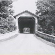
Photograph- End view of Kurtz's Mill covered bridge across Big Conestoga, north of Fairmount.
Object ID
1-09-03-34
Date Range
August 1956
More detail
1 image
Object Name
Print, Photographic
Collection
General Collection
Title
Photograph- End view of Kurtz's Mill covered bridge across Big Conestoga, north of Fairmount.
Description
End view of Kurtz's Mill covered bridge across Big Conestoga.
Provenance
Lancaster County covered bridge photos taken by M. E. Schroll and Kathryn L. Sauder taken between 1956 and 1958.
Date Range
August 1956
Storage Location
LancasterHistory, Lancaster, PA
Subcategory
Documentary Artifact
Search Terms
Covered bridges
Conestoga River
Kurtz's Mill Covered Bridge
Martindale, Earl Twp.
Place
Earl Twp.
Object Name
Print, Photographic
Print Size
3.5 x 3.5 inches
Condition
Good
Object ID
1-09-03-34
Images
Less detail
More Like This
Permalink
Toggle Full Record
Print, Photographic
https://collections.lancasterhistory.org/en/permalink/7ee8a894-f2c8-40a8-a73d-184924791605
Collection
General Collection
Object ID
1-09-03-77
Date Range
August 1956
More detail
1 image
Object Name
Print, Photographic
Collection
General Collection
Description
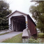
Kurtz's Mill covered bridge across the Conestoga River.
Provenance
Lancaster County covered bridge photos taken by M. E. Schroll and Kathryn L. Sauder taken between 1956 and 1958.
Date Range
August 1956
Storage Location
LancasterHistory, Lancaster, PA
Subcategory
Documentary Artifact
Search Terms
Kurtz's Mill Covered Bridge
Covered bridges
Conestoga River
Place
Earl Twp.
Object Name
Print, Photographic
Print Size
3.5 x 3.5 inches
Condition
Good
Object ID
1-09-03-77
Images
Less detail
More Like This
Permalink
Toggle Full Record
Print, Photographic
https://collections.lancasterhistory.org/en/permalink/dc74fc5a-3399-4e48-ace8-012576676623
Collection
General Collection
Object ID
1-09-03-78
Date Range
August 7, 1958
More detail
1 image
Object Name
Print, Photographic
Collection
General Collection
Description
Kurtz's Mill covered bridge on the Conestoga River.
Provenance
Lancaster County covered bridge photos taken by M. E. Schroll and Kathryn L. Sauder taken between 1956 and 1958.
Date Range
August 7, 1958
Storage Location
LancasterHistory, Lancaster, PA
Subcategory
Documentary Artifact
Search Terms
Kurtz's Mill Covered Bridge
Covered bridges
Conestoga River
Place
Earl Twp.
Object Name
Print, Photographic
Print Size
3.5 x 3.5 inches
Condition
Good
Object ID
1-09-03-78
Images
Less detail
More Like This
Permalink
Toggle Full Record
Print, Photographic
https://collections.lancasterhistory.org/en/permalink/12d30501-dce0-40a2-aaed-224545388827
Collection
General Collection
Object ID
1-20-04-59
More detail
1 image
Object Name
Print, Photographic
Collection
General Collection
Description
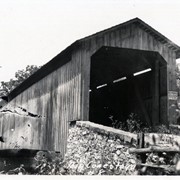
Covered bridge. Bridge number 8 over the Conestoga River, possibly Kurtz's Mill Covered Bridge.
Provenance
Photographs taken by Lancaster County during bridge repair work. Gift of Gordon Reed.
Year Range From
1920
Year Range To
1929
Storage Location
LancasterHistory, Lancaster, PA
Search Terms
Covered bridges
Conestoga River
Kurtz's Mill Covered Bridge
Place
Earl Twp.
Object Name
Print, Photographic
Print Size
3.25 x 5.5 inches
Object ID
1-20-04-59
Images
Less detail
More Like This
Permalink
Toggle Full Record
Print, Photographic
https://collections.lancasterhistory.org/en/permalink/187a6bad-44c3-40b7-8fca-633731366027
Collection
General Collection
Object ID
1-20-04-60
More detail
1 image
Object Name
Print, Photographic
Collection
General Collection
Description
Covered bridge. Bridge number 8 over the Conestoga River, possibly Kurtz's Mill Covered Bridge.
Provenance
Photographs taken by Lancaster County during bridge repair work. Gift of Gordon Reed.
Year Range From
1920
Year Range To
1929
Storage Location
LancasterHistory, Lancaster, PA
Search Terms
Covered bridges
Conestoga River
Kurtz's Mill Covered Bridge
Place
Earl Twp.
Object Name
Print, Photographic
Print Size
3.25 x 5.5 inches
Object ID
1-20-04-60
Images
Less detail
More Like This
Permalink
Toggle Full Record
Print, Photographic
https://collections.lancasterhistory.org/en/permalink/3c896f35-a464-4cb4-adfb-459635371613
Collection
General Collection
Object ID
1-20-04-82
More detail
1 image
Object Name
Print, Photographic
Collection
General Collection
Description
Bridge #2 over Muddy Creek, possibly Red Run Covered Bridge
Provenance
Photographs taken by Lancaster County during bridge repair work. Gift of Gordon Reed.
Year Range From
1920
Year Range To
1929
Storage Location
LancasterHistory, Lancaster, PA
Search Terms
Covered bridges
Muddy Creek
Red Run Covered Bridge
Place
Earl Twp.
Object Name
Print, Photographic
Print Size
3.25 x 5.5 inches
Object ID
1-20-04-82
Images
Less detail
More Like This
Permalink
Toggle Full Record
Print, Photographic
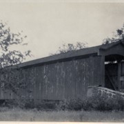
https://collections.lancasterhistory.org/en/permalink/2490d8f5-2c33-4bd3-9d29-821404032960
Collection
General Collection
Title
Kurtz's Mill Covered Bridge
Object ID
1-21-03-58
Date Range
26 April 1972
More detail
1 image
Object Name
Print, Photographic
Collection
General Collection
Title
Kurtz's Mill Covered Bridge
Description
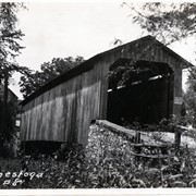
Kurtz's Mill Covered Bridge near Hinkletown.
Date Range
26 April 1972
Storage Location
LancasterHistory, Lancaster, PA
Storage Room
Archives West
People
Bond, G. Ross
Subject
Photographs
Classification
1-21-03-58
Search Terms
Mills
Covered bridges
Kurtz's Mill Covered Bridge
Hinkletown, Earl Twp.
Conestoga River
Place
Earl Twp.
Object Name
Print, Photographic
Original or Copy
Original
Print Size
4 x 5 inches
Dimention Details
Photograph is glued to black paper
Object ID
1-21-03-58
Credit
Courtesy of LancasterHistory, Lancaster, Pennsylvania
Images
Less detail
More Like This
Permalink
Toggle Full Record
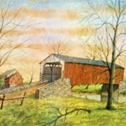
Postcard
https://collections.lancasterhistory.org/en/permalink/a495a7af-d75f-4d81-abcb-254989207739
Collection
Postcard Collection
Object ID
958-002
More detail
1 image
Object Name
Postcard
Collection
Postcard Collection
Description
Fry's Mill Bridge near Hinkletown, PA. From an original pen and ink and watercolor painting by Jay McVey of Akron, PA.
Storage Location
LancasterHistory, Lancaster, PA
Subcategory
Written Communication T&E
Search Terms
Fry's Mill Covered Bridge
Hinkletown, Earl Twp.
Covered bridges
Place
Earl Twp.
Object Name
Postcard
Print Size
4 x 6 inches
Publisher
Jay McVey, Akron, PA
Object ID
958-002
Images
Less detail
More Like This
Permalink
Toggle Full Record
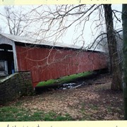
Print, Photographic
https://collections.lancasterhistory.org/en/permalink/c9d0cd57-b5f6-4785-b53f-774787738625
Collection
Covered Bridge Safari Album
Object ID
A-65-01-23
Date Range
April 5, 2003
More detail
1 image
Object Name
Print, Photographic
Collection
Covered Bridge Safari Album
Description
Red Run covered bridge, built in 1866, formerly over Muddy Creek. The creek was diverted and a new bridge built over it in 1961.
Provenance
Photographs of a 2003 Theodore Burr Covered Bridge Society bridge safari.
Date Range
April 5, 2003
Storage Location
LancasterHistory, Lancaster, PA
Subcategory
Documentary Artifact
Search Terms
Covered bridges
Bridges
Red Run covered bridge
Muddy Creek
Place
Earl Twp.
Object Name
Print, Photographic
Print Size
4 x 6 inches
Object ID
A-65-01-23
Images
Less detail
More Like This
Permalink
Toggle Full Record
Print, Photographic
https://collections.lancasterhistory.org/en/permalink/6e707033-fe8c-4ad4-9040-910484236039
Collection
Covered Bridge Safari Album
Object ID
A-65-01-24
Date Range
April 5, 2003
More detail
1 image
Object Name
Print, Photographic
Collection
Covered Bridge Safari Album
Description
Red Run covered bridge, built in 1866, formerly over Muddy Creek. The creek was diverted and a new bridge built over it in 1961.
Provenance
Photographs of a 2003 Theodore Burr Covered Bridge Society bridge safari.
Date Range
April 5, 2003
Storage Location
LancasterHistory, Lancaster, PA
Subcategory
Documentary Artifact
Search Terms
Covered bridges
Bridges
Red Run covered bridge
Muddy Creek
Place
Earl Twp.
Object Name
Print, Photographic
Print Size
4 x 6 inches
Object ID
A-65-01-24
Images
Less detail
More Like This
Permalink
18 records – page 1 of 2.
Prev
Next