Skip header and navigation

Revise Search

20 records – page 1 of 1.

Collection
General Collection
Object ID
3-13-01-13
Date Range
1976
  1 image  
Object Name
Print, Photographic
Collection
General Collection
Description
"Natural Bridge". Lancaster County Bicentennial Traveling Photo Contest Winners. Covered bridge over creek.
Date Range
1976
Creator
Charles, Jonathan E.
Storage Location
LancasterHistory, Lancaster, PA
Subcategory
Documentary Artifact
Search Terms
Bridges
Covered bridges
Object Name
Print, Photographic
Print Size
13 x 9.5 inches
Dimention Details
Photo on 18 x 14.5 inch mount
Object ID
3-13-01-13
Images
Less detail
Collection
General Collection
Object ID
3-12-01-17
Date Range
1976
  1 image  
Object Name
Print, Photographic
Collection
General Collection
Description
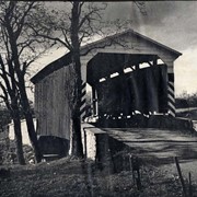
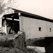
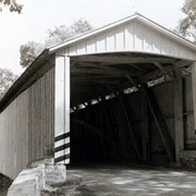
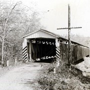
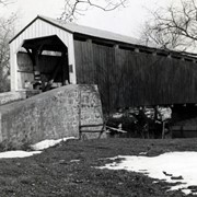
"Bicycling on a Sunday Afternoon". Lancaster County Bicentennial Traveling Photo Contest Winners. Three people bicycling on a backroad near a covered bridge.
Date Range
1976
Creator
Wechter, Diane
Storage Location
LancasterHistory, Lancaster, PA
Subcategory
Documentary Artifact
Search Terms
Bicycles
Covered bridges
Object Name
Print, Photographic
Print Size
8 x 10 inches
Dimention Details
Photograph on 16 x 20 inch mount
Object ID
3-12-01-17
Images
Less detail
Collection
General Collection
Title
Photograph- Columbia - Wrightsville Bridge from the Wrightsville side of the Susquehanna River. Possibly the bridge burned during the Civil War.
Object ID
1-01-05-36
Date Range
c. 1860
  1 image  
Object Name
Print, Photographic
Collection
General Collection
Title
Photograph- Columbia - Wrightsville Bridge from the Wrightsville side of the Susquehanna River. Possibly the bridge burned during the Civil War.
Description
Columbia - Wrightsville Bridge from the Wrightsville side of the Susquehanna River. Possibly the bridge burned during the Civil War.
Date Range
c. 1860
Storage Location
LancasterHistory, Lancaster, PA
Subcategory
Documentary Artifact
Search Terms
Covered bridges
Susquehanna River
Place
Wrightsville, York County, Pennsylvania
Object Name
Print, Photographic
Print Size
7 x 5 inches; 5 x 3.75 inches
Object ID
1-01-05-36
Notes
Two copies.
Images
Less detail
Collection
General Collection
Title
Photograph- Columbia - Wrightsville Bridge from the Wrightsville side of the Susquehanna River.
Object ID
1-01-05-35
Date Range
c. 1860
  1 image  
Object Name
Print, Photographic
Collection
General Collection
Title
Photograph- Columbia - Wrightsville Bridge from the Wrightsville side of the Susquehanna River.
Description
Columbia - Wrightsville Bridge from the Wrightsville side of the Susquehanna River.
Date Range
c. 1860
Storage Location
LancasterHistory, Lancaster, PA
Subcategory
Documentary Artifact
Search Terms
Covered bridges
Susquehanna River
Place
Wrightsville, York County, Pennsylvania
Object Name
Print, Photographic
Film Size
5 x 4 inches
Print Size
7 x 5 inches
Object ID
1-01-05-35
Notes
Two copies.
Negative Number
yes
Images
Less detail
Collection
General Collection
Object ID
2-07-05-05
Date Range
1896
  1 image  
Object Name
Print, Photographic
Collection
General Collection
Description
Columbia - Wrightsville Bridge bridge after the hurricane blew it down
Date Range
1896
Storage Location
LancasterHistory, Lancaster, PA
Subcategory
Documentary Artifact
Search Terms
Columbia - Wrightsville Bridge
Covered bridges
Hurricanes
Susquehanna River
Ferries
Place
Columbia
Object Name
Print, Photographic
Object ID
2-07-05-05
Images
Less detail
Collection
General Collection
Object ID
1-09-05-33
Date Range
c. 1960
  1 image  
Object Name
Print, Photographic
Collection
General Collection
Description
Covered bridge of Conestoga Creek northwest of Long's Park
Provenance
digital image only - original owned by Milton Haldeman
Date Range
c. 1960
Storage Location
LancasterHistory, Lancaster, PA
Subcategory
Documentary Artifact
Search Terms
Covered bridges
Conestoga Creek
Long's Park
Place
East Hempfield Twp.
Object Name
Print, Photographic
Condition
Good
Object ID
1-09-05-33
Images
Less detail
Collection
General Collection
Object ID
1-09-05-34
Date Range
c. 1960
  1 image  
Object Name
Print, Photographic
Collection
General Collection
Description
Poole Forge Bridge, west of Churchtown in Caernarvon Township on starting branch if Conestoga Creek. 99 feet long, built 1859.
Provenance
digital image only - original owned by Milton Haldeman
Date Range
c. 1960
Storage Location
LancasterHistory, Lancaster, PA
Subcategory
Documentary Artifact
Search Terms
Poole Forge
Churchtown, Caernarvon Twp.
Conestoga Creek
Covered bridges
Place
Caernarvon Twp.
Object Name
Print, Photographic
Condition
Good
Object ID
1-09-05-34
Images
Less detail
Collection
General Collection
Object ID
1-09-05-35
Date Range
c. 1960
  1 image  
Object Name
Print, Photographic
Collection
General Collection
Description
Isaac Shearer's Mill bridge, one mile north of Goodville in Caernarvon Township on starting branch of the Conestoga Creek. 8 feet long, built in 1878.
Provenance
digital image only - original owned by Milton Haldeman
Date Range
c. 1960
Storage Location
LancasterHistory, Lancaster, PA
People
Shearer, Isaac
Subcategory
Documentary Artifact
Search Terms
Shearer's Mill
Goodville, East Earl Twp.
Conestoga Creek
Covered bridges
Place
Caernarvon Twp.
Object Name
Print, Photographic
Condition
Good
Object ID
1-09-05-35
Images
Less detail
Collection
General Collection
Object ID
1-09-05-36
Date Range
c. 1960
  1 image  
Object Name
Print, Photographic
Collection
General Collection
Description
Israel Sensenig Mill bridge, Earl Township, on Conestoga Creek. 65 feet long, built in 1857.
Provenance
digital image only - original owned by Milton Haldeman
Date Range
c. 1960
Storage Location
LancasterHistory, Lancaster, PA
People
Sensenig, Israel
Subcategory
Documentary Artifact
Search Terms
Sensenig's Mill
Conestoga Creek
Covered bridges
Place
Earl Twp.
Object Name
Print, Photographic
Condition
Good
Object ID
1-09-05-36
Images
Less detail
Collection
General Collection
Object ID
1-09-05-37
  1 image  
Object Name
Print, Photographic
Collection
General Collection
Description
Isaac Bear's Mill bridge one mile south west of Martindale Road in Earl Township on the Conestoga Creek. 94 feet long, built in 1876.
Provenance
digital image only - original owned by Milton Haldeman
Storage Location
LancasterHistory, Lancaster, PA
People
Bear, Isaac
Subcategory
Documentary Artifact
Search Terms
Bear's Mill
Martindale, Earl Twp.
Conestoga Creek
Covered bridges
Place
Earl Twp.
Object Name
Print, Photographic
Condition
Good
Object ID
1-09-05-37
Images
Less detail
Collection
General Collection
Object ID
1-09-05-38
  1 image  
Object Name
Print, Photographic
Collection
General Collection
Description
Martin's Mill bridge, two miles south of Murrell in Ephrata Township on Conestoga Creek. 98 1/2 feet long, built in 1846.
Provenance
digital image only - original owned by Milton Haldeman
Storage Location
LancasterHistory, Lancaster, PA
Subcategory
Documentary Artifact
Search Terms
Murrell, Ephrata Twp.
Covered bridges
Conestoga Creek
Place
Ephrata Twp.
Object Name
Print, Photographic
Condition
Good
Object ID
1-09-05-38
Images
Less detail
Collection
General Collection
Object ID
1-09-05-39
  1 image  
Object Name
Print, Photographic
Collection
General Collection
Description
Nolt's Point Mill bridge near William Shand residence in Upper Leacock Township on Conestoga Creek. 133 feet long, built in 1867.
Provenance
digital image only - original owned by Milton Haldeman
Storage Location
LancasterHistory, Lancaster, PA
People
Shand, William
Subcategory
Documentary Artifact
Search Terms
Nolt's Mill
Pinetown, Upper Leacock Twp.
Conestoga Creek
Covered bridges
Place
Manheim Twp.
Object Name
Print, Photographic
Condition
Good
Object ID
1-09-05-39
Images
Less detail
Collection
General Collection
Object ID
1-09-05-40
  1 image  
Object Name
Print, Photographic
Collection
General Collection
Description
Hunsecker's Mill between Manheim and Upper Leacock Townships on Conestoga Creek. 180 feet long, built in 1848.
Provenance
digital image only - original owned by Milton Haldeman
Storage Location
LancasterHistory, Lancaster, PA
Subcategory
Documentary Artifact
Search Terms
Hunsecker's Mill
Manheim Twp.
Upper Leacock Twp.
Conestoga Creek
Covered bridges
Object Name
Print, Photographic
Condition
Good
Object ID
1-09-05-40
Images
Less detail
Collection
General Collection
Object ID
1-09-05-41
  1 image  
Object Name
Print, Photographic
Collection
General Collection
Description
Israel Groff's Factory bridge at water's edge in Lancaster Township, a half mile south of Eden on the Conestoga River. 158 feet long, built in 1848.
Provenance
digital image only - original owned by Milton Haldeman
Storage Location
LancasterHistory, Lancaster, PA
Subcategory
Documentary Artifact
Search Terms
Groff Factory Bridge
Lancaster Twp.
Conestoga River
Covered bridges
Place
Lancaster Twp.
Object Name
Print, Photographic
Condition
Good
Object ID
1-09-05-41
Images
Less detail
Collection
General Collection
Object ID
1-09-05-42
  1 image  
Object Name
Print, Photographic
Collection
General Collection
Description
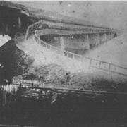
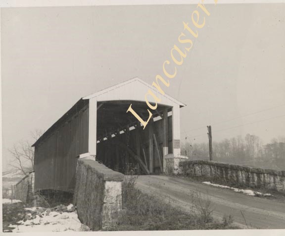
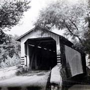
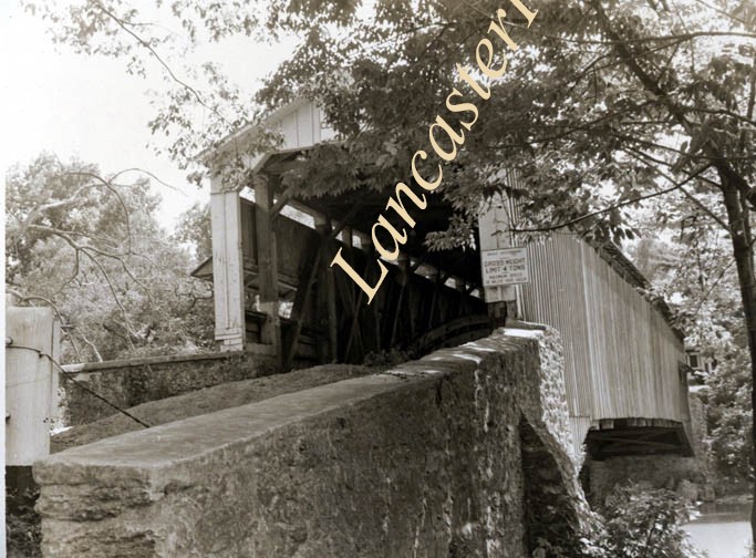
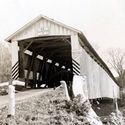
Snavely's Mill bridge south of Lancaster city between Lancaster and Pequea Townships. Longest double span in Lancaster County. 349 feet long. First bridge built in 1836, second in 1850. On the Conestoga River.
Provenance
digital image only - original owned by Milton Haldeman
Storage Location
LancasterHistory, Lancaster, PA
Subcategory
Documentary Artifact
Search Terms
Snavely's Mill
Lancaster Twp.
Covered bridges
Pequea Twp.
Conestoga River
Object Name
Print, Photographic
Condition
Good
Object ID
1-09-05-42
Images
Less detail
Collection
General Collection
Object ID
1-09-05-43
  1 image  
Object Name
Print, Photographic
Collection
General Collection
Description
Wabank bridge between New Danville and Millersville in Pequea Township on the Conestoga River. Double span, 246 feet long, built in 1841.
Provenance
digital image only - original owned by Milton Haldeman
Storage Location
LancasterHistory, Lancaster, PA
Subcategory
Documentary Artifact
Search Terms
Bridges
Conestoga River
Covered bridges
Millersville
New Danville, Pequea Twp.
Pequea Twp.
Wabank Bridge
Place
Pequea Twp.
Object Name
Print, Photographic
Condition
Good
Object ID
1-09-05-43
Images
Less detail
Collection
General Collection
Object ID
1-09-05-44
  1 image  
Object Name
Print, Photographic
Collection
General Collection
Description
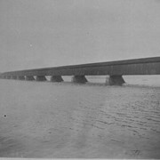
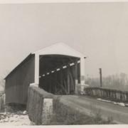
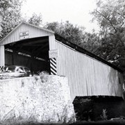
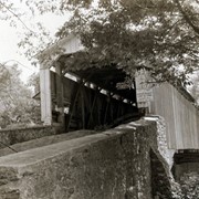
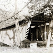
Slackwater bridge, also known as Shober's Paper Mill bridge, one mile south of Millersville between Conestoga and Manor Townships. Oldest bridge still standing on Conestoga River. Double span, 269 feet, built in 1839.
Provenance
digital image only - original owned by Milton Haldeman
Storage Location
LancasterHistory, Lancaster, PA
Subcategory
Documentary Artifact
Search Terms
Slackwater Bridge
Shober's Mill
Conestoga River
Covered bridges
Object Name
Print, Photographic
Condition
Good
Object ID
1-09-05-44
Images
Less detail
Collection
General Collection
Object ID
1-09-05-45
  1 image  
Object Name
Print, Photographic
Collection
General Collection
Description
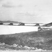
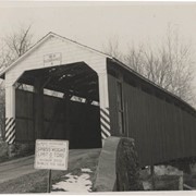
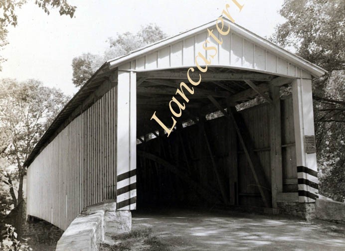
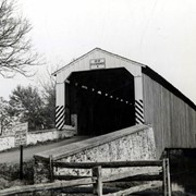
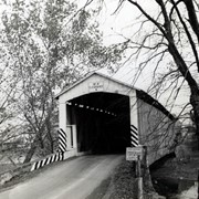
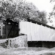
Joseph Oberholtzer's Mill bridge, one and a half miles northwest of Terre Hill between Earl and Brecknock Townships on the Muddy Creek. 128 feet long, built in 1866.
Provenance
digital image only - original owned by Milton Haldeman
Storage Location
LancasterHistory, Lancaster, PA
Subcategory
Documentary Artifact
Search Terms
Oberholtzer's Mill
Muddy Creek
Covered bridges
Place
Muddy Creek
Object Name
Print, Photographic
Condition
Good
Object ID
1-09-05-45
Images
Less detail
Collection
General Collection
Object ID
1-09-05-46
  1 image  
Object Name
Print, Photographic
Collection
General Collection
Description
Fry's Mill in Ephrata Township on Conestoga Creek. 95 feet long, built in 1849.
Provenance
digital image only - original owned by Milton Haldeman
Storage Location
LancasterHistory, Lancaster, PA
Subcategory
Documentary Artifact
Search Terms
Fry's Mill
Conestoga Creek
Covered bridges
Place
Ephrata Twp.
Object Name
Print, Photographic
Condition
Good
Object ID
1-09-05-46
Images
Less detail
Collection
General Collection
Object ID
1-09-05-47
  1 image  
Object Name
Print, Photographic
Collection
General Collection
Description
Bucher's Mill bridge, one half mile west of Reamstown in East Cocalico Township on the Cocalico Creek. 60 feet long, built in 1881.
Provenance
digital image only - original owned by Milton Haldeman
Storage Location
LancasterHistory, Lancaster, PA
Subcategory
Documentary Artifact
Search Terms
Bucher's Mill
Reamstown, East Cocalico Twp.
Cocalico Creek
Covered bridges
Place
East Cocalico Twp.
Object Name
Print, Photographic
Condition
Good
Object ID
1-09-05-47
Images
Less detail

20 records – page 1 of 1.