It appears no script is enabled within your browser. Please enable JavaScript to use this site.
Skip header and navigation
Toggle navigation
Collections
Search
Help
Privacy
Your Selections:
0
Items
Staff Login
Revise Search
Revise Search
Revise search
Search
Data Source
Photographs
7
×
Data Source
All
A
B
C
D
E
F
G
H
I
J
K
L
M
N
O
P
Q
R
S
T
U
V
W
X
Y
Z
Sort
By Count
Alphabetical
Filtered by
Filter
Loading...
Collection
Noreen Weaver Kline Photograph Collection
10
General Collection
John D. Denney, Jr. Photograph Collection
2
×
Collection
All
A
B
C
D
E
F
G
H
I
J
K
L
M
N
O
P
Q
R
S
T
U
V
W
X
Y
Z
Sort
By Count
Alphabetical
Filtered by
Filter
Loading...
Subject
Covered bridges
4
Documentary Artifact
4
Conestoga River
3
Kurtz's Mill Covered Bridge
3
Martindale, Earl Twp.
2
Photographs
2
1-21-03-51
1
1-21-06-68
1
Cemeteries
1
Columbia
1
Columbia High School
1
Construction
1
More
×
Subject
All
A
B
C
D
E
F
G
H
I
J
K
L
M
N
O
P
Q
R
S
T
U
V
W
X
Y
Z
Sort
By Count
Alphabetical
Filtered by
Filter
Loading...
Name
Bond, G. Ross
1
Lockwood, Louis
1
Snyder, Andrew
1
×
Name
All
A
B
C
D
E
F
G
H
I
J
K
L
M
N
O
P
Q
R
S
T
U
V
W
X
Y
Z
Sort
By Count
Alphabetical
Filtered by
Filter
Loading...
Place
Lancaster
284
Carlisle, Cumberland County, Pennsylvania
46
Lancaster Twp.
27
Manheim Twp.
25
Ephrata
16
Tokyo, Japan
13
East Hempfield Twp.
11
Manor Twp.
11
Rapho Twp.
11
East Donegal Twp.
10
Paradise Twp.
9
Ephrata Twp.
8
More
×
Place
All
A
B
C
D
E
F
G
H
I
J
K
L
M
N
O
P
Q
R
S
T
U
V
W
X
Y
Z
Sort
By Count
Alphabetical
Filtered by
Filter
Loading...
Decade
1730s
1
1740s
3
1750s
10
1760s
356
1770s
394
1780s
470
1790s
474
1800s
489
1810s
567
1820s
624
1830s
563
1840s
750
1850s
518
1860s
498
1870s
621
1880s
954
1890s
1225
1900s
735
1910s
207
1920s
13
1930s
21
1940s
7
1950s
1960s
3
1970s
10
1980s
15
1990s
8
2000s
1
×
Decade
All
A
B
C
D
E
F
G
H
I
J
K
L
M
N
O
P
Q
R
S
T
U
V
W
X
Y
Z
Sort
By Count
Alphabetical
Filtered by
Filter
Loading...
Material
Print, Photographic
6
Transparency, Slide
1
×
Material
All
A
B
C
D
E
F
G
H
I
J
K
L
M
N
O
P
Q
R
S
T
U
V
W
X
Y
Z
Sort
By Count
Alphabetical
Filtered by
Filter
Loading...
Online Media
Image
7
×
Online Media
All
A
B
C
D
E
F
G
H
I
J
K
L
M
N
O
P
Q
R
S
T
U
V
W
X
Y
Z
Sort
By Count
Alphabetical
Filtered by
Filter
Loading...
Advanced Search
Help
All Records
Administrators Accounts
Collateral Appraisements
Estate Inventories
Estate Vouchers
Marriage Applications and Consent Forms
Marriage Licenses
Renunciations
Vendue Lists
General Collection
Earl Twp.
Columbia
1950s
Sorted by
Title
Sort by Relevance
Expand All
Collapse All
List View
Gallery View
Print
7 records – page 1 of 1.
Prev
Next
Toggle Full Record
Print, Photographic
https://collections.lancasterhistory.org/en/permalink/88e95bd7-3da3-4069-9425-179343136310
Collection
General Collection
Title
Gravestone of Andrew Snyder
Object ID
1-21-03-51
Date Range
7 July 1959
More detail
1 image
Object Name
Print, Photographic
Collection
General Collection
Title
Gravestone of Andrew Snyder
Description
Grave of Andrew Snyder, b. 17 August 1733, d. 4 November 1845, aged 112 years, 2 months and 18 days. Revolutionary War soldier. Grave has an American flag marker. Zeltenreich Cemetery.
Date Range
7 July 1959
Storage Location
LancasterHistory, Lancaster, PA
Storage Room
Archives West
People
Bond, G. Ross
Snyder, Andrew
Subject
Photographs
Classification
1-21-03-51
Search Terms
Cemeteries
Tombstones
Graves
Graveyards
Zeltenreich Reformed Church
Revolutionary War
Veterans
Flags
Place
Earl Twp.
Object Name
Print, Photographic
Original or Copy
Original
Print Size
4 x 3.75 inches
Dimention Details
Photograph is glued to black paper
Object ID
1-21-03-51
Credit
Courtesy of LancasterHistory, Lancaster, Pennsylvania
Images
Less detail
More Like This
Permalink
Toggle Full Record
Print, Photographic
https://collections.lancasterhistory.org/en/permalink/fd31f801-338a-4091-a7b9-401946346360
Collection
General Collection
Title
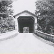
Photograph- End view of Kurtz's Mill covered bridge across Big Conestoga, north of Fairmount.
Object ID
1-09-03-34
Date Range
August 1956
More detail
1 image
Object Name
Print, Photographic
Collection
General Collection
Title
Photograph- End view of Kurtz's Mill covered bridge across Big Conestoga, north of Fairmount.
Description
End view of Kurtz's Mill covered bridge across Big Conestoga.
Provenance
Lancaster County covered bridge photos taken by M. E. Schroll and Kathryn L. Sauder taken between 1956 and 1958.
Date Range
August 1956
Storage Location
LancasterHistory, Lancaster, PA
Subcategory
Documentary Artifact
Search Terms
Covered bridges
Conestoga River
Kurtz's Mill Covered Bridge
Martindale, Earl Twp.
Place
Earl Twp.
Object Name
Print, Photographic
Print Size
3.5 x 3.5 inches
Condition
Good
Object ID
1-09-03-34
Images
Less detail
More Like This
Permalink
Toggle Full Record
Print, Photographic
https://collections.lancasterhistory.org/en/permalink/8e35bf98-08e2-416c-8cae-187699158633
Collection
General Collection
Object ID
1-09-03-76
Date Range
August 1956
More detail
1 image
Object Name
Print, Photographic
Collection
General Collection
Description
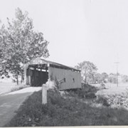
Sensenig's Mill covered bridge, south of Martindale. Replaced in 1957 with a concrete bridge.
Provenance
Lancaster County covered bridge photos taken by M. E. Schroll and Kathryn L. Sauder taken between 1956 and 1958.
Date Range
August 1956
Storage Location
LancasterHistory, Lancaster, PA
Subcategory
Documentary Artifact
Search Terms
Sensenig's Mill
Covered bridges
Martindale, Earl Twp.
Place
Earl Twp.
Object Name
Print, Photographic
Print Size
3.5 x 3.5 inches
Condition
Good
Object ID
1-09-03-76
Images
Less detail
More Like This
Permalink
Toggle Full Record
Print, Photographic
https://collections.lancasterhistory.org/en/permalink/7ee8a894-f2c8-40a8-a73d-184924791605
Collection
General Collection
Object ID
1-09-03-77
Date Range
August 1956
More detail
1 image
Object Name
Print, Photographic
Collection
General Collection
Description
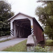
Kurtz's Mill covered bridge across the Conestoga River.
Provenance
Lancaster County covered bridge photos taken by M. E. Schroll and Kathryn L. Sauder taken between 1956 and 1958.
Date Range
August 1956
Storage Location
LancasterHistory, Lancaster, PA
Subcategory
Documentary Artifact
Search Terms
Kurtz's Mill Covered Bridge
Covered bridges
Conestoga River
Place
Earl Twp.
Object Name
Print, Photographic
Print Size
3.5 x 3.5 inches
Condition
Good
Object ID
1-09-03-77
Images
Less detail
More Like This
Permalink
Toggle Full Record
Print, Photographic
https://collections.lancasterhistory.org/en/permalink/dc74fc5a-3399-4e48-ace8-012576676623
Collection
General Collection
Object ID
1-09-03-78
Date Range
August 7, 1958
More detail
1 image
Object Name
Print, Photographic
Collection
General Collection
Description
Kurtz's Mill covered bridge on the Conestoga River.
Provenance
Lancaster County covered bridge photos taken by M. E. Schroll and Kathryn L. Sauder taken between 1956 and 1958.
Date Range
August 7, 1958
Storage Location
LancasterHistory, Lancaster, PA
Subcategory
Documentary Artifact
Search Terms
Kurtz's Mill Covered Bridge
Covered bridges
Conestoga River
Place
Earl Twp.
Object Name
Print, Photographic
Print Size
3.5 x 3.5 inches
Condition
Good
Object ID
1-09-03-78
Images
Less detail
More Like This
Permalink
Toggle Full Record
Print, Photographic
https://collections.lancasterhistory.org/en/permalink/8ac3aca8-5b82-4962-9087-610321472847
Collection
General Collection
Title
Historical marker for the borough of Columbia
Object ID
1-21-06-68
More detail
1 image
Object Name
Print, Photographic
Collection
General Collection
Title
Historical marker for the borough of Columbia
Description
Historical marker for the borough of Columbia, likely located on Route 462.
Year Range From
1950
Year Range To
1959
Creator
Lockwood, Louis
Storage Location
LancasterHistory, Lancaster, PA
Storage Room
Archives West
Subject
Photographs
Classification
1-21-06-68
Search Terms
Historical markers
Columbia
Place
Columbia
Object Name
Print, Photographic
Original or Copy
Original
Print Size
3.5 x 5 inches
Object ID
1-21-06-68
Credit
Courtesy of LancasterHistory, Lancaster, Pennsylvania
Accession Number
2023.Lockwood
Images
Less detail
More Like This
Permalink
Toggle Full Record
Transparency, Slide
https://collections.lancasterhistory.org/en/permalink/346abb69-6433-4b35-a74f-134037454415
Collection
General Collection
Object ID
5-04-02-01
Date Range
c. 1950
More detail
1 image
Object Name
Transparency, Slide
Collection
General Collection
Description
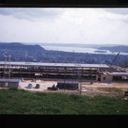
Construction of Columbia High School
Date Range
c. 1950
Storage Location
LancasterHistory, Lancaster, PA
Search Terms
Columbia High School
Construction
Place
Columbia
Object Name
Transparency, Slide
Film Size
35 mm
Object ID
5-04-02-01
Images
Less detail
More Like This
Permalink
7 records – page 1 of 1.
Prev
Next