Skip header and navigation

Revise Search

25 records – page 1 of 3.

Lancaster County, Pennsylvania, street map book : includes Akron, Denver, Mountville, East Petersburg ... and much more

https://collections.lancasterhistory.org/en/permalink/lhdo17746
Corporate Author
ADC (Firm)
Edition
12th ed.
Date of Publication
[c2005]
Call Number
912.74815 A221 12th ed. Oversize
912.74815 A221 12th ed. Landowner's Atlas Stand
Responsibility
ADC.
ISBN
0875306020
9780875306025
Corporate Author
ADC (Firm)
Edition
12th ed.
Place of Publication
Alexandria, VA
Publisher
ADC,
Date of Publication
[c2005]
Physical Description
1 atlas (124 p.) : col. map ; 32 cm.
Notes
Title from cover.
Includes indexes.
Subjects
Lancaster County (Pa.) - Maps.
Location
Lancaster History Library - Lancaster County
Lancaster History Library - Reference
Call Number
912.74815 A221 12th ed. Oversize
912.74815 A221 12th ed. Landowner's Atlas Stand
Less detail

Cecil County, Maryland : street map book

https://collections.lancasterhistory.org/en/permalink/lhdo19213
Corporate Author
ADC (Firm)
Edition
10th ed.
Date of Publication
[c2000]
Call Number
912.75238 A221 10th ed. 2000 Atlas Stand
Alternate Title
Street map book, Cecil County, Maryland
Responsibility
ADC.
ISBN
0875300480
9780875300481
Corporate Author
ADC (Firm)
Edition
10th ed.
Place of Publication
Alexandria, VA
Publisher
ADC,
Date of Publication
[c2000]
Physical Description
1 atlas (40 p.) : col. maps ; 36 cm.
Notes
Cover title.
"Includes Childs, Colora, Elk Mills, Fredericktown, Elk Neck State Park, Stemmers Run WMA."
Includes indexes.
Subjects
Zip codes - Maryland - Cecil County - Maps.
Zip codes.
Cecil County (Md.) - Maps.
Maryland - Cecil County.
Maps.
Location
Lancaster History Library - Reference
Call Number
912.75238 A221 10th ed. 2000 Atlas Stand
Less detail

Lancaster County, Pennsylvania, explorer's map & guide

https://collections.lancasterhistory.org/en/permalink/lhdo18023
Corporate Author
Lancaster County Planning Commission.
Date of Publication
c2000.
Call Number
974.815 LACO 526
Alternate Title
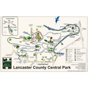
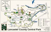
Explorer's map & guide, Lancaster County, Pennsylvania
Explorer's map and guide, Lancaster County, Pennsylvania
Responsibility
[prepared for] Lancaster County Heritage, County of Lancaster, Historic Preservation Trust of Lancaster County, Pennsylvania Dutch Convention and Visitors Bureau.
Corporate Author
Lancaster County Planning Commission.
Place of Publication
[Lancaster, Pa.]
Publisher
Lancaster County Heritage Partnership,
Date of Publication
c2000.
Physical Description
1 map : col. ; 62 x 64 cm., folded to 24 x 10 cm.
Notes
Also shows "Heritage tour routes."
Panel title.
Copyright: 2000 Lancaster County Planning Commission.
"Basemap (c) 1998 Lancaster County GIS Department."
Includes notes, index of "Heritage resources", and col. ill.
Insets: Columbia -- Marietta -- Manheim -- Lititz -- Ephrata -- Lancaster City -- Strasburg -- Intercourse -- Distances from Lancaster County.
Text, descriptive index to points of interest, directory of sponsors, and col. ill. on verso.
Subjects
Heritage tourism - Pennsylvania - Lancaster County - Maps.
Lancaster County (Pa.) - Maps, Tourist.
Lancaster County (Pa.) - Tours - Maps.
Columbia (Pa.) - Maps, Tourist.
Marietta (Pa.) - Maps, Tourist.
Manheim (Pa.) - Maps, Tourist.
Lititz (Pa.) - Maps, Tourist.
Ephrata (Pa.) - Maps, Tourist.
Lancaster (Pa.) - Maps, Tourist.
Strasburg (Pa.) - Maps, Tourist.
Intercourse (Pa.) - Maps, Tourist.
Additional Corporate Author
Lancaster County Heritage Partnership (Pa.)
Historic Preservation Trust of Lancaster County (Pa.)
Pennsylvania Dutch Convention & Visitor's Bureau.
Location
Lancaster History Library - Map
Call Number
974.815 LACO 526
Less detail

Elizabethtown ; Lancaster County

https://collections.lancasterhistory.org/en/permalink/lhdo15532
Edition
2005 ed.
Date of Publication
2005.
Call Number
974.815 ELIZ 100
Alternate Title
City of Elizabethtown & Lancaster County
City of Elizabethtown and Lancaster County
Lancaster County
Edition
2005 ed.
Place of Publication
[S.l
Publisher
Hometown Productions],
Date of Publication
2005.
Physical Description
2 maps on 1 sheet : both sides ; 56 x 88 cm. and 56 x 87 cm. on sheet 58 x 89 cm., folded to 11 x 23 cm.
Notes
Panel title.
Includes location map and advertisements.
Elizabethtown map includes index to streets.
Contents
Elizabethtown -- Lancaster County.
Subjects
Roads - Pennsylvania - Elizabethtown - Maps.
Roads - Pennsylvania - Lancaster County - Maps.
Elizabethtown (Pa.) - Maps.
Lancaster County (Pa.) - Maps.
Location
Lancaster History Library - Map
Call Number
974.815 ELIZ 100
Less detail

Map of Lititz & Manheim, Pennsylvania : happy to help you find your way around

https://collections.lancasterhistory.org/en/permalink/lhdo15533
Corporate Author
Mass Marketing Inc.
Date of Publication
c2005.
Call Number
974.815 LITB 101
Alternate Title
Map of Lititz and Manheim, Pennsylvania
Responsibility
MMI-Mass Marketing Inc.
Corporate Author
Mass Marketing Inc.
Place of Publication
Cincinnati, Ohio
Publisher
Mass Marketing Inc.,
Date of Publication
c2005.
Physical Description
2 maps on 1 sheet : both sides ; 39 x 42 cm. and 43 x 36 cm., on sheet 59 x 45 cm., folded to 23 x 11 cm.
Notes
Panel title.
Includes street indexes and advertisements.
Contents
Lititz -- Manheim.
Subjects
Lititz (Pa.) - Maps.
Manheim (Pa.) - Maps.
Location
Lancaster History Library - Map
Call Number
974.815 LITB 101
Less detail

Lancaster County bicycle map

https://collections.lancasterhistory.org/en/permalink/lhdo15535
Date of Publication
2004.
Call Number
974.815 LACO 523
Responsibility
Steve Spindler Cartography ; Peter Volz Design ; Toole Design Group.
Place of Publication
[S.l.]
Publisher
Toole Design Group,
Date of Publication
2004.
Physical Description
3 maps on 1 sheet : both sides, col. ill. ; 63 x 67 cm. or smaller, on sheet 63 x 76 cm., folded to 22 x 20 cm.
Notes
"December 2004"--Verso.
"Map produced for Lancaster County, Pennsylvania."
Relief shown in shading.
Includes text, illustrations, table of travel time/distance.
Contents
On verso: City of Lancaster -- Transit map: Lancaster city routes - county routes.
Text. Recto: Bicycle tours of Lancaster County. Verso: Loading your bike onto the bus -- Bike shops and clubs -- Bicycle safety tips.
Subjects
Bicycle trails - Pennsylvania - Lancaster County - Maps.
Cycling - Pennsylvania - Lancaster County - Maps.
Roads - Pennsylvania - Lancaster County - Maps.
Lancaster County (Pa.) - Maps.
Lancaster County (Pa.) - Distances - Maps.
Additional Corporate Author
Steve Spindler Cartography (Firm)
Peter Volz Design (Firm)
Toole Design Group.
Lancaster County Planning Commission.
Location
Lancaster History Library - Map
Call Number
974.815 LACO 523
Less detail

The Underground Railroad, explorer's map & guide, Lancaster County, Pennsylvania

https://collections.lancasterhistory.org/en/permalink/lhdo15693
Corporate Author
Lancaster County Heritage (Project)
Edition
2nd ed.
Date of Publication
2001.
Call Number
974.815 LACO 107
Alternate Title
Underground Railroad, explorer's map & guide
Underground Railroad explorer's map and guide
Responsibility
Lancaster County Heritage ; brochure design--Lynn M. Stiles, Lancaster County Planning Commission.
Corporate Author
Lancaster County Heritage (Project)
Edition
2nd ed.
Place of Publication
Lancaster, Pa
Publisher
Lancaster County Heritage,
Date of Publication
2001.
Physical Description
1 map ; 19 x 21 cm., on sheet 59 x 42 cm., folded to 10 x 21 cm.
Notes
Shows Underground Railroad routes in Lancaster County (Pa.).
"September 2001."
Includes text, descriptive index of Underground Railroad historic sites, and location map.
Insets: 1. Columbia -- 2. Lancaster City -- 3. Christiana area.
Text, chronology, and ill. on verso.
Subjects
Underground railroad - Pennsylvania - Lancaster County - Maps.
Historic sites - Pennsylvania - Columbia - Maps.
Historic sites - Pennsylvania - Lancaster - Maps.
Historic sites - Pennsylvania - Christiana Region - Maps.
Heritage tourism - Pennsylvania - Lancaster County - Maps.
Additional Author
Stiles, Lynn M.
Additional Corporate Author
Lancaster County Planning Commission.
Location
Lancaster History Library - Map
Call Number
974.815 LACO 107
Less detail

[Map of Lancaster City, 1871] data CD

https://collections.lancasterhistory.org/en/permalink/lhdo15738
Date of Publication
2001.
Call Number
911.74815 N971 CD
Responsibility
Lancaster County GIS Department.
Place of Publication
Lancaster, PA
Publisher
County of Lancaster, Geographic Information Systems Dept.,
Date of Publication
2001.
Physical Description
1 computer laser optical disc : col. ; 4 3/4 in.
Notes
Title supplied; other title information from disc surface.
Denotes new numbering system of city houses.
Date of situation:1871.
"Index to the numbering system of the City of Lancaster designed by Barnes and Pyott under ordinances of Mar. 3, 1871. The numbers on this map indicate the page on which this block so numbered is found. Buildings actually mentioned have been indicated by black figures. Vacant tracts or buildings not requiring numbers are marked in red figures. Copy for record ordered by Council and completed October 4, 1872"-- Index screen.
"LANC 1872"-Disc title on opening screen.
"Lancaster City Atlas (1872)"--Handwritten on disc surface.
109 TIF images from City of Lancaster, designed by Barnes and Pyott (street map).
Subjects
Lancaster (Pa.) - Maps.
Additional Corporate Author
Lancaster County (Pa.). Geographic Information Systems Dept.
Location
Lancaster History Library - Media
Call Number
911.74815 N971 CD
Less detail

[Frey Farm landfill and Creswell landfill, Lancaster County, Pennsylvania] map

https://collections.lancasterhistory.org/en/permalink/lhdo15830
Corporate Author
Lancaster County Solid Waste Management Authority.
Date of Publication
2002]
Call Number
974.815 LACO 152
  1 document  
Responsibility
Lancaster County Solid Waste Management Authority.
Corporate Author
Lancaster County Solid Waste Management Authority.
Place of Publication
[Lancaster, Pa
Publisher
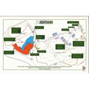
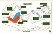
Lancaster County Solid Waste Management Authority,
Date of Publication
2002]
Physical Description
1 map : col. ; 25 x 41 cm.
Notes
Title supplied.
Includes text.
"The Lancaster County Solid Waste Management Authority's mission is to manage solid waste and recyclable materials in an environmentally safe, reliable and efficient manner."
Subjects
Fills (Earthwork) - Pennsylvania - Lancaster County - Maps.
Location
Lancaster History Library - Map
Call Number
974.815 LACO 152
Documents

map_974.815_LACO_152_.pdf

Read PDF Download PDF
Less detail

Lancaster County Central Park map

https://collections.lancasterhistory.org/en/permalink/lhdo15837
Corporate Author
Lancaster County (Pa.). Dept. of Parks and Recreation.
Date of Publication
[2000?]
Call Number
974.815 LACO 148
  1 document  
Responsibility
Lancaster County Department of Parks and Recreation.
Corporate Author
Lancaster County (Pa.). Dept. of Parks and Recreation.
Place of Publication
Lancaster, PA
Publisher
Lancaster County Dept. of Parks and Recreation,
Date of Publication
[2000?]
Physical Description
1 map : col., ill. ; 27 x 42 cm.
Notes
Selected facilities and points of interest shown pictorially.
Oriented with north toward the lower right.
Includes location map (inset).
Subjects
Lancaster County Central Park (Pa.) - Maps.
Lancaster County Central Park (Pa.) - Maps, Pictorial.
Location
Lancaster History Library - Map
Call Number
974.815 LACO 148
Documents

map_974.815_LACO_148_.pdf

Read PDF Download PDF
Less detail

25 records – page 1 of 3.