- Corporate Author
- Lancaster County (Pa.). Dept. of Parks and Recreation.
- Date of Publication
- [2000?]
- Call Number
- 974.815 LACO 148
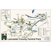
Lancaster Region
Kiwanis .
Lodge
22
.
. .
Shuts
Environmental
Library
To Routes
222/272 Meadia Heights
Golf Club
Native
Wildflower
Meadow
Lancaster
County
Environmental
Center
Environmental
Center Field
_,
0
(!)
Kauffman
Barn
5~ 4 ~f
Skate Park ~ ·.
~ ;
0 Scale
~ Mrles O 11
8 11
4
Q.-..Cllr