It appears no script is enabled within your browser. Please enable JavaScript to use this site.
Skip header and navigation
Toggle navigation
Collections
Search
Help
Privacy
Your Selections:
0
Items
Staff Login
Revise Search
Revise Search
Revise search
Search
Data Source
Photographs
16
×
Data Source
All
A
B
C
D
E
F
G
H
I
J
K
L
M
N
O
P
Q
R
S
T
U
V
W
X
Y
Z
Sort
By Count
Alphabetical
Filtered by
Filter
Loading...
Collection
General Collection
7
Sarah Ann Stauffer Photograph Collection
6
Lancaster 250 Collection
2
Barton Mill Photograph Collection
1
×
Collection
All
A
B
C
D
E
F
G
H
I
J
K
L
M
N
O
P
Q
R
S
T
U
V
W
X
Y
Z
Sort
By Count
Alphabetical
Filtered by
Filter
Loading...
Subject
Documentary Artifact
15
Aerial photographs
3
Covered bridges
3
Farms
2
Mills
2
Snow
2
Airports
1
Bridges
1
Chickies Creek
1
Chiques Creek
1
Conestoga Creek
1
Conestoga River
1
More
×
Subject
All
A
B
C
D
E
F
G
H
I
J
K
L
M
N
O
P
Q
R
S
T
U
V
W
X
Y
Z
Sort
By Count
Alphabetical
Filtered by
Filter
Loading...
Name
Bixler, Robert Theodore
3
Dussinger, Marshall
1
×
Name
All
A
B
C
D
E
F
G
H
I
J
K
L
M
N
O
P
Q
R
S
T
U
V
W
X
Y
Z
Sort
By Count
Alphabetical
Filtered by
Filter
Loading...
Place
Lancaster
545
Lancaster Twp.
43
Strasburg Twp.
34
Columbia
14
East Hempfield Twp.
Lititz
11
Lancaster County
10
Miami Beach, Dade County, Florida
10
Manor Twp.
9
Paradise Twp.
9
Leacock Twp.
8
East Earl Twp.
6
More
×
Place
All
A
B
C
D
E
F
G
H
I
J
K
L
M
N
O
P
Q
R
S
T
U
V
W
X
Y
Z
Sort
By Count
Alphabetical
Filtered by
Filter
Loading...
Decade
1720s
1
1730s
1
1740s
4
1750s
3
1760s
202
1770s
200
1780s
214
1790s
223
1800s
283
1810s
465
1820s
531
1830s
632
1840s
790
1850s
604
1860s
671
1870s
533
1880s
765
1890s
825
1900s
618
1910s
171
1920s
190
1930s
86
1940s
69
1950s
38
1960s
1970s
67
1980s
354
1990s
84
2000s
15
×
Decade
All
A
B
C
D
E
F
G
H
I
J
K
L
M
N
O
P
Q
R
S
T
U
V
W
X
Y
Z
Sort
By Count
Alphabetical
Filtered by
Filter
Loading...
Material
Print, Photographic
16
×
Material
All
A
B
C
D
E
F
G
H
I
J
K
L
M
N
O
P
Q
R
S
T
U
V
W
X
Y
Z
Sort
By Count
Alphabetical
Filtered by
Filter
Loading...
Online Media
Image
16
×
Online Media
All
A
B
C
D
E
F
G
H
I
J
K
L
M
N
O
P
Q
R
S
T
U
V
W
X
Y
Z
Sort
By Count
Alphabetical
Filtered by
Filter
Loading...
Advanced Search
Help
more like: 404D508D-A400-4757-AD74-921478285344
East Hempfield Twp.
Manheim Twp.
1960s
Sorted by
Title
Sort by Relevance
Expand All
Collapse All
List View
Gallery View
Print
10 records – page 1 of 1.
Prev
Next
Toggle Full Record
Print, Photographic
https://collections.lancasterhistory.org/en/permalink/0f2e2d3a-85a9-4176-8f02-358810268710
Collection
General Collection
Object ID
1-09-05-33
Date Range
c. 1960
More detail
1 image
Object Name
Print, Photographic
Collection
General Collection
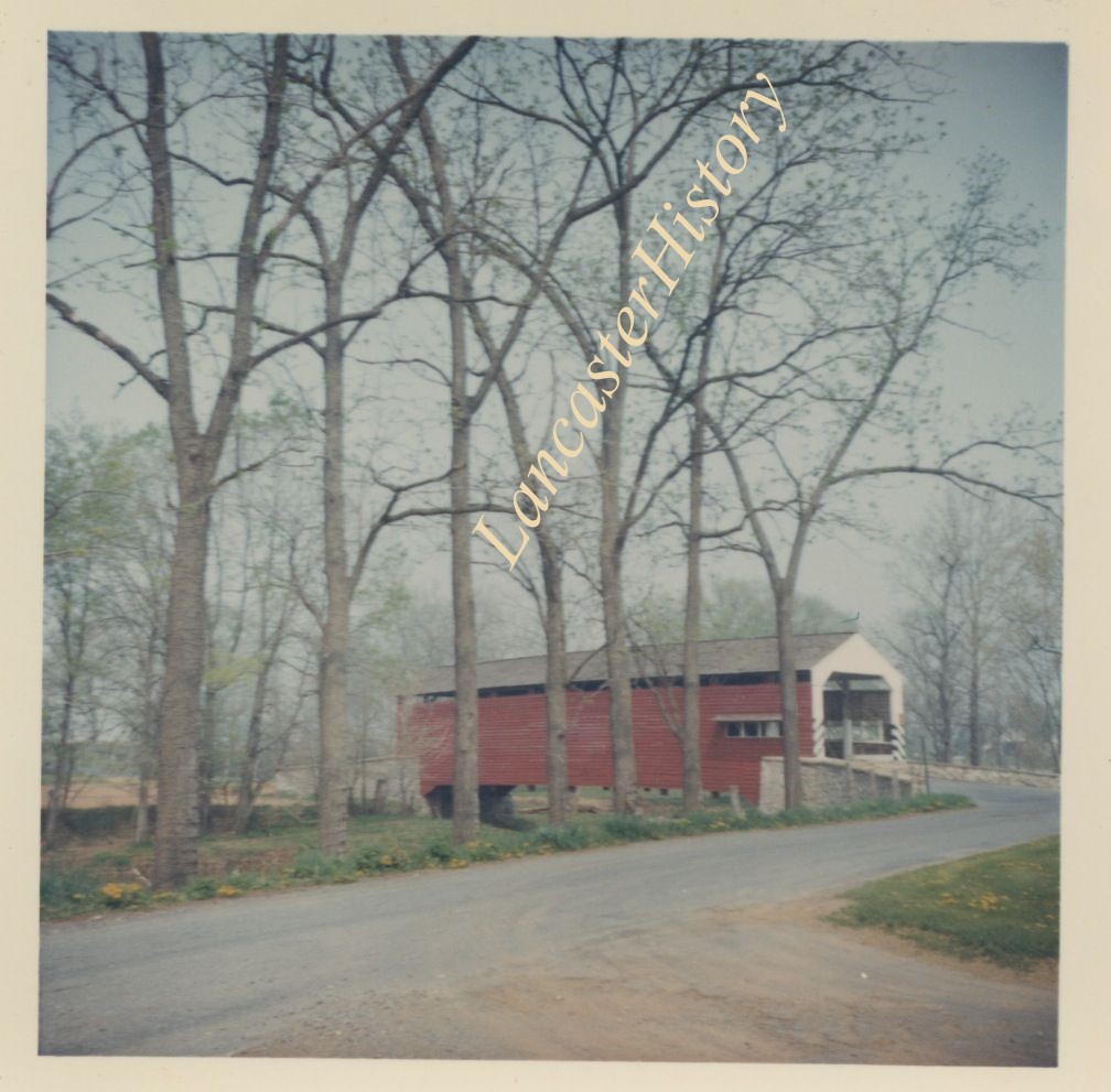
Description
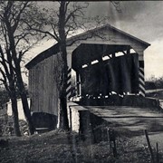
Covered bridge of Conestoga Creek northwest of Long's Park
Provenance
digital image only - original owned by Milton Haldeman
Date Range
c. 1960
Storage Location
LancasterHistory, Lancaster, PA
Subcategory
Documentary Artifact
Search Terms
Covered bridges
Conestoga Creek
Long's Park
Place
East Hempfield Twp.
Object Name
Print, Photographic
Condition
Good
Object ID
1-09-05-33
Images
Less detail
More Like This
Permalink
Toggle Full Record
Print, Photographic
https://collections.lancasterhistory.org/en/permalink/e9102ce0-43cc-4c35-9da9-382483105310
Collection
General Collection
Object ID
2-07-08-10
Date Range
1961
More detail
1 image
Object Name
Print, Photographic
Collection
General Collection
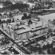
Description
Snowstorm at Rossmere
Date Range
1961
Storage Location
LancasterHistory, Lancaster, PA
Subcategory
Documentary Artifact
Search Terms
Aerial photographs
Snowstorms
Snow
Place
Manheim Twp.
Object Name
Print, Photographic
Print Size
10 x 8 inches
Object ID
2-07-08-10
Images
Less detail
More Like This
Permalink
Toggle Full Record
Print, Photographic
https://collections.lancasterhistory.org/en/permalink/ea7aa69b-b71a-45b2-8b01-081090183942
Collection
Barton Mill Photograph Collection
Object ID
BM-02-014
Date Range
1966
More detail
1 image
Object Name
Print, Photographic
Collection
Barton Mill Photograph Collection
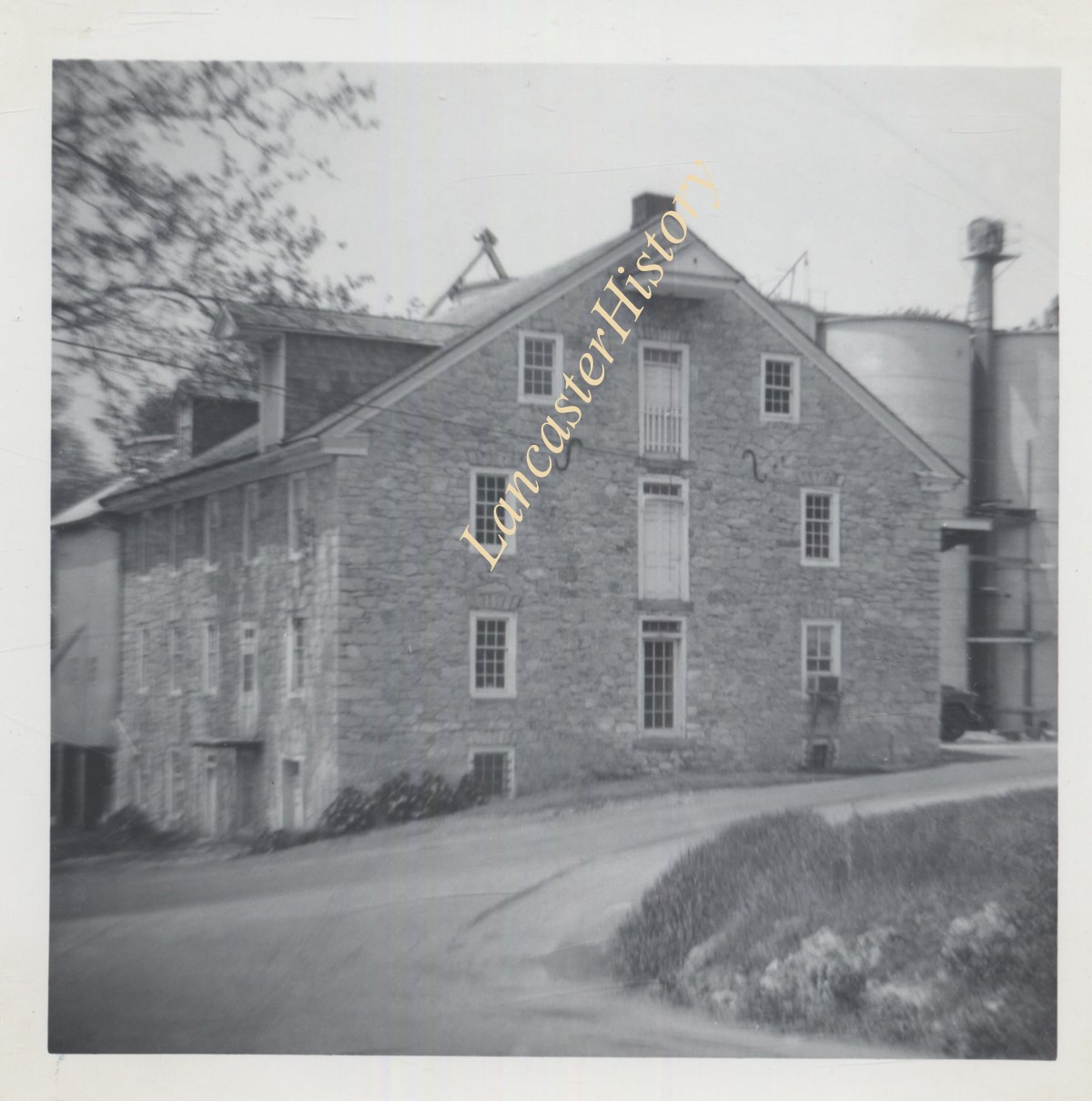
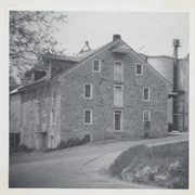
Description
Valley Mill
Provenance
Photographs from "Mills and Bridges of Lancaster County, PA" compiled by R. Harold Barton. Cataloged in LCHS library, call number LC 725.4 B283.
Date Range
1966
Storage Location
LancasterHistory, Lancaster, PA
Search Terms
Valley Mill
Mills
East Hempfield Twp.
Place
East Hempfield Twp.
Object Name
Print, Photographic
Print Size
3 x 5 inches
Condition
Not Rated
Object ID
BM-02-014
Images
Less detail
More Like This
Permalink
Toggle Full Record
Print, Photographic
https://collections.lancasterhistory.org/en/permalink/b47e8b72-55f1-4633-aa43-560780265751
Collection
General Collection
Object ID
2-07-08-07
Date Range
1961
More detail
1 image
Object Name
Print, Photographic
Collection
General Collection
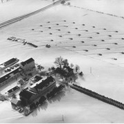
Description
Snowstorm showing farm near Glen Moore Circle
Date Range
1961
Storage Location
LancasterHistory, Lancaster, PA
Subcategory
Documentary Artifact
Search Terms
Snow
Farms
Winter
Place
Manheim Twp.
Object Name
Print, Photographic
Print Size
10 x 8 inches
Object ID
2-07-08-07
Images
Less detail
More Like This
Permalink
Toggle Full Record
Print, Photographic
https://collections.lancasterhistory.org/en/permalink/d2660c69-5d74-4b82-9279-415819893410
Collection
General Collection
Object ID
1-11-04-63
Date Range
June 1965
More detail
1 image
Object Name
Print, Photographic
Collection
General Collection
Description
Flory's Mill
Provenance
Gift of Beverly Wagaman
Date Range
June 1965
Creator
Bixler, Robert Theodore
Storage Location
LancasterHistory, Lancaster, PA
Subcategory
Documentary Artifact
Search Terms
Mills
Place
East Hempfield Twp.
Object Name
Print, Photographic
Print Size
3 x 3 inches
Object ID
1-11-04-63
Images
Less detail
More Like This
Permalink
Toggle Full Record
Print, Photographic
https://collections.lancasterhistory.org/en/permalink/22ddf5a7-257f-43d9-9941-660655550015
Collection
General Collection
Object ID
1-11-04-73
Date Range
1968
More detail
1 image
Object Name
Print, Photographic
Collection
General Collection
Description
Moore's covered bridge near Silver Spring off of the Marietta Pike.
Provenance
Gift of Beverly Wagaman
Date Range
1968
Creator
Bixler, Robert Theodore
Storage Location
LancasterHistory, Lancaster, PA
Subcategory
Documentary Artifact
Search Terms
Covered bridges
Chiques Creek
Chickies Creek
Place
East Hempfield Twp.
Object Name
Print, Photographic
Print Size
3 x 3 inches
Object ID
1-11-04-73
Images
Less detail
More Like This
Permalink
Toggle Full Record
Print, Photographic
https://collections.lancasterhistory.org/en/permalink/95325e55-828e-4a78-9718-014839942598
Collection
General Collection
Object ID
1-11-04-95
Date Range
1968
More detail
1 image
Object Name
Print, Photographic
Collection
General Collection
Description
Shenk's Mill covered bridge.
Provenance
Gift of Beverly Wagaman
Date Range
1968
Creator
Bixler, Robert Theodore
Storage Location
LancasterHistory, Lancaster, PA
Subcategory
Documentary Artifact
Search Terms
Covered bridges
Place
East Hempfield Twp.
Object Name
Print, Photographic
Print Size
3 x 3 inches
Object ID
1-11-04-95
Images
Less detail
More Like This
Permalink
Toggle Full Record
Print, Photographic
https://collections.lancasterhistory.org/en/permalink/78006cb1-abdb-48d1-94d6-534427412727
Collection
General Collection
Object ID
2-09-01-37
Date Range
1969
More detail
1 image
Object Name
Print, Photographic
Collection
General Collection
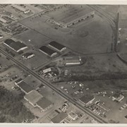
Description
Aerial view of the site of the former Manheim Pike airport as it appeared in 1969.
Provenance
Donated by Jessie Jones Eckhart.
Date Range
1969
Creator
Dussinger, Marshall
Storage Location
LancasterHistory, Lancaster, PA
Subcategory
Documentary Artifact
Search Terms
Manheim Pike
Airports
Aerial photographs
Place
Manheim Twp.
Object Name
Print, Photographic
Object ID
2-09-01-37
Negative Number
no
Images
Less detail
More Like This
Permalink
Toggle Full Record
Print, Photographic
https://collections.lancasterhistory.org/en/permalink/1875e44b-4174-4b8f-96d2-381131343230
Collection
Lancaster 250 Collection
Object ID
A-09-01-25
Date Range
c. 1966
More detail
1 image
Object Name
Print, Photographic
Collection
Lancaster 250 Collection
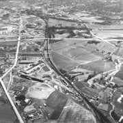
Description
Aerial view of the farm that later became the site of Park City Shopping Center in 1970. Farm bounded by Route 30, Harrisburg Pike and the railroad tracks near Manheim Pike.
Date Range
c. 1966
Storage Location
LancasterHistory, Lancaster, PA
Subcategory
Documentary Artifact
Search Terms
Route 30
Harrisburg Pike
Farms
Aerial photographs
Place
Manheim Twp.
Object Name
Print, Photographic
Film Size
5 x 4 inches
Print Size
5 x 7 inches
Object ID
A-09-01-25
Negative Number
yes
Other Number
PC-25
Images
Less detail
More Like This
Permalink
Toggle Full Record
Print, Photographic
https://collections.lancasterhistory.org/en/permalink/e6129788-e0b2-410f-beba-398082043352
Collection
Lancaster 250 Collection
Title
Train wreck on Conestoga River Bridge
Object ID
A-09-02-52
Date Range
1960/02/02
More detail
1 image
Object Name
Print, Photographic
Collection
Lancaster 250 Collection
Title
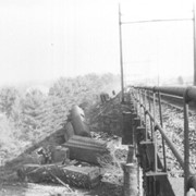
Train wreck on Conestoga River Bridge
Description
Pennsylvania freight train wreck on Conestoga River Bridge at Grofftown Road. Train was carrying United States Mail.
Date Range
1960/02/02
Storage Location
LancasterHistory, Lancaster, PA
Subcategory
Documentary Artifact
Subject
Railroad accidents
Search Terms
Bridges
Conestoga River
Conestoga River Bridge
Grofftown Road
Mail
Manheim Twp.
Railroads
Train accidents
Trains
Place
Manheim Twp.
Object Name
Print, Photographic
Film Size
2.25 x 2.75 inches
Print Size
5 x 7 inches
Object ID
A-09-02-52
Negative Number
yes
Other Number
PC-208
Images
Less detail
More Like This
Permalink
10 records – page 1 of 1.
Prev
Next