Skip header and navigation

Revise Search

10 records – page 1 of 1.

Collection
General Collection
Object ID
2-20-03-22
Date Range
February 10, 1959
  1 image  
Object Name
Print, Photographic
Collection
General Collection
Description
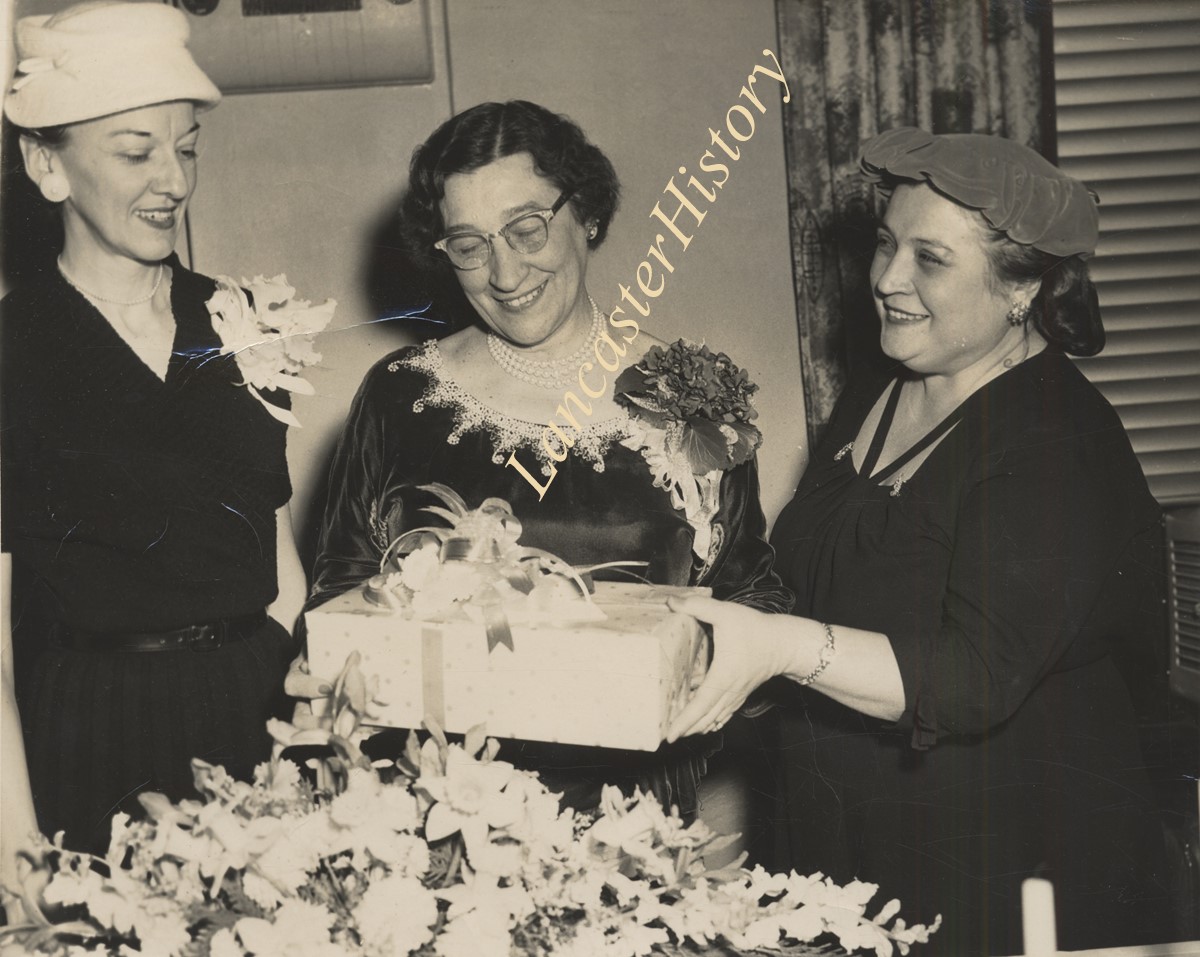
Kathryn Clark (Director of Distrubutive Education, McCaskey High, Lancaster, Pa.receiving Quota Club Award. Mrs. Annie Rutter, Quota Club President on one side and Mrs. walter Kauffman, Chm. Awards Committee on the other. (Information from the back of the picture)
Date Range
February 10, 1959
Storage Location
LancasterHistory, Lancaster, PA
People
Clark, Kathryn Abel
Rutter, Mrs. Annie
Kauffman, Mrs. Walter
Studio
Lancaster Newspapers, Inc.
Subcategory
Documentary Artifact
Search Terms
Awards
Flowers
Quota Club
Object Name
Print, Photographic
Film Size
8 x 10 inches
Object ID
2-20-03-22
Images
Less detail
Collection
General Collection
Object ID
2-20-04-11
Date Range
c. 1954
  1 image  
Object Name
Print, Photographic
Collection
General Collection
Description
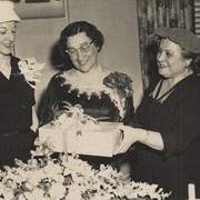
Four high school age young men, in shirts and ties, standing by a Science display titled "Radio Control of Distant Objects." Joseph Clark is on the left.
Date Range
c. 1954
Storage Location
LancasterHistory, Lancaster, PA
People
Clark, Joseph
Studio
Lancaster Newspapers, Inc.
Subcategory
Documentary Artifact
Search Terms
Radios
Schools
Object Name
Print, Photographic
Print Size
7 x 9 inches
Condition
Good
Object ID
2-20-04-11
Images
Less detail
Collection
General Collection
Object ID
2-15-05-24
Date Range
November 4, 1952
  1 image  
Object Name
Print, Photographic
Collection
General Collection
Description
Winners of the "Get-Out-the-Vote" Campaign with their new bicycles.
Date Range
November 4, 1952
Storage Location
LancasterHistory, Lancaster, PA
Studio
Lancaster Newspapers, Inc.
Subcategory
Documentary Artifact
Search Terms
Lancaster Jaycees
Contests
Elections
Place
Lancaster
Object Name
Print, Photographic
Print Size
8 x 10 inches
Object ID
2-15-05-24
Images
Less detail
Collection
Covered Bridge Album
Object ID
A-11-01-01
Date Range
1950
  1 image  
Object Name
Print, Photographic
Collection
Covered Bridge Album
Description
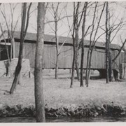
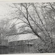
Poole Forge covered bridge, one mile west of Churchtown in Caernarvon Township. State supervised bridge on road LR 36053, built 1859, single span 99 feet long.
Date Range
1950
Creator
Gaintner, Jay Richard
Storage Location
LancasterHistory, Lancaster, PA
Subcategory
Documentary Artifact
Search Terms
Bridges
Covered bridges
Poole Forge
Churchtown, Caernarvon Twp.
Conestoga River
Place
Caernarvon Twp.
Object Name
Print, Photographic
Print Size
8 x 10 inches
Object ID
A-11-01-01
Images
Less detail
Collection
Covered Bridge Album
Object ID
A-11-01-02
Date Range
1950
  1 image  
Object Name
Print, Photographic
Collection
Covered Bridge Album
Description
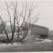
Isaac Shearer's Mill covered bridge, one mile north of Goodville in Caernarvon Township. County maintained on road T-773, built 1878, single span 88 feet long.
Date Range
1950
Creator
Gaintner, Jay Richard
Storage Location
LancasterHistory, Lancaster, PA
People
Shearer, Isaac
Subcategory
Documentary Artifact
Search Terms
Bridges
Covered bridges
Mills
Churchtown, Caernarvon Twp.
Conestoga River
Place
Caernarvon Twp.
Object Name
Print, Photographic
Print Size
8 x 10 inches
Object ID
A-11-01-02
Images
Less detail
Collection
Covered Bridge Album
Object ID
A-11-01-03
Date Range
1950
  1 image  
Object Name
Print, Photographic
Collection
Covered Bridge Album
Description
Israel Sensenig's covered bridge near Martindale in East Earl Township. State supervised on road LR 36013, built 1857, single span 65 feet long.
Date Range
1950
Creator
Gaintner, Jay Richard
Storage Location
LancasterHistory, Lancaster, PA
People
Sensenig, Israel
Subcategory
Documentary Artifact
Search Terms
Bridges
Covered bridges
Mills
Martindale, Earl Twp.
Conestoga River
Place
East Earl Twp.
Object Name
Print, Photographic
Print Size
8 x 10 inches
Object ID
A-11-01-03
Images
Less detail
Collection
Covered Bridge Album
Object ID
A-11-01-04
Date Range
1950
  1 image  
Object Name
Print, Photographic
Collection
Covered Bridge Album
Description
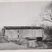
Isaac Bear's Mill covered bridge, one mile southwest of Martindale in East Earl Township. County maintained on road T-674, built in 1876, single span 94 feet long.
Date Range
1950
Creator
Gaintner, Jay Richard
Storage Location
LancasterHistory, Lancaster, PA
People
Bear, Isaac
Subcategory
Documentary Artifact
Search Terms
Bridges
Covered bridges
Mills
Martindale, Earl Twp.
Conestoga River
Place
East Earl Twp.
Object Name
Print, Photographic
Print Size
8 x 10 inches
Object ID
A-11-01-04
Images
Less detail
Collection
Covered Bridge Album
Object ID
A-11-01-05
Date Range
1950
  1 image  
Object Name
Print, Photographic
Collection
Covered Bridge Album
Description
Martin's Mill, also known as Fiences Mill or Eberly's Mill, two miles south of Murrell in West Earl Township. State supervised on road LR 36122, built in 1846, single span 98.5 feet long. Also called Bitzer's Mill.
Date Range
1950
Creator
Gaintner, Jay Richard
Storage Location
LancasterHistory, Lancaster, PA
Subcategory
Documentary Artifact
Search Terms
Bridges
Covered bridges
Mills
Conestoga River
Place
West Earl Twp.
Object Name
Print, Photographic
Print Size
8 x 10 inches
Object ID
A-11-01-05
Images
Less detail
Collection
Covered Bridge Album
Object ID
A-11-01-06
Date Range
1950
  1 image  
Object Name
Print, Photographic
Collection
Covered Bridge Album
Description
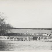
Bushong's Mill, near Oregon between Upper Leacock and Manheim Townships. State supervised on road LR 36009, built in 1843, longest single span in the county, 195 feet long.
Date Range
1950
Creator
Gaintner, Jay Richard
Storage Location
LancasterHistory, Lancaster, PA
Subcategory
Documentary Artifact
Search Terms
Bridges
Covered bridges
Oregon, Manheim Twp.
Mills
Conestoga River
Object Name
Print, Photographic
Print Size
8 x 10 inches
Object ID
A-11-01-06
Images
Less detail
Collection
Covered Bridge Album
Object ID
A-11-01-07
Date Range
1950
  1 image  
Object Name
Print, Photographic
Collection
Covered Bridge Album
Description
Nolt's Point Mill, close to William Shand's residence, .5 mile south of Oregon between Upper Leacock and Manheim Townships. County maintained on road T-620, built in 1867, single span 133 feet long. A beautiful stone bridge is close by.
Date Range
1950
Creator
Gaintner, Jay Richard
Storage Location
LancasterHistory, Lancaster, PA
People
Shand, William
Subcategory
Documentary Artifact
Search Terms
Bridges
Covered bridges
Mills
Conestoga River
Object Name
Print, Photographic
Print Size
8 x 10 inches
Object ID
A-11-01-07
Images
Less detail

10 records – page 1 of 1.