It appears no script is enabled within your browser. Please enable JavaScript to use this site.
Skip header and navigation
Toggle navigation
Collections
Search
Help
Privacy
Your Selections:
0
Items
Staff Login
Revise Search
Revise Search
Revise search
Search
Data Source
Photographs
2
×
Data Source
All
A
B
C
D
E
F
G
H
I
J
K
L
M
N
O
P
Q
R
S
T
U
V
W
X
Y
Z
Sort
By Count
Alphabetical
Filtered by
Filter
Loading...
Collection
General Collection
1
Lancaster 250 Collection
1
×
Collection
All
A
B
C
D
E
F
G
H
I
J
K
L
M
N
O
P
Q
R
S
T
U
V
W
X
Y
Z
Sort
By Count
Alphabetical
Filtered by
Filter
Loading...
Subject
Aerial photographs
1
Documentary Artifact
1
Farms
1
Harrisburg Pike
1
Isaac Long Barn
1
Markers
1
Pennsylvania Historical and Museum Commission
1
Route 30
1
Signs
1
×
Subject
All
A
B
C
D
E
F
G
H
I
J
K
L
M
N
O
P
Q
R
S
T
U
V
W
X
Y
Z
Sort
By Count
Alphabetical
Filtered by
Filter
Loading...
Place
Lancaster
56
West Lampeter Twp.
3
Christiana
2
Manheim Twp.
Akron
1
Drumore Twp.
1
East Earl Twp.
1
Franklin County, Pennsylvania
1
Lancaster Twp.
1
Lebanon County, Pennsylvania
1
Lititz
1
United States Pennsylvania Lancaster Quarryville.
1
More
×
Place
All
A
B
C
D
E
F
G
H
I
J
K
L
M
N
O
P
Q
R
S
T
U
V
W
X
Y
Z
Sort
By Count
Alphabetical
Filtered by
Filter
Loading...
Decade
1810s
3
1830s
1
1860s
1
1870s
1
1890s
1
1920s
4
1930s
1
1940s
6
1960s
1990s
10
2000s
1
×
Decade
All
A
B
C
D
E
F
G
H
I
J
K
L
M
N
O
P
Q
R
S
T
U
V
W
X
Y
Z
Sort
By Count
Alphabetical
Filtered by
Filter
Loading...
Material
Print, Photographic
1
Transparency, Slide
1
×
Material
All
A
B
C
D
E
F
G
H
I
J
K
L
M
N
O
P
Q
R
S
T
U
V
W
X
Y
Z
Sort
By Count
Alphabetical
Filtered by
Filter
Loading...
Online Media
Image
2
×
Online Media
All
A
B
C
D
E
F
G
H
I
J
K
L
M
N
O
P
Q
R
S
T
U
V
W
X
Y
Z
Sort
By Count
Alphabetical
Filtered by
Filter
Loading...
Advanced Search
Help
more like: 82867D19-2872-460D-B6E1-174452078177
1960s
Manheim Twp.
Sorted by
Title
Sort by Relevance
Expand All
Collapse All
List View
Gallery View
Print
2 records – page 1 of 1.
Prev
Next
Toggle Full Record
Print, Photographic
https://collections.lancasterhistory.org/en/permalink/1875e44b-4174-4b8f-96d2-381131343230
Collection
Lancaster 250 Collection
Object ID
A-09-01-25
Date Range
c. 1966
More detail
1 image
Object Name
Print, Photographic
Collection
Lancaster 250 Collection
Description
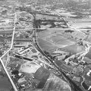
Aerial view of the farm that later became the site of Park City Shopping Center in 1970. Farm bounded by Route 30, Harrisburg Pike and the railroad tracks near Manheim Pike.
Date Range
c. 1966
Storage Location
LancasterHistory, Lancaster, PA
Subcategory
Documentary Artifact
Search Terms
Route 30
Harrisburg Pike
Farms
Aerial photographs
Place
Manheim Twp.
Object Name
Print, Photographic
Film Size
5 x 4 inches
Print Size
5 x 7 inches
Object ID
A-09-01-25
Negative Number
yes
Other Number
PC-25
Images
Less detail
More Like This
Permalink
Toggle Full Record
Transparency, Slide
https://collections.lancasterhistory.org/en/permalink/4acac23a-111d-40a7-94e5-923438267902
Collection
General Collection
Object ID
5-04-02-02
Date Range
1960
More detail
1 image
Object Name
Transparency, Slide
Collection
General Collection
Description
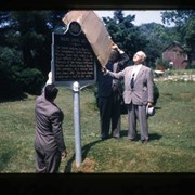
Unveiling of Pennsylvania Historical and Museum Commission marker for the Isaac Long Barn
Date Range
1960
Storage Location
LancasterHistory, Lancaster, PA
Search Terms
Isaac Long Barn
Markers
Signs
Pennsylvania Historical and Museum Commission
Place
Manheim Twp.
Object Name
Transparency, Slide
Film Size
35 mm
Object ID
5-04-02-02
Images
Less detail
More Like This
Permalink