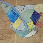
Photograph- A map of the farm attached to the Poor and House of Employment of the County of Lancaster, 1846-1847, unknown artist. See LCHS Journal, Vol. 102, issue 2/3, page 92.
Photograph- A map of the farm attached to the Poor and House of Employment of the County of Lancaster, 1846-1847, unknown artist. See LCHS Journal, Vol. 102, issue 2/3, page 92.
Description
A map of the farm attached to the Poor and House of Employment of the County of Lancaster, 1846-1847, unknown artist. See LCHS Journal, Vol. 102, issue 2/3, page 92.
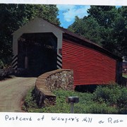
Wenger's Mill covered bridge, also called Rose Hill covered bridge, built in 1849 by Henry Zook. Located on Log Cabin Road, just off of Rose Hill Road. Post card.
Provenance
Photographs of a 2003 Theodore Burr Covered Bridge Society bridge safari.
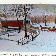
Wenger's Mill covered bridge, also called Rose Hill covered bridge, built in 1849 by Henry Zook. Located on Log Cabin Road, just off of Rose Hill Road. Postcard of painting by Louise Frank.
Provenance
Photographs of a 2003 Theodore Burr Covered Bridge Society bridge safari.