It appears no script is enabled within your browser. Please enable JavaScript to use this site.
Skip header and navigation
Toggle navigation
Collections
Search
Help
Privacy
Your Selections:
0
Items
Staff Login
Revise Search
Revise Search
Revise search
Search
Data Source
Photographs
21
×
Data Source
All
A
B
C
D
E
F
G
H
I
J
K
L
M
N
O
P
Q
R
S
T
U
V
W
X
Y
Z
Sort
By Count
Alphabetical
Filtered by
Filter
Loading...
Collection
General Collection
13
Covered Bridge Album
4
Barton Mill Photograph Collection
3
Leon Landis Album 6
1
×
Collection
All
A
B
C
D
E
F
G
H
I
J
K
L
M
N
O
P
Q
R
S
T
U
V
W
X
Y
Z
Sort
By Count
Alphabetical
Filtered by
Filter
Loading...
Subject
Covered bridges
16
Documentary Artifact
12
Bridges
9
Conestoga River
7
Muddy Creek
5
Martindale, Earl Twp.
2
Mills
2
Oberholtzer's Mill
2
Spring Grove, East Earl Twp.
2
Weaverland, East Earl Twp.
2
Conestoga Creek
1
Goodville, East Earl Twp.
1
More
×
Subject
All
A
B
C
D
E
F
G
H
I
J
K
L
M
N
O
P
Q
R
S
T
U
V
W
X
Y
Z
Sort
By Count
Alphabetical
Filtered by
Filter
Loading...
Name
Barton, R. Harold
3
Bixler, Robert Theodore
2
Gaintner, Jay Richard
2
Krone, Herbert Brickley
2
Bear, Isaac
1
Sensenig, Israel
1
×
Name
All
A
B
C
D
E
F
G
H
I
J
K
L
M
N
O
P
Q
R
S
T
U
V
W
X
Y
Z
Sort
By Count
Alphabetical
Filtered by
Filter
Loading...
Place
Lancaster
73
Manheim Twp.
66
Columbia
42
Colerain Twp.
31
Ephrata Twp.
29
Conestoga Twp.
28
Manor Twp.
28
Earl Twp.
27
Lancaster Twp.
27
Rapho Twp.
23
West Earl Twp.
23
East Earl Twp.
More
×
Place
All
A
B
C
D
E
F
G
H
I
J
K
L
M
N
O
P
Q
R
S
T
U
V
W
X
Y
Z
Sort
By Count
Alphabetical
Filtered by
Filter
Loading...
Decade
1920s
6
1950s
5
1960s
2
1970s
1
×
Decade
All
A
B
C
D
E
F
G
H
I
J
K
L
M
N
O
P
Q
R
S
T
U
V
W
X
Y
Z
Sort
By Count
Alphabetical
Filtered by
Filter
Loading...
Material
Print, Photographic
20
Negative, Glass Plate
1
×
Material
All
A
B
C
D
E
F
G
H
I
J
K
L
M
N
O
P
Q
R
S
T
U
V
W
X
Y
Z
Sort
By Count
Alphabetical
Filtered by
Filter
Loading...
Online Media
Image
×
Online Media
All
A
B
C
D
E
F
G
H
I
J
K
L
M
N
O
P
Q
R
S
T
U
V
W
X
Y
Z
Sort
By Count
Alphabetical
Filtered by
Filter
Loading...
Advanced Search
Help
topic:"Bridges"
Image
East Earl Twp.
Sorted by
Title
Sort by Relevance
Expand All
Collapse All
List View
Gallery View
Print
21 records – page 1 of 3.
Prev
Next
Toggle Full Record
Negative, Glass Plate
https://collections.lancasterhistory.org/en/permalink/29c30797-91b9-45cd-8394-812763383100
Collection
General Collection
Object ID
1-12-01-97
More detail
1 image
Object Name
Negative, Glass Plate
Collection
General Collection
Description
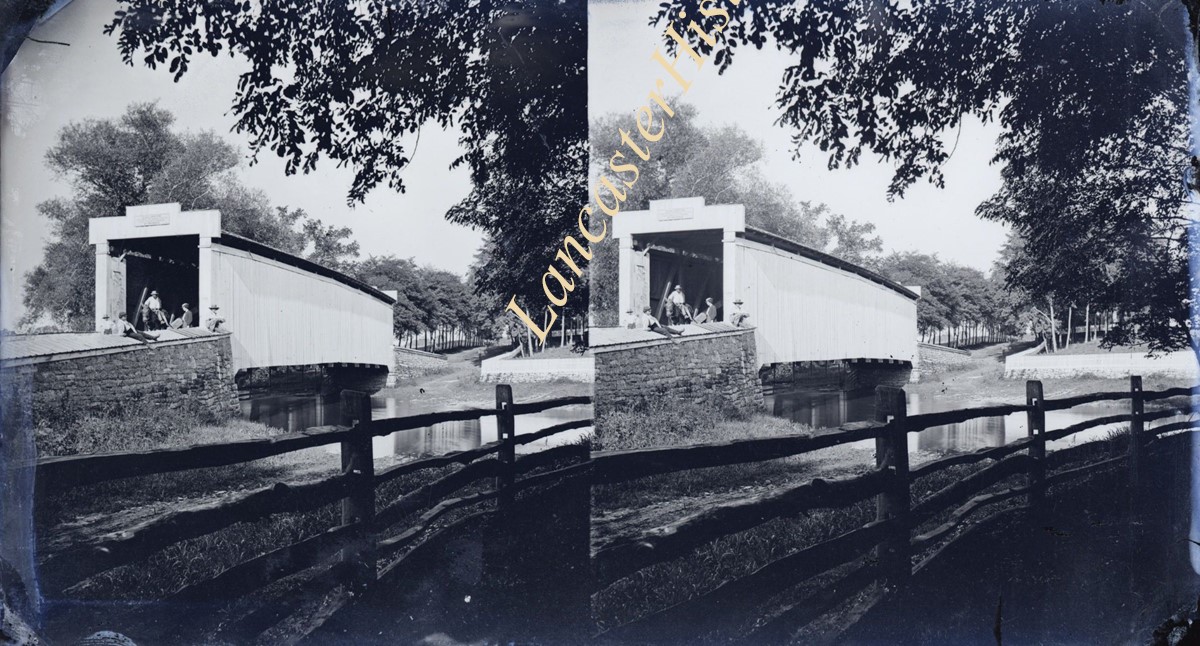
View of covered bridge at Henry Martin's mill, Route 625, East Earl Township, over Conestoga River. Demolished in 1914. Stereoscopic image.
Provenance
Found in Museum Storage
Storage Location
LancasterHistory, Lancaster, PA
Subcategory
Documentary Artifact
Search Terms
Conestoga River
Covered bridges
Place
East Earl Twp.
Object Name
Negative, Glass Plate
Print Size
5 x 7 inches
Object ID
1-12-01-97
Images
Less detail
More Like This
Permalink
Toggle Full Record
Print, Photographic
https://collections.lancasterhistory.org/en/permalink/a4107bb7-d35c-4987-bf28-551177945591
Collection
Leon Landis Album 6
Object ID
A-06-01-50
More detail
1 image
Object Name
Print, Photographic
Collection
Leon Landis Album 6
Description
Trolley bridge over the Conestoga River near Terre Hill. Reprint of postcard.
Storage Location
LancasterHistory, Lancaster, PA
Subcategory
Documentary Artifact
Search Terms
Bridges
Trolleys
Conestoga River
Place
East Earl Twp.
Object Name
Print, Photographic
Print Size
8 x 10 inches
Object ID
A-06-01-50
Images
Less detail
More Like This
Permalink
Toggle Full Record
Print, Photographic
https://collections.lancasterhistory.org/en/permalink/4d6838a4-eb73-42db-a007-218848234610
Collection
Covered Bridge Album
Object ID
A-11-01-03
Date Range
1950
More detail
1 image
Object Name
Print, Photographic
Collection
Covered Bridge Album
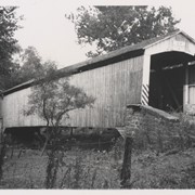
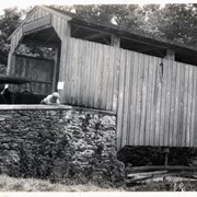
Description
Israel Sensenig's covered bridge near Martindale in East Earl Township. State supervised on road LR 36013, built 1857, single span 65 feet long.
Date Range
1950
Creator
Gaintner, Jay Richard
Storage Location
LancasterHistory, Lancaster, PA
People
Sensenig, Israel
Subcategory
Documentary Artifact
Search Terms
Bridges
Covered bridges
Mills
Martindale, Earl Twp.
Conestoga River
Place
East Earl Twp.
Object Name
Print, Photographic
Print Size
8 x 10 inches
Object ID
A-11-01-03
Images
Less detail
More Like This
Permalink
Toggle Full Record
Print, Photographic
https://collections.lancasterhistory.org/en/permalink/b04af35f-f309-4205-92da-216891255561
Collection
Covered Bridge Album
Object ID
A-11-01-04
Date Range
1950
More detail
1 image
Object Name
Print, Photographic
Collection
Covered Bridge Album
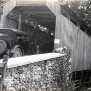
Description
Isaac Bear's Mill covered bridge, one mile southwest of Martindale in East Earl Township. County maintained on road T-674, built in 1876, single span 94 feet long.
Date Range
1950
Creator
Gaintner, Jay Richard
Storage Location
LancasterHistory, Lancaster, PA
People
Bear, Isaac
Subcategory
Documentary Artifact
Search Terms
Bridges
Covered bridges
Mills
Martindale, Earl Twp.
Conestoga River
Place
East Earl Twp.
Object Name
Print, Photographic
Print Size
8 x 10 inches
Object ID
A-11-01-04
Images
Less detail
More Like This
Permalink
Toggle Full Record
Print, Photographic
https://collections.lancasterhistory.org/en/permalink/b866941d-976f-46b6-9623-979665157629
Collection
Covered Bridge Album
Object ID
A-12-01-20
Date Range
1970
More detail
1 image
Object Name
Print, Photographic
Collection
Covered Bridge Album
Description
Red Run covered bridge near Hahnstown.
Date Range
1970
Creator
Krone, Herbert Brickley
Storage Location
LancasterHistory, Lancaster, PA
Subcategory
Documentary Artifact
Search Terms
Bridges
Covered bridges
Place
East Earl Twp.
Object Name
Print, Photographic
Print Size
3 x 5 inches
Object ID
A-12-01-20
Images
Less detail
More Like This
Permalink
Toggle Full Record
Print, Photographic
https://collections.lancasterhistory.org/en/permalink/e882cd79-c2d4-4428-b8a9-284860424138
Collection
Covered Bridge Album
Object ID
A-12-01-61
More detail
1 image
Object Name
Print, Photographic
Collection
Covered Bridge Album
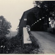
Description
Covered bridge over Muddy Creek near Terre Hill
Creator
Krone, Herbert Brickley
Storage Location
LancasterHistory, Lancaster, PA
Subcategory
Documentary Artifact
Search Terms
Bridges
Covered bridges
Muddy Creek
Place
East Earl Twp.
Object Name
Print, Photographic
Print Size
3 x 5 inches
Object ID
A-12-01-61
Images
Less detail
More Like This
Permalink
Toggle Full Record
Print, Photographic
https://collections.lancasterhistory.org/en/permalink/56e26152-bffb-4a25-b6f5-313649542259
Collection
General Collection
Object ID
1-20-04-55
More detail
1 image
Object Name
Print, Photographic
Collection
General Collection
Description
Covered bridge. Bridge number 5 over the Conestoga River, possibly at Weaverland.
Provenance
Photographs taken by Lancaster County during bridge repair work. Gift of Gordon Reed.
Year Range From
1920
Year Range To
1929
Storage Location
LancasterHistory, Lancaster, PA
Search Terms
Covered bridges
Weaverland, East Earl Twp.
Place
East Earl Twp.
Object Name
Print, Photographic
Print Size
3.25 x 5.5 inches
Object ID
1-20-04-55
Images
Less detail
More Like This
Permalink
Toggle Full Record
Print, Photographic
https://collections.lancasterhistory.org/en/permalink/e4025670-10d1-4001-9397-982771434042
Collection
General Collection
Object ID
1-20-04-56
More detail
1 image
Object Name
Print, Photographic
Collection
General Collection
Description
Covered bridge. Bridge number 5 over the Conestoga River, possibly at Weaverland.
Provenance
Photographs taken by Lancaster County during bridge repair work. Gift of Gordon Reed.
Year Range From
1920
Year Range To
1929
Storage Location
LancasterHistory, Lancaster, PA
Search Terms
Covered bridges
Weaverland, East Earl Twp.
Place
East Earl Twp.
Object Name
Print, Photographic
Print Size
3.25 x 5.5 inches
Object ID
1-20-04-56
Images
Less detail
More Like This
Permalink
Toggle Full Record
Print, Photographic
https://collections.lancasterhistory.org/en/permalink/2737595b-a4ab-4cd8-bf04-312030322618
Collection
General Collection
Object ID
1-20-04-78
More detail
1 image
Object Name
Print, Photographic
Collection
General Collection
Description
Bridge #1 over Muddy Creek, possibly on Dry Tavern Road.
Provenance
Photographs taken by Lancaster County during bridge repair work. Gift of Gordon Reed.
Year Range From
1920
Year Range To
1929
Storage Location
LancasterHistory, Lancaster, PA
Search Terms
Covered bridges
Muddy Creek
Place
East Earl Twp.
Object Name
Print, Photographic
Print Size
3.25 x 5.5 inches
Object ID
1-20-04-78
Images
Less detail
More Like This
Permalink
Toggle Full Record
Print, Photographic
https://collections.lancasterhistory.org/en/permalink/e4c092bb-80f1-42e6-90c9-930590656530
Collection
General Collection
Object ID
1-20-04-79
More detail
1 image
Object Name
Print, Photographic
Collection
General Collection
Description
Bridge #1 over Muddy Creek, possibly on Dry Tavern Road.
Provenance
Photographs taken by Lancaster County during bridge repair work. Gift of Gordon Reed.
Year Range From
1920
Year Range To
1929
Storage Location
LancasterHistory, Lancaster, PA
Search Terms
Covered bridges
Muddy Creek
Place
East Earl Twp.
Object Name
Print, Photographic
Print Size
3.25 x 5.5 inches
Object ID
1-20-04-79
Images
Less detail
More Like This
Permalink
21 records – page 1 of 3.
Prev
Next