It appears no script is enabled within your browser. Please enable JavaScript to use this site.
Skip header and navigation
Toggle navigation
Collections
Search
Help
Privacy
Your Selections:
0
Items
Staff Login
Revise Search
Revise Search
Revise search
Search
Data Source
Photographs
Library
Archives
1
×
Data Source
All
A
B
C
D
E
F
G
H
I
J
K
L
M
N
O
P
Q
R
S
T
U
V
W
X
Y
Z
Sort
By Count
Alphabetical
Filtered by
Filter
Loading...
Collection
Vincent Tortora Photograph Collection
39
General Collection
25
Lancaster 250 Collection
1
×
Collection
All
A
B
C
D
E
F
G
H
I
J
K
L
M
N
O
P
Q
R
S
T
U
V
W
X
Y
Z
Sort
By Count
Alphabetical
Filtered by
Filter
Loading...
Subject
Documentary Artifact
64
Covered bridges
60
Bridges
42
Conestoga Creek
4
Stone arch bridges
4
Bridges - Pennsylvania - Lancaster County.
2
Chickies Creek
2
Chiques Creek
2
Conestoga River
2
Creeks
2
Lancaster County (Pa.) - Maps.
2
Refton, Strasburg Twp.
2
More
×
Subject
All
A
B
C
D
E
F
G
H
I
J
K
L
M
N
O
P
Q
R
S
T
U
V
W
X
Y
Z
Sort
By Count
Alphabetical
Filtered by
Filter
Loading...
Name
Tortora, Vincent
39
Bixler, Robert Theodore
14
Bond, George Ross
5
Barton, Edwin Michelet.
1
Barton, R. Harold
1
Einolf, Albert L.
1
Horst, Mel
1
Lancaster County Planning Commission.
1
Mayo, R. S.
1
Sensenig, Israel
1
Shearer, Isaac
1
Smith, Elmer Lewis.
1
More
×
Name
All
A
B
C
D
E
F
G
H
I
J
K
L
M
N
O
P
Q
R
S
T
U
V
W
X
Y
Z
Sort
By Count
Alphabetical
Filtered by
Filter
Loading...
Place
East Hempfield Twp.
3
Warwick Twp.
3
Caernarvon Twp.
2
Earl Twp.
2
East Earl Twp.
2
West Hempfield Twp.
2
Colerain Twp.
1
Manheim Twp.
1
Paradise Twp.
1
Rapho Twp.
1
West Earl Twp.
1
×
Place
All
A
B
C
D
E
F
G
H
I
J
K
L
M
N
O
P
Q
R
S
T
U
V
W
X
Y
Z
Sort
By Count
Alphabetical
Filtered by
Filter
Loading...
Decade
1810s
1
1860s
2
1870s
3
1880s
6
1890s
31
1900s
39
1910s
76
1920s
283
1930s
64
1940s
8
1950s
169
1960s
1970s
67
1980s
8
1990s
34
2000s
72
2010s
2
×
Decade
All
A
B
C
D
E
F
G
H
I
J
K
L
M
N
O
P
Q
R
S
T
U
V
W
X
Y
Z
Sort
By Count
Alphabetical
Filtered by
Filter
Loading...
Material
Transparency, Slide
40
Print, Photographic
25
Text
5
Cartographic
2
×
Material
All
A
B
C
D
E
F
G
H
I
J
K
L
M
N
O
P
Q
R
S
T
U
V
W
X
Y
Z
Sort
By Count
Alphabetical
Filtered by
Filter
Loading...
Online Media
Image
65
PDF
1
×
Online Media
All
A
B
C
D
E
F
G
H
I
J
K
L
M
N
O
P
Q
R
S
T
U
V
W
X
Y
Z
Sort
By Count
Alphabetical
Filtered by
Filter
Loading...
Advanced Search
Help
topic:"Bridges"
Library
Photographs
1960s
Sorted by
Title
Sort by Relevance
Expand All
Collapse All
List View
Gallery View
Print
72 records – page 1 of 8.
Prev
Next
Toggle Full Record
The covered bridges of Columbia County, Pennsylvania
https://collections.lancasterhistory.org/en/permalink/lhdo4672
Author
Barton, Edwin Michelet.
Date of Publication
1962.
Call Number
624 B293
More detail
Author
Barton, Edwin Michelet.
Place of Publication
Bloomsburg, Pa
Publisher
Columbia County Historical Society,
Date of Publication
1962.
Physical Description
32 p. : ill., maps, plans ; 22 cm.
Series
The Columbian. Pamphlet series ; v. 1, no. 3
Notes
Bibliography: p. 27,31.
Subjects
Covered bridges - Pennsylvania - Columbia County.
Location
Lancaster History Library - Lancaster County
Call Number
624 B293
Less detail
More Like This
Permalink
Toggle Full Record
Covered bridges of Pennsylvania : a portfolio
https://collections.lancasterhistory.org/en/permalink/lhdo14011
Date of Publication
1962.
Call Number
624.2 C873a
More detail
Place of Publication
Downingtown, Pa
Publisher
Industrial Arts Department, Joint Senior High School, Downingtown, Pa. ,
Date of Publication
1962.
Physical Description
10 leaves in folder : ill. ; 24 cm.
Contents
Kutz's Mill Bridge, Lancaster Co.--Newcomer's Bridge--West of Homeville, Pa.--Soudersburg Bridge, Lancaster Co.--Landis Mill Bridge, Lancaster Co.--Dreibelbis Bridge, Berks Co.--Nolt's Point Mill Bridge, Near Oregon, Pa.--Valley Forge Bridge, Valley Forge Park--Wenger's Mill Bridge, Brownstown, Pa.--Kauffman's Distillery Bridge, Lancaster Co.--Clay's Bridge, Perry Co.
Subjects
Covered bridges - Pennsylvania
Location
Lancaster History Library - Book
Call Number
624.2 C873a
Less detail
More Like This
Permalink
Toggle Full Record
Covered bridges of Pennsylvania Dutchland
https://collections.lancasterhistory.org/en/permalink/lhdo4779
Author
Horst, Mel
Edition
Rev. ed.
Date of Publication
l963, c1960
Call Number
624 H819
More detail
Responsibility
Photography by Mel Horst ; Text by Elmer L. Smith.
Author
Horst, Mel
Edition
Rev. ed.
Place of Publication
Witmer, Pa
Publisher
Applied Arts,
Date of Publication
l963, c1960
Physical Description
42 p. : ill. (mostly photographs) ; 29 cm.
Notes
Colored photographs on cover.
Subjects
Covered bridges - Pennsylvania.
Additional Author
Smith, Elmer Lewis.
Location
Lancaster History Library - Lancaster County
Call Number
624 H819
Less detail
More Like This
Permalink
Toggle Full Record
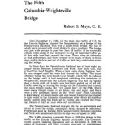
The fifth Columbia-Wrightsville Bridge
https://collections.lancasterhistory.org/en/permalink/lhdo784
Author
Mayo, R. S.
Date of Publication
1969.
More detail
1 document
Responsibility
by Robert S. Mayo, C.E.
Author
Mayo, R. S.
Place of Publication
Lancaster, Pa
Publisher
Lancaster County Historical Society,
Date of Publication
1969.
Physical Description
[26]-33 p. : ill. ; 23 cm.
Series
Journal of the Lancaster County Historical Society ; v. 73, no. 1
Subjects
Bridges - Pennsylvania - Lancaster County.
Bridges
Columbia-Wrightsville Bridge (Lancaster County, Pa.)
Contained In
Journal of the Lancaster County Historical Society. Volume 73, number 1 (1969), p. 26-33Lancaster History Library - Journal974.9 L245 v.73
Documents
edit_vol73no1pp26_33.pdf
Read PDF
Download PDF
Less detail
More Like This
Permalink
Toggle Full Record
Lancaster County, Penna. : garden spot of America
https://collections.lancasterhistory.org/en/permalink/lhdo15746
Corporate Author
Lancaster County Planning Commission.
Date of Publication
1960.
Call Number
974.815 LACO 521Oversize
More detail
Responsibility
prepared by the Lancaster County Planning Commission.
Corporate Author
Lancaster County Planning Commission.
Place of Publication
[Lancaster, Pa.]
Publisher
Lancaster County Planning Commission,
Date of Publication
1960.
Physical Description
1 map ; 90 x 105 cm.
Notes
Smaller map call number MAP 900 111
Shows covered bridges.
Indexed for points of interest.
Subjects
Covered bridges - Pennsylvania - Lancaster County - Maps.
Lancaster County (Pa.) - Maps.
Location
Lancaster History Library - Map
Call Number
974.815 LACO 521Oversize
Less detail
More Like This
Permalink
Toggle Full Record
Lancaster County, Penna. : "garden spot of America"
https://collections.lancasterhistory.org/en/permalink/lhdo5476
Date of Publication
1960.
Call Number
974.815 LACO 111
More detail
Responsibility
prepared by the Lancaster County Planning Commission.
Place of Publication
Lancaster, Pa
Publisher
Lancaster County Planning Commission ,
Date of Publication
1960.
Physical Description
1 map ; 50 x 54 cm.
Notes
Shows covered bridges.
Indexed for points of interest.
Subjects
Covered bridges - Pennsylvania - Lancaster County
Lancaster County (Pa.) - Maps.
Location
Lancaster History Library - Map
Call Number
974.815 LACO 111
Less detail
More Like This
Permalink
Toggle Full Record
Mills and bridges of Lancaster County
https://collections.lancasterhistory.org/en/permalink/lhdo14608
Author
Barton, R. Harold
Date of Publication
1967?
Call Number
725.4 B283
More detail
Responsibility
compiled by R. Harold Barton.
Author
Barton, R. Harold
Place of Publication
Typescript
Date of Publication
1967?
Physical Description
5 v. : photos ; 29 cm.
Notes
Related material in MG-15, Archives North.
Index (v.5) arranged by mill name, location, stream.
Subjects
Bridges - Pennsylvania - Lancaster County.
Watermills - Pennsylvania - Lancaster County.
Mills and millwork - Pennsylvania - Lancaster County.
Location
Lancaster History Library - Lancaster County
Call Number
725.4 B283
Less detail
More Like This
Permalink
Toggle Full Record
Print, Photographic
https://collections.lancasterhistory.org/en/permalink/0f2e2d3a-85a9-4176-8f02-358810268710
Collection
General Collection
Object ID
1-09-05-33
Date Range
c. 1960
More detail
1 image
Object Name
Print, Photographic
Collection
General Collection
Description
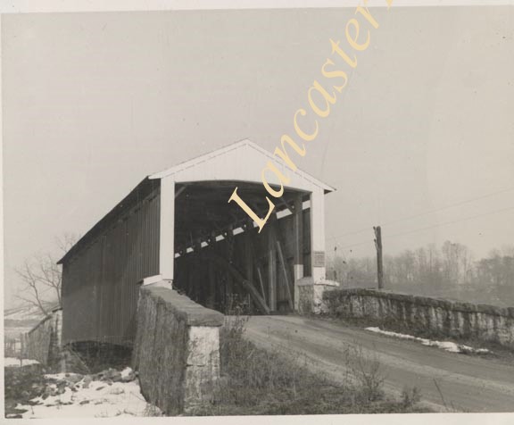
Covered bridge of Conestoga Creek northwest of Long's Park
Provenance
digital image only - original owned by Milton Haldeman
Date Range
c. 1960
Storage Location
LancasterHistory, Lancaster, PA
Subcategory
Documentary Artifact
Search Terms
Covered bridges
Conestoga Creek
Long's Park
Place
East Hempfield Twp.
Object Name
Print, Photographic
Condition
Good
Object ID
1-09-05-33
Images
Less detail
More Like This
Permalink
Toggle Full Record
Print, Photographic
https://collections.lancasterhistory.org/en/permalink/b9948b29-6cca-41ad-9dee-433868174962
Collection
General Collection
Object ID
1-09-05-34
Date Range
c. 1960
More detail
1 image
Object Name
Print, Photographic
Collection
General Collection
Description
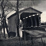
Poole Forge Bridge, west of Churchtown in Caernarvon Township on starting branch if Conestoga Creek. 99 feet long, built 1859.
Provenance
digital image only - original owned by Milton Haldeman
Date Range
c. 1960
Storage Location
LancasterHistory, Lancaster, PA
Subcategory
Documentary Artifact
Search Terms
Poole Forge
Churchtown, Caernarvon Twp.
Conestoga Creek
Covered bridges
Place
Caernarvon Twp.
Object Name
Print, Photographic
Condition
Good
Object ID
1-09-05-34
Images
Less detail
More Like This
Permalink
Toggle Full Record
Print, Photographic
https://collections.lancasterhistory.org/en/permalink/9ed35f2b-dd2f-495d-a730-130851132780
Collection
General Collection
Object ID
1-09-05-35
Date Range
c. 1960
More detail
1 image
Object Name
Print, Photographic
Collection
General Collection
Description
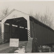
Isaac Shearer's Mill bridge, one mile north of Goodville in Caernarvon Township on starting branch of the Conestoga Creek. 8 feet long, built in 1878.
Provenance
digital image only - original owned by Milton Haldeman
Date Range
c. 1960
Storage Location
LancasterHistory, Lancaster, PA
People
Shearer, Isaac
Subcategory
Documentary Artifact
Search Terms
Shearer's Mill
Goodville, East Earl Twp.
Conestoga Creek
Covered bridges
Place
Caernarvon Twp.
Object Name
Print, Photographic
Condition
Good
Object ID
1-09-05-35
Images
Less detail
More Like This
Permalink
72 records – page 1 of 8.
Prev
Next