Skip header and navigation

Revise Search

53 records – page 1 of 6.

Collection
General Collection
Object ID
1-19-01-39
Date Range
c. 1930
  1 image  
Object Name
Negative
Collection
General Collection
Description
Covered bridge over the Conestoga Creek at Poole Forge.
Provenance
Transferred from the Bob Swartz Collection at the Lower Merion Historical Society, May 6, 2014.
Date Range
c. 1930
Creator
Kurtz, Howard G. Sr.
Storage Location
LancasterHistory, Lancaster, PA
Search Terms
Covered bridges
Poole Forge Bridge
Conestoga River
Conestoga Creek
Place
Caernarvon Twp.
Object Name
Negative
Film Size
3 x 4.75 inches
Object ID
1-19-01-39
Images
Less detail
Collection
General Collection
Title
Pinetown Covered Bridge
Object ID
1-21-03-32
Date Range
24 October 1958
  1 image  
Object Name
Print, Photographic
Collection
General Collection
Title
Pinetown Covered Bridge
Description
Pinetown covered bridge
Date Range
24 October 1958
Creator
Bond, George Ross
Storage Location
LancasterHistory, Lancaster, PA
Storage Room
Archives West
People
Bond, G. Ross
Subject
Photographs
Classification
1-21-03-32
Search Terms
Covered bridges
Pinetown covered bridge
Conestoga Creek
Lititz Run
Place
Manheim Twp.
Object Name
Print, Photographic
Original or Copy
Original
Print Size
4 x 5 inches
Dimention Details
Photograph is glued to black paper
Object ID
1-21-03-32
Credit
Courtesy of LancasterHistory, Lancaster, Pennsylvania
Images
Less detail
Collection
General Collection
Object ID
2-04-04-11
  1 image  
Object Name
Print, Photographic
Collection
General Collection
Description
Bridge over Conestoga Creek, built 1841 by Jacob Huber, between Pequea and Manor Townships.
Storage Location
LancasterHistory, Lancaster, PA
People
Huber, Jacob
Subcategory
Documentary Artifact
Search Terms
Covered bridges
Conestoga Creek
Place
Pequea Twp.
Object Name
Print, Photographic
Print Size
10.5 x 8.5 inches
Object ID
2-04-04-11
Images
Less detail
Collection
General Collection
Object ID
2-04-04-18
  1 image  
Object Name
Print, Photographic
Collection
General Collection
Description
Hanging footbridge over the Conestoga Creek beyond Bushong's Mill
Storage Location
LancasterHistory, Lancaster, PA
Subcategory
Documentary Artifact
Search Terms
Footbridges
Conestoga Creek
Bushong's Mill
Place
Upper Leacock Twp.
Object Name
Print, Photographic
Print Size
6.5 x 5.5 inches
Object ID
2-04-04-18
Images
Less detail
Collection
General Collection
Title
Landis Mill Covered Bridge
Object ID
1-21-03-59
Date Range
22 March 1962
  1 image  
Object Name
Print, Photographic
Collection
General Collection
Title
Landis Mill Covered Bridge
Description
Covered bridge near Landis Mill
Date Range
22 March 1962
Storage Location
LancasterHistory, Lancaster, PA
Storage Room
Archives West
People
Bond, G. Ross
Subject
Photographs
Classification
1-21-03-59
Search Terms
Mills
Covered bridges
Landis Mill Covered Bridge
Landis Mill
Little Conestoga Creek
Place
East Hempfield Twp.
Object Name
Print, Photographic
Original or Copy
Original
Print Size
4 x 5 inches
Dimention Details
Photograph is glued to black paper
Object ID
1-21-03-59
Credit
Courtesy of LancasterHistory, Lancaster, Pennsylvania
Images
Less detail
Collection
General Collection
Object ID
1-09-03-81
Date Range
July 1956
  1 image  
Object Name
Print, Photographic
Collection
General Collection
Description
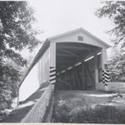
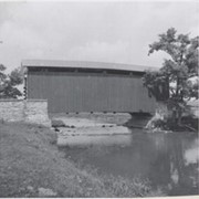
Covered bridge across the Conestoga Creek south of Oregon. Photo is identified as Raub's bridge, but is better known as Pinetown Bridge or Nolt's Point covered bridge.
Provenance
Lancaster County covered bridge photos taken by M. E. Schroll and Kathryn L. Sauder taken between 1956 and 1958.
Date Range
July 1956
Storage Location
LancasterHistory, Lancaster, PA
Subcategory
Documentary Artifact
Search Terms
Covered bridges
Conestoga Creek
Pinetown, Upper Leacock Twp.
Place
Manheim Twp.
Object Name
Print, Photographic
Print Size
3.5 x 3.5 inches
Condition
Good
Object ID
1-09-03-81
Images
Less detail
Collection
General Collection
Object ID
1-09-03-82
Date Range
August 5, 1958
  1 image  
Object Name
Print, Photographic
Collection
General Collection
Description
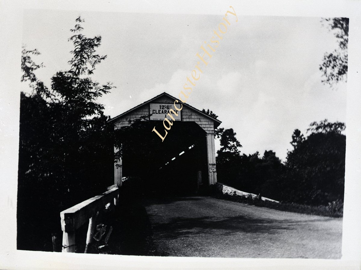
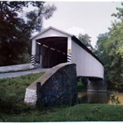
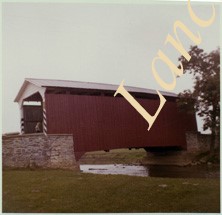
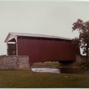
On the Conestoga Creek, Pinetown Road, south of Oregon. Bridge is identified as Raub's bridge but is better known as Pinetown Bridge or Nolt's Point covered bridge.
Provenance
Lancaster County covered bridge photos taken by M. E. Schroll and Kathryn L. Sauder taken between 1956 and 1958.
Date Range
August 5, 1958
Storage Location
LancasterHistory, Lancaster, PA
Subcategory
Documentary Artifact
Search Terms
Conestoga Creek
Covered bridges
Pinetown, Upper Leacock Twp.
Place
Manheim Twp.
Object Name
Print, Photographic
Print Size
3.5 x 3.5 inches
Condition
Good
Object ID
1-09-03-82
Images
Less detail
Collection
General Collection
Object ID
1-09-04-08
Date Range
July 1956
  1 image  
Object Name
Print, Photographic
Collection
General Collection
Description
Covered bridge on the Little Conestoga Creek, a short distance north of Oreville.
Provenance
Lancaster County covered bridge photos taken by M. E. Schroll and Kathryn L. Sauder taken between 1956 and 1958.
Date Range
July 1956
Storage Location
LancasterHistory, Lancaster, PA
Subcategory
Documentary Artifact
Search Terms
Oreville, East Hempfield Twp.
Little Conestoga Creek
Covered bridges
Place
East Hempfield Twp.
Object Name
Print, Photographic
Print Size
3.5 x 4.5 inches
Condition
Good
Object ID
1-09-04-08
Images
Less detail
Collection
General Collection
Object ID
1-09-04-09
Date Range
August 12, 1958
  1 image  
Object Name
Print, Photographic
Collection
General Collection
Description
Covered bridge on the Little Conestoga Creek north of Oreville.
Provenance
Lancaster County covered bridge photos taken by M. E. Schroll and Kathryn L. Sauder taken between 1956 and 1958.
Date Range
August 12, 1958
Storage Location
LancasterHistory, Lancaster, PA
Subcategory
Documentary Artifact
Search Terms
Covered bridges
Little Conestoga Creek
Oreville, East Hempfield Twp.
Place
East Hempfield Twp.
Object Name
Print, Photographic
Print Size
3.5 x 4.5 inches
Condition
Good
Object ID
1-09-04-09
Images
Less detail
Collection
General Collection
Object ID
1-09-04-11
Date Range
August 13, 1958
  1 image  
Object Name
Print, Photographic
Collection
General Collection
Description
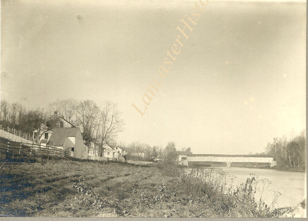
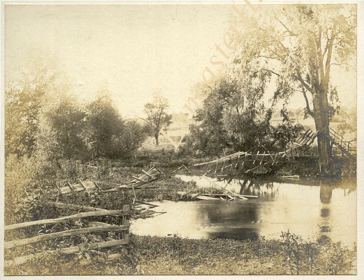
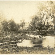
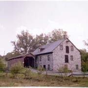
Covered bridge on the Little Conestoga Creek south of Maple Grove at Stoneroads Mill. This bridge was replaced and is the first privately owned bridge in county. George Mann, owner. Located between Lancaster and Manor townships.
Provenance
Lancaster County covered bridge photos taken by M. E. Schroll and Kathryn L. Sauder taken between 1956 and 1958.
Date Range
August 13, 1958
Storage Location
LancasterHistory, Lancaster, PA
People
Mann, George
Subcategory
Documentary Artifact
Search Terms
Covered bridges
Little Conestoga Creek
Maple Grove
Stoneroad's Mill
Lancaster Twp.
Manor Twp.
Object Name
Print, Photographic
Print Size
3.5 x 4.5 inches
Condition
Good
Object ID
1-09-04-11
Images
Less detail

53 records – page 1 of 6.