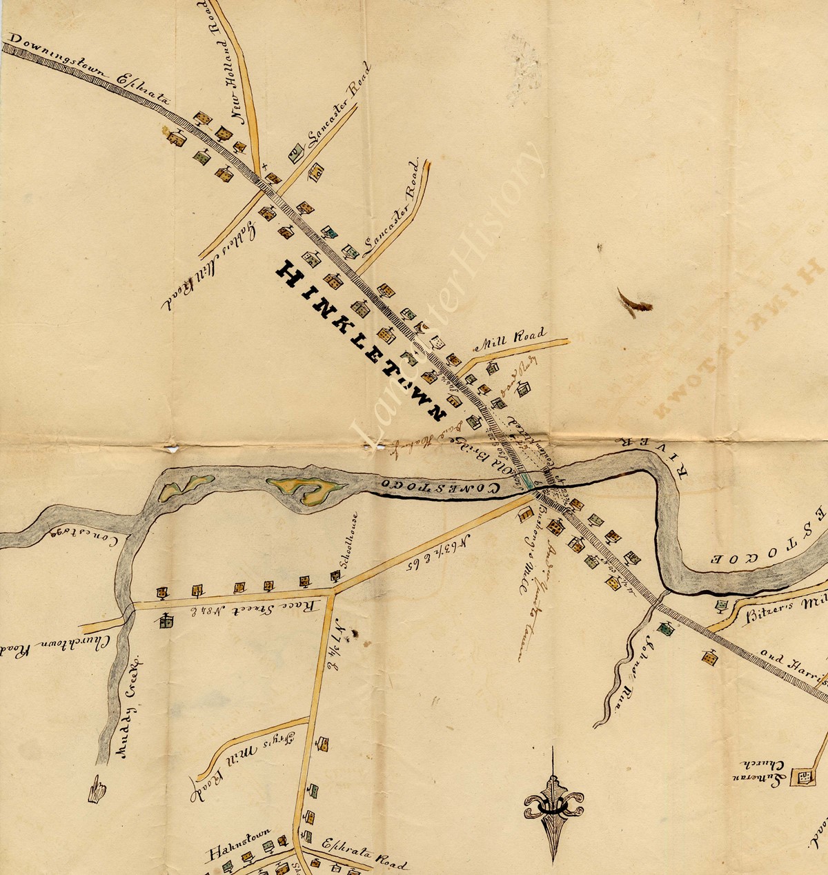
Reproduction of the Conestoga Navigation Company Map
Description
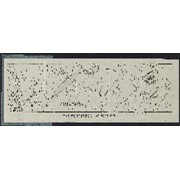
Reproduction of the Conestoga Navigation Company Map, showing early canal and locks along the Conestoga River from Lancaster to the Susquehanna River at Safe Harbor, circa 1840. The water power at each lock is noted, as well as daily water flow. Also shown are Lancaster, Millerstown, Indian Town, Safe Harbor, Turkey Hill, the names of the waterways, railroad, roads, and Lancaster City Water Works.
Conestoga Navigation Company and Related Materials Collection (MG0270)
George Steinman Papers, Series 1 (MG0184_S01) https://collections.lancasterhistory.org/en/permalink/786b3ffc-7908-40de-9362-817467455650
George Steinman Papers, Series 2 (MG0184_S02) https://collections.lancasterhistory.org/en/permalink/6c7e11c6-f3ca-469c-891a-145832196710
Notes
Preferred Citation: Title or description of item, date (day, month, year), George Steinman Papers (MG0184), Series 2, Object ID, LancasterHistory, Lancaster, Pennsylvania. URL if applicable. Date accessed (day, month, year).
Access Conditions / Restrictions
Please use digital images and transcriptions when available. Original documents may be used by appointment--contact Research@LancasterHistory.org prior to visit.
Copyright
Images have been provided for research purposes only. Please contact Research@LancasterHistory.org for a high-resolution image and permission to publish.
LancasterHistory retains the rights to the digital images and content presented. The doctrine of fair use allows limited use of copyrighted material without permission from the copyright holder. Fair use includes comment, criticism, teaching, and private scholarship. Any images and data downloaded, printed or photocopied for these purposes should provide a citation. All other uses beyond those allowed by fair use require written permission.
Permission for reproduction and/or publication must be obtained in writing from LancasterHistory. Persons wishing to publish any material from this site must assume all responsibility for identifying and satisfying any claimants of copyright or other use restrictions. Publication fees may apply.
Credit
Courtesy of LancasterHistory, Lancaster, Pennsylvania.
Other Numbers
MG-184, Series 2
Other Number
MG-184, Series 2, Folder 43, Insert 1, Item 1
Classification
MG0184
Description Level
Item
Custodial History
Added to database 25 March 2024.
Digitization of this document was funded by the Pennsylvania Historical and Museum Commission, PHMC Appl ID # C980002119, 2021-2024.
Map of march from Camp Dick Robinson, Kentucky to Harrodsburg, Kentucky
Description
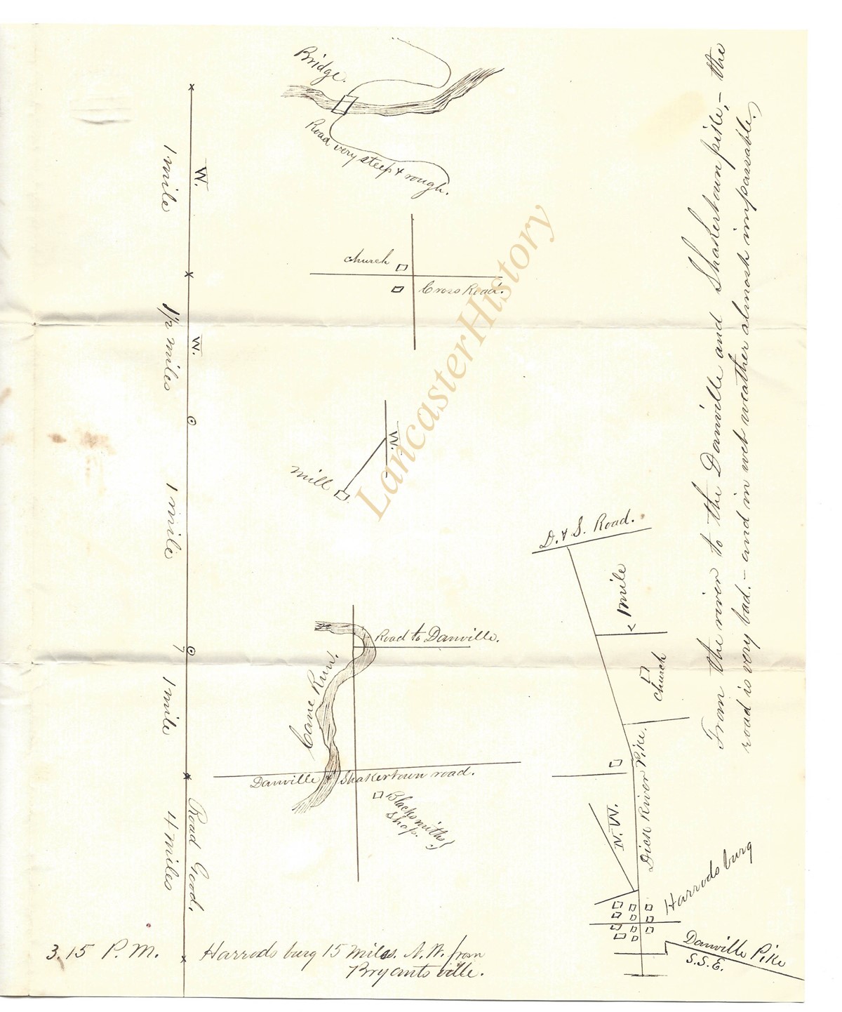
Handdrawn map of the march of a detachment of the 36th Massachusetts volunteers from Camp Dick Robinson, Kentucky to Harrodsburg, Kentucky. Notations include time stamps, mileage numbers, and various notes regarding conditions encountered on the march.
Admin/Biographical History
Thomas Welsh (1824-1863) was a Lancaster County native (born and raised in Columbia), who rose from hardscrabble origins to local fame, first as a Mexican War hero, and then as a brigadier general during the Civil War. He was well known and well respected as a no nonsense officer, for his leadership and gallantry in battle, for his dedication to the service of his country, and for his concern for the welfare of his men. See MG0828 for more biographical information.
Provenance: Passed down through the family, Blanton Charles Welsh to Emilie Benson (Welsh) Wiggin to Nancy Jane (Wiggin) Townsend. Acquired from: Chuck Townsend, Knoxville, Tennessee, 2016/05/15.
Access Conditions / Restrictions
Please use digital images and transcriptions when available. Original documents may be used by appointment. Please contact research@lancasterhistory.org at least two weeks prior to visit.
Copyright
Images have been provided for research purposes only. Please contact research@lancasterhistory.org for a high-resolution image and permission to publish.
LancasterHistory retains the rights to the digital images and content presented. The doctrine of fair use allows limited use of copyrighted material without permission from the copyright holder. Fair use includes comment, criticism, teaching, and private scholarship. Any images and data downloaded, printed or photocopied for these purposes should provide a citation. All other uses beyond those allowed by fair use require written permission.
Permission for reproduction and/or publication must be obtained in writing from LancasterHistory. Some items are photocopies from other collections--researchers must obtain permission for reproduction and publication from the owner of the original material.
Persons wishing to publish any material from this site must assume all responsibility for identifying and satisfying any claimants of copyright or other use restrictions. Publication fees may apply.
Credit
Courtesy of LancasterHistory, Lancaster, Pennsylvania.
George Steinman Papers, Series 1 (MG0184_S01) https://collections.lancasterhistory.org/en/permalink/786b3ffc-7908-40de-9362-817467455650
George Steinman Papers, Series 2 (MG0184_S02) https://collections.lancasterhistory.org/en/permalink/6c7e11c6-f3ca-469c-891a-145832196710
Notes
Preferred Citation: Title or description of item, date (day, month, year), George Steinman Papers (MG0184), Series 2, Object ID, LancasterHistory, Lancaster, Pennsylvania. URL if applicable. Date accessed (day, month, year).
Access Conditions / Restrictions
Please use digital images and transcriptions when available. Original documents may be used by appointment--contact Research@LancasterHistory.org prior to visit.
Copyright
Images have been provided for research purposes only. Please contact Research@LancasterHistory.org for a high-resolution image and permission to publish.
LancasterHistory retains the rights to the digital images and content presented. The doctrine of fair use allows limited use of copyrighted material without permission from the copyright holder. Fair use includes comment, criticism, teaching, and private scholarship. Any images and data downloaded, printed or photocopied for these purposes should provide a citation. All other uses beyond those allowed by fair use require written permission.
Permission for reproduction and/or publication must be obtained in writing from LancasterHistory. Persons wishing to publish any material from this site must assume all responsibility for identifying and satisfying any claimants of copyright or other use restrictions. Publication fees may apply.
Credit
Courtesy of LancasterHistory, Lancaster, Pennsylvania.
Other Numbers
MG-184, Series 2
Other Number
MG-184, Series 2, Folder 16, Item 6
Classification
MG0184
Description Level
Item
Custodial History
Added to database 12 September 2023.
Digitization of this document was funded by the Pennsylvania Historical and Museum Commission, PHMC Appl ID # C980002119, 2021-2024.
George Steinman Papers, Series 1 (MG0184_S01) https://collections.lancasterhistory.org/en/permalink/786b3ffc-7908-40de-9362-817467455650
George Steinman Papers, Series 2 (MG0184_S02) https://collections.lancasterhistory.org/en/permalink/6c7e11c6-f3ca-469c-891a-145832196710
Notes
Preferred Citation: Title or description of item, date (day, month, year), George Steinman Papers (MG0184), Series 2, Object ID, LancasterHistory, Lancaster, Pennsylvania. URL if applicable. Date accessed (day, month, year).
Access Conditions / Restrictions
Please use digital images and transcriptions when available. Original documents may be used by appointment--contact Research@LancasterHistory.org prior to visit.
Copyright
Images have been provided for research purposes only. Please contact Research@LancasterHistory.org for a high-resolution image and permission to publish.
LancasterHistory retains the rights to the digital images and content presented. The doctrine of fair use allows limited use of copyrighted material without permission from the copyright holder. Fair use includes comment, criticism, teaching, and private scholarship. Any images and data downloaded, printed or photocopied for these purposes should provide a citation. All other uses beyond those allowed by fair use require written permission.
Permission for reproduction and/or publication must be obtained in writing from LancasterHistory. Persons wishing to publish any material from this site must assume all responsibility for identifying and satisfying any claimants of copyright or other use restrictions. Publication fees may apply.
Credit
Courtesy of LancasterHistory, Lancaster, Pennsylvania.
Other Numbers
MG-184, Series 2
Other Number
MG-184, Series 2, Folder 16, Item 7
Classification
MG0184
Description Level
Item
Custodial History
Added to database 29 November 2023.
Digitization of this document was funded by the Pennsylvania Historical and Museum Commission, PHMC Appl ID # C980002119, 2021-2024.