- Collection
- Bridge Information Compiled by Benjamin Weaver
- Title
- Bridge Information Compiled by Benjamin Weaver
- Object ID
- MG0587
- Date Range
- 1960s-1970s
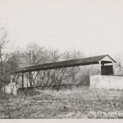
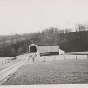
Bridges
Calamus Run
Cocalico Creek
Conewago Creek
Conowingo Creek
Conoy Creek
Coon Creek
East Octoraro Creek
Finding aids
Hammer Creek
Little Chiques Creek
Little Conestoga Creek
Manuscript groups
Mill Creek
Muddy Creek
Pequea Creek
Peters Creek
West Octoraro Creek
Related Materials: Mr. Weaver