It appears no script is enabled within your browser. Please enable JavaScript to use this site.
Skip header and navigation
Toggle navigation
Collections
Search
Help
Privacy
Your Selections:
0
Items
Staff Login
Revise Search
Revise Search
Revise search
Search
Data Source
Photographs
17
×
Data Source
All
A
B
C
D
E
F
G
H
I
J
K
L
M
N
O
P
Q
R
S
T
U
V
W
X
Y
Z
Sort
By Count
Alphabetical
Filtered by
Filter
Loading...
Collection
Liquor License Papers
101
Renunciations
58
Bridge Records
47
Collateral Appraisements
27
Barton Mill Photograph Collection
20
General Collection
Constables' and Detectives' Bonds
11
Covered Bridge Safari Album
6
Mechanics' Liens
5
Churches Album
3
Gerald High Schoolhouse Photo Album
Leon Landis Album 6
3
More
×
Collection
All
A
B
C
D
E
F
G
H
I
J
K
L
M
N
O
P
Q
R
S
T
U
V
W
X
Y
Z
Sort
By Count
Alphabetical
Filtered by
Filter
Loading...
Subject
Documentary Artifact
13
Bridges
7
Covered bridges
6
Cocalico Creek
5
Conestoga River
5
West Earl Twp.
5
Creeks
4
Log Cabin Road
3
Miniature golf
3
Recreation
3
Rose Hill Bridge
3
Schaum's Corner, West Earl Twp.
3
More
×
Subject
All
A
B
C
D
E
F
G
H
I
J
K
L
M
N
O
P
Q
R
S
T
U
V
W
X
Y
Z
Sort
By Count
Alphabetical
Filtered by
Filter
Loading...
Name
Weaver, Carl
1
Wolf, J. H.
1
Wolf, L. C.
1
×
Name
All
A
B
C
D
E
F
G
H
I
J
K
L
M
N
O
P
Q
R
S
T
U
V
W
X
Y
Z
Sort
By Count
Alphabetical
Filtered by
Filter
Loading...
Place
West Earl Twp.
12
Warwick Twp.
1
×
Place
All
A
B
C
D
E
F
G
H
I
J
K
L
M
N
O
P
Q
R
S
T
U
V
W
X
Y
Z
Sort
By Count
Alphabetical
Filtered by
Filter
Loading...
Decade
1910s
1
1920s
4
1930s
3
1950s
4
1990s
3
×
Decade
All
A
B
C
D
E
F
G
H
I
J
K
L
M
N
O
P
Q
R
S
T
U
V
W
X
Y
Z
Sort
By Count
Alphabetical
Filtered by
Filter
Loading...
Material
Print, Photographic
17
×
Material
All
A
B
C
D
E
F
G
H
I
J
K
L
M
N
O
P
Q
R
S
T
U
V
W
X
Y
Z
Sort
By Count
Alphabetical
Filtered by
Filter
Loading...
Online Media
Image
17
×
Online Media
All
A
B
C
D
E
F
G
H
I
J
K
L
M
N
O
P
Q
R
S
T
U
V
W
X
Y
Z
Sort
By Count
Alphabetical
Filtered by
Filter
Loading...
Advanced Search
Help
topic:"West Earl Twp."
Gerald High Schoolhouse Photo Album
General Collection
Sorted by
Title
Sort by Relevance
Expand All
Collapse All
List View
Gallery View
Print
17 records – page 1 of 2.
Prev
Next
Toggle Full Record
Print, Photographic
https://collections.lancasterhistory.org/en/permalink/62f55310-8ff3-4faa-91ab-411424121900
Collection
General Collection
Object ID
2-02-02-45
Date Range
c. 1910
More detail
1 image
Object Name
Print, Photographic
Collection
General Collection
Description
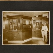
Brownstown National Bank on its opening day. At left is cashier, J. H. Wolf and at right is a customer possibly identified as Mr. Shiffer. Could also be first customer, L. C. Wolf.
Date Range
c. 1910
Storage Location
LancasterHistory, Lancaster, PA
People
Wolf, J. H.
Wolf, L. C.
Subcategory
Documentary Artifact
Search Terms
Banks
Financial institutions
Brownstown, West Earl Twp.
Place
West Earl Twp.
Object Name
Print, Photographic
Print Size
10 x 8 inches
Object ID
2-02-02-45
Other Number
L81-237
Images
Less detail
More Like This
Permalink
Toggle Full Record
Print, Photographic
https://collections.lancasterhistory.org/en/permalink/5e93a77a-b151-4c88-95ba-423210273245
Collection
General Collection
Object ID
1-09-03-79
Date Range
August 13, 1958
More detail
1 image
Object Name
Print, Photographic
Collection
General Collection
Description
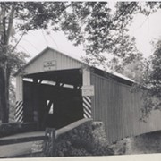
Bitzer's Mill covered bridge, also called Eberly's Cider Mill covered bridge, on the Conestoga River north of Fairmount.
Provenance
Lancaster County covered bridge photos taken by M. E. Schroll and Kathryn L. Sauder taken between 1956 and 1958.
Date Range
August 13, 1958
Storage Location
LancasterHistory, Lancaster, PA
Subcategory
Documentary Artifact
Search Terms
Bitzer's Mill
Covered bridges
Eberly's Cider Mill
Conestoga River
Fairmount, West Earl Twp.
Place
West Earl Twp.
Object Name
Print, Photographic
Print Size
3.5 x 3.5 inches
Condition
Good
Object ID
1-09-03-79
Images
Less detail
More Like This
Permalink
Toggle Full Record
Print, Photographic
https://collections.lancasterhistory.org/en/permalink/b2bafc66-5a5c-4223-af82-341496793242
Collection
General Collection
Object ID
1-09-03-80
Date Range
August 13, 1958
More detail
1 image
Object Name
Print, Photographic
Collection
General Collection
Description
Bitzer's Mill covered bridge, also called Eberly's Cider Mill covered bridge, on the Conestoga River north of Fairmount.
Provenance
Lancaster County covered bridge photos taken by M. E. Schroll and Kathryn L. Sauder taken between 1956 and 1958.
Date Range
August 13, 1958
Storage Location
LancasterHistory, Lancaster, PA
Subcategory
Documentary Artifact
Search Terms
Bitzer's Mill
Covered bridges
Eberly's Cider Mill
Conestoga River
Fairmount, West Earl Twp.
Place
West Earl Twp.
Object Name
Print, Photographic
Print Size
3.5 x 3.5 inches
Condition
Good
Object ID
1-09-03-80
Images
Less detail
More Like This
Permalink
Toggle Full Record
Print, Photographic
https://collections.lancasterhistory.org/en/permalink/69f030a4-faf6-466e-a4ad-467078315846
Collection
General Collection
Object ID
1-09-04-02
Date Range
July 1956
More detail
1 image
Object Name
Print, Photographic
Collection
General Collection
Description
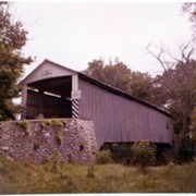
Zook's Mill covered bridge across the Cocalico Creek south of Akron between West Earl and Warwick townships.
Provenance
Lancaster County covered bridge photos taken by M. E. Schroll and Kathryn L. Sauder taken between 1956 and 1958.
Date Range
July 1956
Storage Location
LancasterHistory, Lancaster, PA
Subcategory
Documentary Artifact
Search Terms
Zook's Mill
Covered bridges
Cocalico Creek
Akron, Pennsylvania
West Earl Twp.
Warwick Twp.
Creeks
Rose Hill Bridge
Object Name
Print, Photographic
Print Size
3.5 x 4.5 inches
Condition
Good
Object ID
1-09-04-02
Images
Less detail
More Like This
Permalink
Toggle Full Record
Print, Photographic
https://collections.lancasterhistory.org/en/permalink/4bbec65e-0210-44c9-9eec-452372049972
Collection
General Collection
Object ID
1-09-04-03
Date Range
August 5, 1958
More detail
1 image
Object Name
Print, Photographic
Collection
General Collection
Description
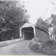
Zook's Mill covered bridge on the Cocalico Creek on Log Cabin Road west of Brownstown between West Earl and Warwick townships.
Provenance
Lancaster County covered bridge photos taken by M. E. Schroll and Kathryn L. Sauder taken between 1956 and 1958.
Date Range
August 5, 1958
Storage Location
LancasterHistory, Lancaster, PA
Subcategory
Documentary Artifact
Search Terms
Bridges
Brownstown, West Earl Twp.
Cocalico Creek
Covered bridges
Creeks
Log Cabin Road
Rose Hill Bridge
Warwick Twp.
West Earl Twp.
Zook's Mill
Object Name
Print, Photographic
Print Size
3.5 x 4.5 inches
Condition
Good
Object ID
1-09-04-03
Images
Less detail
More Like This
Permalink
Toggle Full Record
Print, Photographic
https://collections.lancasterhistory.org/en/permalink/d9669f8f-36db-4131-8743-553287594302
Collection
Gerald High Schoolhouse Photo Album
Object ID
GH-01-01-109
Date Range
1997
More detail
1 image
Object Name
Print, Photographic
Collection
Gerald High Schoolhouse Photo Album
Description
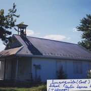
Sunnyside East School, Center Square Road, Talmage
Provenance
Gift of the widow of the late Gerald High. Digital images only.
Date Range
1997
Storage Location
LancasterHistory, Lancaster, PA
Subcategory
Documentary Artifact
Search Terms
Schoolhouses
Sunnyside East School
West Earl Twp
Place
West Earl Twp.
Object Name
Print, Photographic
Print Size
4 x 6 inches
Condition
Not Rated
Object ID
GH-01-01-109
Images
Less detail
More Like This
Permalink
Toggle Full Record
Print, Photographic
https://collections.lancasterhistory.org/en/permalink/ae510b6b-19f9-4812-9ff3-763000392164
Collection
Gerald High Schoolhouse Photo Album
Object ID
GH-01-01-110
Date Range
1997
More detail
1 image
Object Name
Print, Photographic
Collection
Gerald High Schoolhouse Photo Album
Description
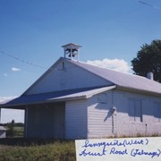
Sunnyside West School, possibly Forest Road, Talmage
Provenance
Gift of the widow of the late Gerald High. Digital images only.
Date Range
1997
Storage Location
LancasterHistory, Lancaster, PA
Subcategory
Documentary Artifact
Search Terms
Schoolhouses
Sunnyside West School
West Earl Twp
Place
West Earl Twp.
Object Name
Print, Photographic
Print Size
4 x 6 inches
Condition
Not Rated
Object ID
GH-01-01-110
Images
Less detail
More Like This
Permalink
Toggle Full Record
Print, Photographic
https://collections.lancasterhistory.org/en/permalink/28fb4e14-62dd-47d7-8e3e-153947462510
Collection
Gerald High Schoolhouse Photo Album
Object ID
GH-01-01-207
Date Range
1997
More detail
1 image
Object Name
Print, Photographic
Collection
Gerald High Schoolhouse Photo Album
Description
Farmersville High School, Farmersville
Provenance
Gift of the widow of the late Gerald High. Digital images only.
Date Range
1997
Storage Location
LancasterHistory, Lancaster, PA
Subcategory
Documentary Artifact
Search Terms
Schoolhouses
Farmersville High School
Farmersville, West Earl Twp.
Place
West Earl Twp.
Object Name
Print, Photographic
Print Size
4 x 6 inches
Condition
Not Rated
Object ID
GH-01-01-207
Images
Less detail
More Like This
Permalink
Toggle Full Record
Print, Photographic
https://collections.lancasterhistory.org/en/permalink/a461ca80-cdaf-43db-b3b2-094636121854
Collection
General Collection
Object ID
1-20-04-63
More detail
1 image
Object Name
Print, Photographic
Collection
General Collection
Description
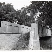
Bridge number 11 over the Conestoga River - at West Farmersville Road and Turtle Hill Road.
Provenance
Photographs taken by Lancaster County during bridge repair work. Gift of Gordon Reed.
Year Range From
1920
Year Range To
1929
Storage Location
LancasterHistory, Lancaster, PA
Search Terms
Bridges
Conestoga River
Farmersville, West Earl Twp.
Place
West Earl Twp.
Object Name
Print, Photographic
Print Size
3.25 x 5.5 inches
Object ID
1-20-04-63
Images
Less detail
More Like This
Permalink
Toggle Full Record
Print, Photographic
https://collections.lancasterhistory.org/en/permalink/1e280d11-9f8a-417f-a74c-261884900646
Collection
General Collection
Object ID
1-20-04-64
More detail
1 image
Object Name
Print, Photographic
Collection
General Collection
Description
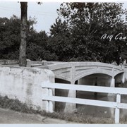
Bridge number 12 over the Conestoga River - possibly near Talmage
Provenance
Photographs taken by Lancaster County during bridge repair work. Gift of Gordon Reed.
Year Range From
1920
Year Range To
1929
Storage Location
LancasterHistory, Lancaster, PA
Search Terms
Bridges
Conestoga River
West Earl Twp
Place
West Earl Twp.
Object Name
Print, Photographic
Print Size
3.25 x 5.5 inches
Object ID
1-20-04-64
Images
Less detail
More Like This
Permalink
17 records – page 1 of 2.
Prev
Next