The Old Gulph Road
https://collections.lancasterhistory.org/en/permalink/lhdo13356
- Responsibility
- by Allen Evans.
- Author
- Evans, Allen
- Place of Publication
- [s.l
- Publisher
- s.n.]
- Date of Publication
- 1918.
- Notes
- Read at the meeting of the Numismatic and Antiquarian Society of Philadelphia, November 18, 1918.
- Subjects
- Montgomery County
- Chester County
- Lancaster County
- Roads - Pennsylvania
- Old Gulph Road (Montgomery County, Pa.)
- Old Gulph Road (Chester County, Pa.)
- Old Gulph Road (Lancaster County, Pa.)
- Pennsylvania - Transportation.
- Location
- Lancaster History Library - Book
- Call Number
- 386 E82
- Collection
- Bridge Records
- Title
- Bridge Records
- Object ID
- Bridge F0025 I011
- Date Range
- 1913
- Collection
- Bridge Records
- Title
- Bridge Records
- Date Range
- 1913
- Year
- 1913
- Storage Location
- LancasterHistory, Lancaster, PA
- Storage Room
- Archives West
- Storage Container
- Box 0001
- Subcategory
- Documentary Artifact
- Search Terms
- Beartown Road
- Bridges
- Caernarvon Twp.
- Conestoga Creek
- Creeks
- Honey Brook Road
- Mill Road
- Public notices
- Roads
- Place
- Caernarvon Twp.
- Object Name
- Notice, Legal
- Language
- English
- Condition
- Fair
- Object ID
- Bridge F0025 I011
- Box Number
- 001
- Additional Notes
- [Caernarvon Twp.]
- Location: On the Honey Brook Road, between the Beartown Road and the Mill Road.
- Document type: Public notice of viewers.
- 2 items, 2 pieces
- Access Conditions / Restrictions
- Request at Reference Desk; photocopy made by staff member.
- Classification
- RG 02-00 0324
- Description Level
- Item
- Collection
- Bridge Records
- Title
- Bridge Records
- Object ID
- Bridge F0025 I012
- Date Range
- 1913/09
- Collection
- Bridge Records
- Title
- Bridge Records
- Date Range
- 1913/09
- Year
- 1913
- Storage Location
- LancasterHistory, Lancaster, PA
- Storage Room
- Archives West
- Storage Container
- Box 0001
- Subcategory
- Documentary Artifact
- Search Terms
- Beartown Road
- Bridges
- Caernarvon Twp.
- Conestoga Creek
- Creeks
- Honey Brook Road
- Mill Road
- Orders
- Reports
- Roads
- Place
- Caernarvon Twp.
- Object Name
- Report
- Language
- English
- Condition
- Fair
- Object ID
- Bridge F0025 I012
- Box Number
- 001
- Additional Notes
- Court term: September 1913.
- Location: On the Honeybrook Road, between the Beartown Road and the Mill Road.
- Document type: Order and report of viewers.
- 4 items, 4 pieces
- Access Conditions / Restrictions
- Request at Reference Desk; photocopy made by staff member.
- Case Number
- 83.000
- Classification
- RG 02-00 0324
- Description Level
- Item
History of the Philadelphia and Lancaster Turnpike : the first long turnpike in the United States
https://collections.lancasterhistory.org/en/permalink/lhdo14878
- Responsibility
- Charles I. Landis.
- Author
- Landis, Charles Israel ,
- Place of Publication
- Philadelphia, Pa
- Publisher
- Historical Society of Pennsylvania ,
- Date of Publication
- 1918.
- Physical Description
- pp. 1-28 : ill. ; 23 cm.
- Notes
- In: Pennsylvania Magazine of History and Biography, v.42.
- This record provides a link to this resuorce on the publisher's official online repository.
- Subjects
- Philadelphia and Lancaster Turnpike Road Company.
- Toll roads - Pennsylvania.
- Philadelphia and Lancaster Turmpike Road.
Websites
History of the Philadelphia and Lancaster Turnpike : the first long turnpike in the United States
https://collections.lancasterhistory.org/en/permalink/lhdo14879
- Author
- Landis, Charles Israel ,
- Date of Publication
- 1919.
- Call Number
- 905.748 HSP, vols. 42 & 43
6 websites
- Responsibility
- Charles I. Landis.
- Author
- Landis, Charles Israel ,
- Place of Publication
- Philadelphia, Pa
- Publisher
- Historical Society of Pennsylvania ,
- Date of Publication
- 1919.
- Physical Description
- pp. 84-90 , 182-190 : ill. ; 23 cm.
- Notes
- This article was serialized across several issues. This record provides links to each installment. Most of the links are from the publisher's official online repository, although two parts were only available on the HathiTrust online depository.
- In: Pennsylvania Magazine of History and Biography, volumes 42 (p. 1-28, 127-140, 235-258, & 358-360) & 43 (p. 84-90 and 182-190).
- Summary
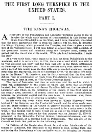
- The author writes about the " Kings Highway ", the first road from Philadelphia to the Lancaster area, and he then recounts the building of the Philadelphia to Lancaster Turnpike. The third part of his article describes the various taverns and points of interest along the Lancaster County portion of the Turnpike.
- Subjects
- Philadelphia and Lancaster Turnpike Road Company.
- Roads - Pennsylvania.
- Toll roads - Pennsylvania.
- Phladelphia and Lancaster Turnpike Road.
- Location
- Lancaster History Library - Periodical Article
- Call Number
- 905.748 HSP, vols. 42 & 43
Websites
The first long turnpike in the United States : Parts I-III
https://collections.lancasterhistory.org/en/permalink/lhdo8502
- Author
- Landis, Charles Israel,
- Date of Publication
- 1916
appropriate way to treat the subject will be, first, to describe
the King's Highway, which preceded the Turnpike, and then to give a narra-
tive of the Turnpike itself. I will then follow, at a later time, with a sketch of
the prominent houses and locations along the Turnpike Road, during the
period that the
1 document
- Responsibility
- by Judge C. I. Landis.
- Author
- Landis, Charles Israel,
- Place of Publication
- Lancaster, Pa
- Publisher
- Lancaster County Historical Society,
- Date of Publication
- 1916
- Physical Description
- 205-226 p. (no. 8) ; 235/258 p. (no. 9) ; 265-340 p. (no. 10) : ill. ; 23 cm.
- Series
- Journal of the Lancaster County Historical Society ; v. 20, no. 8-10.
- Notes
- This journal article was published in three successive issues. All the articles and their corresponding appendices are collected here into one file.
- Subjects
- Brooke, Robert, - 1770-1821.
- King's Highway (Lancaster County, Pa.)
- Philadelphia and Lancaster Turnpike Road Company.
- Roads - Pennsylvania.
- Toll roads - Pennsylvania.
- Hotels - Pennsylvania - Lancaster County
- Taverns (Inns)
- Philadelphia and Lancaster Turnpike Road.
- Contained In
- Journal of the Lancaster County Historical Society. Volume 20, number 8-10 (1916), p. 205-340Lancaster History Library - Journal974.9 L245 v.20
Documents
The Simpson Ferry Road : a Cumberland County highway whose history lies in the past
https://collections.lancasterhistory.org/en/permalink/lhdo7364
- Responsibility
- by Charles Gilbert Beetem for the Cumberland County Historical Society.
- Author
- Beetem, Charles Gilbert,
- Place of Publication
- [S.l
- Publisher
- s.n.],
- Date of Publication
- 1935.
- Physical Description
- [17 β.] ; 23 cm.
- Notes
- "As it appeared in the issues of the Daily Local News, Mechanicsburg, Pa., issues of July 11, 12 and 13, 1935."
- Contents
- The Simpson Ferry Road. -- The first history of the town of Shiremanstown. -- Trindle Road, Cumberland County.
- Subjects
- Simpson Ferry Road (Pa.).
- Trindle Road (Pa.).
- Roads - Pennsylvania.
- Shiremanstown (Pa.) - History.
- Cumberland County (Pa.) - History.
- Location
- Lancaster History Library - Book
- Call Number
- 974.843 S613
- Collection
- Bridge Records
- Title
- Petition for a bridge and order and report of viewers for bridge over Cocalico Creek or Swamp Creek
- Object ID
- Bridge F0765 I002
- Date Range
- 1860/11
- Collection
- Bridge Records
- Title
- Petition for a bridge and order and report of viewers for bridge over Cocalico Creek or Swamp Creek
- Date Range
- 1860/11
- Creation Date
- November 1860
- Year
- 1860
- Storage Location
- LancasterHistory, Lancaster, PA
- Storage Room
- Archives West
- Storage Container
- Box 0012
- People
- Ammon, George
- Binkley, Benjamin
- Subcategory
- Documentary Artifact
- Search Terms
- Benjamin Binkley's Carding Mill
- Black Horse Road
- Bridges
- Cocalico Creek
- Creeks
- George Ammon's Gristmill
- Gristmills
- Mills
- Orders
- Petitions
- Reading Road
- Reports
- Roads
- Swamp Creek
- West Cocalico Twp.
- Place
- West Cocalico Twp.
- Object Name
- Petition
- Language
- English
- Condition
- Fair
- Object ID
- Bridge F0765 I002
- Location of Originals
- LancasterHistory, Lancaster, Pennsylvania
- Box Number
- 012
- Additional Notes
- Bridge over [Cocalico Creek or Swamp Creek]
- Court term: November 1860.
- Location: On road from the Reading Road over to the Black Horse Road between Benjamin Binkley's Card Mill and George Ammon's Grist Mill.
- Document types: Petition for a bridge. Order and report of viewers.
- 2 items, 4 pieces
- Access Conditions / Restrictions
- Please request photocopy or PDF at research@LancasterHistory.org.
- Copyright
- Please contact research@LancasterHistory.org for a high-resolution image and permission to publish. There is no fee for publication.
- Credit
- Courtesy of LancasterHistory and Lancaster County Archives, Lancaster, Pennsylvania.
- Case Number
- 38.000
- Classification
- RG 02-00 0324
- Bridge F0765 I002
- Description Level
- Item
- Collection
- General Collection
- Title
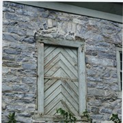
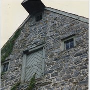
- Photograph- Compass Mill at the intersection of Pierson Road and Rothsville Road (Route 772) just outside of Lititz. Built by the Moravian Congregation c. 1755.
- Object ID
- 1-06-01-14
- Date Range
- c. 2005
1 image
- Object Name
- Print, Photographic
- Collection
- General Collection
- Title
- Photograph- Compass Mill at the intersection of Pierson Road and Rothsville Road (Route 772) just outside of Lititz. Built by the Moravian Congregation c. 1755.
- Description
- Compass Mill at the intersection of Pierson Road and Rothsville Road (Route 772) just outside of Lititz. Built by the Moravian Congregation c. 1755.
- Date Range
- c. 2005
- Storage Location
- LancasterHistory, Lancaster, PA
- Subcategory
- Documentary Artifact
- Search Terms
- Compass Mill
- Lititz
- Mills
- Moravian Congregation
- Pierson Road
- Rothsville Road
- Rothsville, Warwick Twp.
- Warwick Twp.
- Place
- Warwick Twp.
- Object Name
- Print, Photographic
- Condition
- Good
- Object ID
- 1-06-01-14
Images

- Collection
- General Collection
- Title
- Photograph- Detail of Compass Mill at the intersection of Pierson Road and Rothsville Road (Route 772) just outside of Lititz. Built by the Moravian Congregation c. 1755.
- Object ID
- 1-06-01-15
- Date Range
- c. 2005
1 image
- Object Name
- Print, Photographic
- Collection
- General Collection
- Title
- Photograph- Detail of Compass Mill at the intersection of Pierson Road and Rothsville Road (Route 772) just outside of Lititz. Built by the Moravian Congregation c. 1755.
- Description
- Detail of Compass Mill at the intersection of Pierson Road and Rothsville Road (Route 772) just outside of Lititz. Built by the Moravian Congregation c. 1755.
- Date Range
- c. 2005
- Storage Location
- LancasterHistory, Lancaster, PA
- Subcategory
- Documentary Artifact
- Search Terms
- Compass Mill
- Lititz
- Mills
- Moravian Congregation
- Pierson Road
- Rothsville Road
- Rothsville, Warwick Twp.
- Warwick Twp.
- Place
- Warwick Twp.
- Object Name
- Print, Photographic
- Condition
- Good
- Object ID
- 1-06-01-15
Images