It appears no script is enabled within your browser. Please enable JavaScript to use this site.
Skip header and navigation
Toggle navigation
Collections
Search
Help
Privacy
Your Selections:
0
Items
Staff Login
Revise Search
Revise Search
Revise search
Search
Data Source
Library
×
Data Source
All
A
B
C
D
E
F
G
H
I
J
K
L
M
N
O
P
Q
R
S
T
U
V
W
X
Y
Z
Sort
By Count
Alphabetical
Filtered by
Filter
Loading...
Subject
Lancaster County (Pa.) - Maps.
Lancaster (Pa.) - Maps.
6
Pennsylvania - Maps.
3
Cemeteries - Pennsylvania - Lancaster (Lancaster County, Pa. : Township)
2
Conestoga Memorial Park (Lancaster, Pa.) - Maps.
2
Lancaster (Lancaster County, Pa. : Township) - Maps.
2
Maps.
2
Pennsylvania - Lancaster County.
2
Amish Country (Pa.) - Maps, Tourist.
1
Berks County (Pa.) - Maps.
1
Bus travel - Pennsylvania - Lancaster - Maps.
1
Bus travel - Pennsylvania - Lancaster County - Maps.
1
More
×
Subject
All
A
B
C
D
E
F
G
H
I
J
K
L
M
N
O
P
Q
R
S
T
U
V
W
X
Y
Z
Sort
By Count
Alphabetical
Filtered by
Filter
Loading...
Name
Champion Map Corporation.
2
Everts and Stewart.
1
Geological Survey (U.S.)
1
National Survey (Firm)
1
Parton, Ronald J.
1
Pennsylvania Dutch Tourist Bureau.
1
Pennsylvania. Bureau of Topographic and Geologic Survey.
1
Scott, Joshua.
1
×
Name
All
A
B
C
D
E
F
G
H
I
J
K
L
M
N
O
P
Q
R
S
T
U
V
W
X
Y
Z
Sort
By Count
Alphabetical
Filtered by
Filter
Loading...
Decade
1820s
1890s
2
1900s
2
1910s
1
1920s
3
1930s
3
1940s
1
1950s
5
1960s
15
1970s
1980s
7
1990s
5
2000s
5
×
Decade
All
A
B
C
D
E
F
G
H
I
J
K
L
M
N
O
P
Q
R
S
T
U
V
W
X
Y
Z
Sort
By Count
Alphabetical
Filtered by
Filter
Loading...
Material
Cartographic
Text
2
×
Material
All
A
B
C
D
E
F
G
H
I
J
K
L
M
N
O
P
Q
R
S
T
U
V
W
X
Y
Z
Sort
By Count
Alphabetical
Filtered by
Filter
Loading...
Online Media
PDF
1
Website
1
×
Online Media
All
A
B
C
D
E
F
G
H
I
J
K
L
M
N
O
P
Q
R
S
T
U
V
W
X
Y
Z
Sort
By Count
Alphabetical
Filtered by
Filter
Loading...
Advanced Search
Help
All Records
1820s
1970s
Cartographic
Library
Lancaster County (Pa.) - Maps.
Sorted by
Relevance
Sort by Title
Expand All
Collapse All
List View
Gallery View
Print
12 records – page 1 of 2.
Prev
Next
Toggle Full Record
Lancaster County, Pennsylvania
https://collections.lancasterhistory.org/en/permalink/lhdo19840
Corporate Author
Geological Survey (U.S.)
Date of Publication
1978.
Call Number
974.815 L ACO 529 Oversize
More detail
Alternate Title
Lancaster Co., Pa., 1977
Responsibility
mapped, edited, and published by the Geological Survey.
Corporate Author
Geological Survey (U.S.)
Place of Publication
Reston, Va
Publisher
U.S. Geological Survey,
Date of Publication
1978.
Physical Description
1 map : col. ; 110 x 140 cm.
Series
County map series, topographic
Notes
Relief shown by contours and spot heights.
In upper margin: Commonwealth of Pennsylvania, Department of Environmental Resources, Topographic and Geologic Survey.
Includes "Index to 1:24 000 scale maps," "County location," and "Road classification."
Subjects
Lancaster County (Pa.) - Maps.
Pennsylvania - Lancaster County.
Topographic maps.
Maps.
Additional Corporate Author
Pennsylvania. Bureau of Topographic and Geologic Survey.
Location
Lancaster History Library - Map
Call Number
974.815 L ACO 529 Oversize
Less detail
More Like This
Permalink
Toggle Full Record
Champion map of Lancaster, Pennsylvania : including a detailed map of Lancaster County
https://collections.lancasterhistory.org/en/permalink/lhdo15008
Corporate Author
Champion Map Corporation.
Date of Publication
[1974]
Call Number
974.815 LACO 516
More detail
Alternate Title
Lancaster market
Responsibility
Copyright Champion Map Corporation, Ronald J. Parton, chief cartographer. [Prepared for Intelligencer Journal, Lancaster New Era, and Sunday News].
Corporate Author
Champion Map Corporation.
Place of Publication
Charlotte, N.C
Publisher
Champion Map Corporation,
Date of Publication
[1974]
Physical Description
2 maps on 1 sheet : both sides, 2 col., ill. ; 63 x 52 cm. and 52 x 59 cm. on sheet 92 x 61 cm., folded to 24 x 11 cm.
Notes
Folded title: Map of Lancaster City & County, Pennsylvania.
"Map no. GB-010-B."
Shows radial distances.
Indexed.
On verso with index: The Lancaster market.
"Printed: April 1974"--Panel.
Subjects
Lancaster (Pa.) - Maps.
Lancaster County (Pa.) - Maps.
Lancaster Region (Pa.) - Maps.
Additional Author
Parton, Ronald J.
Location
Lancaster History Library - Map
Call Number
974.815 LACO 516
Less detail
More Like This
Permalink
Toggle Full Record
Champion map of Lancaster, Pennsylvania, including a detailed map of Lancaster County
https://collections.lancasterhistory.org/en/permalink/lhdo15373
Corporate Author
Champion Map Corporation.
Date of Publication
[1977]
Call Number
974.815 LACI 522
More detail
Alternate Title
Map of Lancaster, Pennsylvania, city & county
Corporate Author
Champion Map Corporation.
Place of Publication
Charlotte, N.C
Publisher
Champion Map Corp.,
Date of Publication
[1977]
Physical Description
2 maps on 1 sheet : back to back, col. ; 60 x 50 cm. and 48 x 57 cm., folded to 23 x 11 cm.
Notes
City map shows radial distances.
Includes street and location indexes.
On verso: text, location index, location map and ill.
"GG-10-FM."
Scale [ca. 1:31,000] and [ca. 1:200,000].
Subjects
Streets - Pennsylvania - Lancaster - Maps.
Roads - Pennsylvania - Lancaster County - Maps.
Lancaster County (Pa.) - Maps.
Lancaster (Pa.) - Maps.
Location
Lancaster History Library - Map
Call Number
974.815 LACI 522
Less detail
More Like This
Permalink
Toggle Full Record
Map of Lancaster County, Pennsylvania
https://collections.lancasterhistory.org/en/permalink/lhdo15380
Corporate Author
National Survey (Firm)
Date of Publication
c1974.
Call Number
974.815 LACO 515
More detail
Corporate Author
National Survey (Firm)
Place of Publication
Chester, Vt
Publisher
The National Survey,
Date of Publication
c1974.
Physical Description
2 maps on 1 sheet : both sides, 2 col. ; 67 x 90 cm. or smaller, folded to 23 x 11 cm.
Notes
Panel title.
Oriented with north toward the upper left.
Includes indexes to points of interest and information centers, advertisements, and list of advertisers.
Advertisements, list of advertisers, and map of Lancaster, Pa. on verso.
Subjects
Lancaster County (Pa.) - Maps.
Lancaster (Pa.) - Maps.
Location
Lancaster History Library - Map
Call Number
974.815 LACO 515
Less detail
More Like This
Permalink
Toggle Full Record
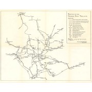
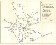
Routes of the Garden Spot Trolleys map
https://collections.lancasterhistory.org/en/permalink/lhdo5479
Date of Publication
1977.
Call Number
974.815 SEPA 102
More detail
1 document
Responsibility
Drawn by B. W. Rohrbeck.
Place of Publication
[s.l.]
Publisher
[s.n.] ,
Date of Publication
1977.
Physical Description
1 map ; 36 x 46 cm.
Notes
Includes route names.
Subjects
Street-railroads - Pennsylvania - Lancaster County
Transportation - Pennsylvania - Lancaster County
Lancaster County (Pa.) - Maps.
Location
Lancaster History Library - Map
Call Number
974.815 SEPA 102
Documents
map_974.815_SEPA_102_.pdf
Read PDF
Download PDF
Less detail
More Like This
Permalink
Toggle Full Record
Lancaster County : 1970 census tracts
https://collections.lancasterhistory.org/en/permalink/lhdo5750
Date of Publication
December 1972..
Call Number
974.815 LACO 502 Oversize
More detail
Responsibility
prepared for the Lancaster County Planning Commission.
Place of Publication
Norristown, Pa
Publisher
Vernon Graphics, Inc. ,
Date of Publication
December 1972..
Physical Description
1 map ; 100 x 110 cm.
Notes
Blue line print.
Includes index.
Subjects
Census districts - Pennsylvania - Lancaster County
Lancaster County (Pa.) - Maps.
Location
Lancaster History Library - Map
Call Number
974.815 LACO 502 Oversize
Less detail
More Like This
Permalink
Toggle Full Record
Lancaster County Pennsylvania
https://collections.lancasterhistory.org/en/permalink/lhdo5751
Date of Publication
1971.
Call Number
974.815 LACO 503 Oversize
More detail
Responsibility
prepared for the Lancaster Count Planning Commission.
Place of Publication
Norristown, Pa
Publisher
Vernon Graphics ,
Date of Publication
1971.
Physical Description
1 map ; 99 x 109 cm.
Subjects
Lancaster County (Pa.) - Maps.
Location
Lancaster History Library - Map
Call Number
974.815 LACO 503 Oversize
Less detail
More Like This
Permalink
Toggle Full Record
Map of Lancaster County, Pennsylvania
https://collections.lancasterhistory.org/en/permalink/lhdo19526
Author
Scott, Joshua.
Date of Publication
1824.
Call Number
912.74815 L244 1824
More detail
1 website
Responsibility
respectfully dedicated to the inhabitants by Joshua Scott.
Author
Scott, Joshua.
Place of Publication
Lancaster
Publisher
[s.n.],
Date of Publication
1824.
Physical Description
1 map : hand col., cloth backing ; 87 x 115 cm., folded to 93 x 61 cm.
Notes
General-content county map also showing election districts.
Hand col. to emphasize township boundaries and territories.
Relief shown by hachures.
Orientated with north toward the upper left.
Prime meridian: Washington (D.C.).
Published "Lancaster January 1st 1824".
Originally printed on 4 sheets (later conjoined).
Copy 2: From the collections of the Heritage Center, P05.29.1.
LC Land ownership maps,
Copy 2: green boards.
Copy 1: Marble boards, three-quarater red leather, spine taped.
Subjects
Election districts - Pennsylvania - Lancaster County - Maps.
Landowners - Pennsylvania - Lancaster County - Maps.
Election districts.
Landowners.
Lancaster County (Pa.) - Maps.
Pennsylvania - Lancaster County.
Maps.
Location
Lancaster History Library - Rare Books
Call Number
912.74815 L244 1824
Websites
http://hdl.loc.gov/loc.gmd/g3823l.la000760
Less detail
More Like This
Permalink
Toggle Full Record
[Map of Mount Joy, Pa. area]
https://collections.lancasterhistory.org/en/permalink/lhdo1860
Date of Publication
1971
Call Number
974.815 MJOT 100
More detail
Responsibility
Lancaster County Planning Commission.
Place of Publication
[Lancaster, Pa.]
Publisher
Lancaster County Planning Commission ,
Date of Publication
1971
Physical Description
1 map ; 56 x 86 cm
Notes
Includes portions of East Donegal, Mount Joy and Rapho townships.
Subjects
Land use - Pennsylvania - Lancaster County
Lancaster County (Pa.) - Maps.
Location
Lancaster History Library - Map
Call Number
974.815 MJOT 100
Less detail
More Like This
Permalink
Toggle Full Record
Map of Lancaster County Pennsylvania
https://collections.lancasterhistory.org/en/permalink/lhdo5161
Date of Publication
1821.
Call Number
974.815 LACO 110
More detail
Place of Publication
York, Pa
Publisher
William Wagner ,
Date of Publication
1821.
Physical Description
1 map : photocopy ; 41 x 55 cm.
Notes
Relief shown by hachures.
"Entered according to Act of Congress August 27, 1821 by W. Wagner of the State of Penna".
Shows locations of mills, furnaces, churches, township lines, turnpikes and roads.
Subjects
Lancaster County (Pa.) - Maps.
Location
Lancaster History Library - Map
Call Number
974.815 LACO 110
Less detail
More Like This
Permalink
12 records – page 1 of 2.
Prev
Next