It appears no script is enabled within your browser. Please enable JavaScript to use this site.
Skip header and navigation
Toggle navigation
Collections
Search
Help
Privacy
Your Selections:
0
Items
Staff Login
Revise Search
Revise Search
Revise search
Search
Data Source
Photographs
7648
Library
2
×
Data Source
All
A
B
C
D
E
F
G
H
I
J
K
L
M
N
O
P
Q
R
S
T
U
V
W
X
Y
Z
Sort
By Count
Alphabetical
Filtered by
Filter
Loading...
Collection
Darmstaetter Collection
6814
Dillman Bomberger Collection
522
General Collection
259
DeWalt Products Collection
26
Lancaster Recreation Commission Photograph Collection
13
Paul L. Schlotzhauer Photograph Collection
4
American Lung Association Photograph Collection
3
Abele and Shirk Family Photograph Collection
1
Bowman Technical School Photograph Collection
1
Johnny Hauck Photograph Collection
1
Mary Brecht Pulver Photograph Collection
1
Postcard Collection
1
More
×
Collection
All
A
B
C
D
E
F
G
H
I
J
K
L
M
N
O
P
Q
R
S
T
U
V
W
X
Y
Z
Sort
By Count
Alphabetical
Filtered by
Filter
Loading...
Subject
Documentary Artifact
7578
Dwellings
358
Military
267
World War I
263
Houses
221
Uniforms
203
Soldiers
199
Students
197
Franklin and Marshall College
194
Schools
179
Portraits
176
Automobiles
174
More
×
Subject
All
A
B
C
D
E
F
G
H
I
J
K
L
M
N
O
P
Q
R
S
T
U
V
W
X
Y
Z
Sort
By Count
Alphabetical
Filtered by
Filter
Loading...
Name
Register of Wills
8784
Darmstaetter's
County Commissioners
5861
Pennsylvania. Court of Common Pleas (Lancaster County)
2250
Buchanan, James
1760
Smith, Richard Flanders
1413
Clerk of Courts of Lancaster County
1099
Johnston, Harriet Lane
926
Landis, David Bachman
897
Yeates, Jasper,
754
Orphans' Court
676
Schopf, Edward
603
More
×
Name
All
A
B
C
D
E
F
G
H
I
J
K
L
M
N
O
P
Q
R
S
T
U
V
W
X
Y
Z
Sort
By Count
Alphabetical
Filtered by
Filter
Loading...
Place
Lancaster
2488
Manheim Twp.
155
Millersville
110
Lancaster Twp.
99
Manheim
68
Quarryville
62
Lititz
57
Columbia
51
East Lampeter Twp.
43
Woodstock, Shenandoah County, Virginia
37
East Hempfield Twp.
35
Mount Joy
35
More
×
Place
All
A
B
C
D
E
F
G
H
I
J
K
L
M
N
O
P
Q
R
S
T
U
V
W
X
Y
Z
Sort
By Count
Alphabetical
Filtered by
Filter
Loading...
Decade
1020s
1
1190s
4
1720s
1
1820s
2
1890s
1
1900s
556
1910s
805
1920s
3143
1930s
1519
1940s
34
1950s
3
×
Decade
All
A
B
C
D
E
F
G
H
I
J
K
L
M
N
O
P
Q
R
S
T
U
V
W
X
Y
Z
Sort
By Count
Alphabetical
Filtered by
Filter
Loading...
Material
Print, Photographic
5551
Negative
1435
Negative, Glass Plate
655
Negative, Sheet Film
3
Text
2
Transparency, Slide
2
Postcard
1
Print
1
×
Material
All
A
B
C
D
E
F
G
H
I
J
K
L
M
N
O
P
Q
R
S
T
U
V
W
X
Y
Z
Sort
By Count
Alphabetical
Filtered by
Filter
Loading...
Online Media
Image
7640
×
Online Media
All
A
B
C
D
E
F
G
H
I
J
K
L
M
N
O
P
Q
R
S
T
U
V
W
X
Y
Z
Sort
By Count
Alphabetical
Filtered by
Filter
Loading...
Advanced Search
Help
All Records
Lehigh County (Pa.). Board of County Commissioners.
Berks County (Pa.). Board of County Commissioners.
Bomberger, Dillman Randolph
Darmstaetter's
Sorted by
Title
Sort by Relevance
Expand All
Collapse All
List View
Gallery View
Print
7650 records – page 1 of 765.
Prev
Next
Toggle Full Record
Berks County : a governmental picture and a brief historic review
https://collections.lancasterhistory.org/en/permalink/lhdo6025
Corporate Author
Berks County (Pa.). Board of County Commissioners.
Edition
1st ed.
Date of Publication
c1959.
Call Number
974.816 B513
More detail
Corporate Author
Berks County (Pa.). Board of County Commissioners.
Edition
1st ed.
Place of Publication
Reading, Pa
Date of Publication
c1959.
Physical Description
120 p. : illus., ports., col. maps ; 23 cm.
Notes
Bibliography: p. 2.
Subjects
Berks County (Pa.) - Politics and government.
Location
Lancaster History Library - Book
Call Number
974.816 B513
Less detail
More Like This
Permalink
Toggle Full Record
Inventory of the county archives of Pennsylvania: Lehigh County
https://collections.lancasterhistory.org/en/permalink/lhdo7198
Corporate Author
Lehigh County (Pa.). Board of County Commissioners.
Date of Publication
1946.
Call Number
974.827 P415
More detail
Corporate Author
Lehigh County (Pa.). Board of County Commissioners.
Place of Publication
Allentown, Pa
Publisher
The Board of County Commissioners,
Date of Publication
1946.
Physical Description
1 p. β., v-ix, 262 p. illus. (maps) 23 cm.
Notes
Prepared with the cooperation of the Pennsylvania Historical Records Survey.
Bibliography: p. 244-248.
Subjects
Archives - Pennsylvania - Lehigh County.
Additional Corporate Author
Historical Records Survey of Pennsylvania.
Location
Lancaster History Library - Book
Call Number
974.827 P415
Less detail
More Like This
Permalink
Toggle Full Record
Negative
https://collections.lancasterhistory.org/en/permalink/c646568d-8c52-406a-ba0e-558305303232
Collection
Darmstaetter Collection
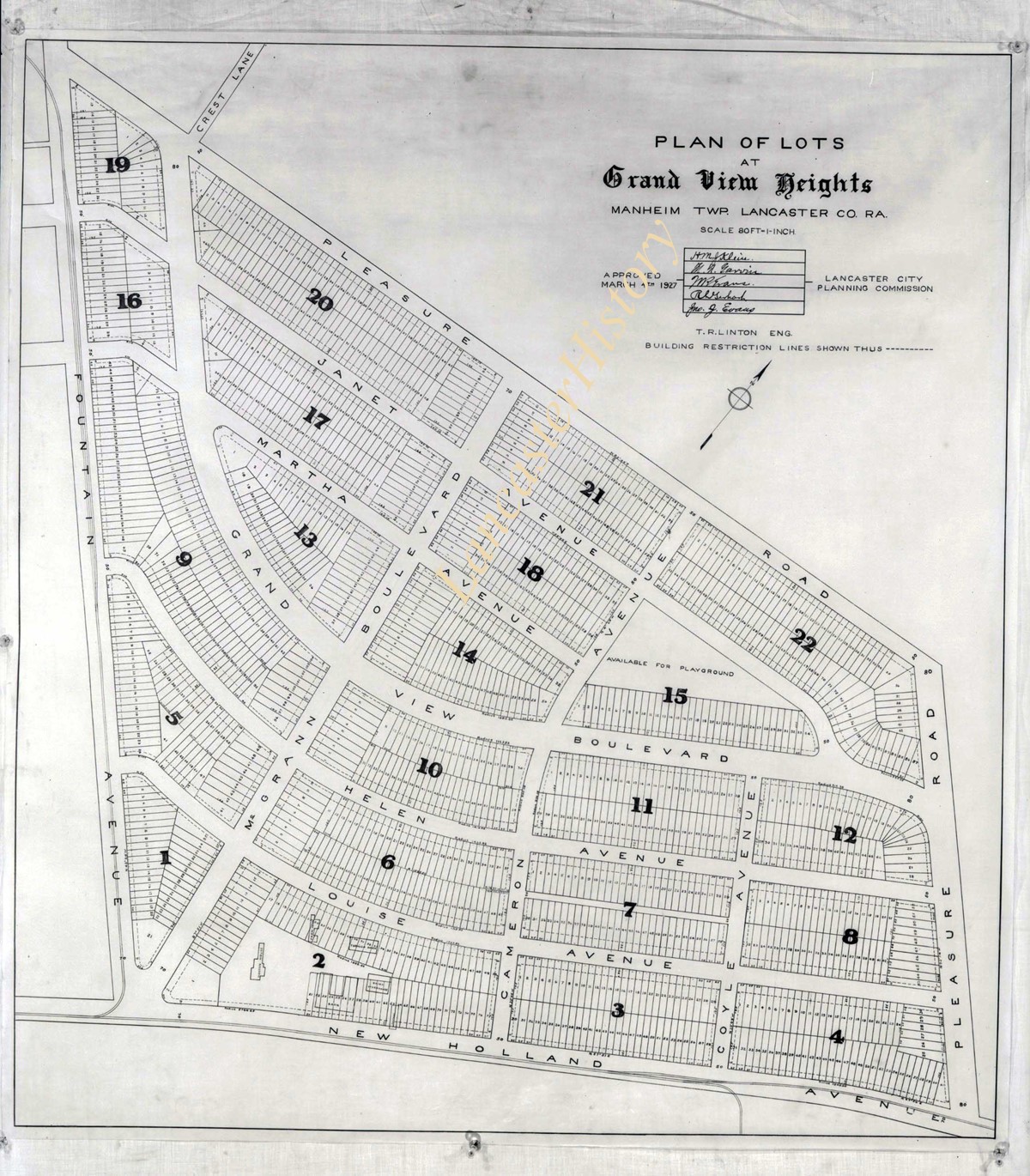
Title
Photograph- Plan for lots in Grandview Heights.
Object ID
D-07-03-56
More detail
1 image
Object Name
Negative
Collection
Darmstaetter Collection
Title
Photograph- Plan for lots in Grandview Heights.
Description
Plan for lots in Grandview Heights. 1 print only
Storage Location
LancasterHistory, Lancaster, PA
Studio
Darmstaetter's
Subcategory
Documentary Artifact
Classification
Maps
Place
Manheim Twp.
Object Name
Negative
Film Size
8 x 10 inches
Object ID
D-07-03-56
Negative Number
yes
Other Number
660-870
Images
Less detail
More Like This
Permalink
Toggle Full Record
Negative
https://collections.lancasterhistory.org/en/permalink/7723bebb-3aa3-432f-abec-170944938900
Collection
Darmstaetter Collection
Title
Photograph- Plan for Greater Lancaster showing Wheatland Hills.
Object ID
D-07-03-55
Date Range
January 24, 1927
More detail
1 image
Object Name
Negative
Collection
Darmstaetter Collection
Title
Photograph- Plan for Greater Lancaster showing Wheatland Hills.
Description
Plan for Greater Lancaster showing Wheatland Hills. 1 print only
Date Range
January 24, 1927
Storage Location
LancasterHistory, Lancaster, PA
Studio
Darmstaetter's
Subcategory
Documentary Artifact
Classification
Maps
Place
East Hempfield Twp.
Object Name
Negative
Film Size
10 x 8 inches
Object ID
D-07-03-55
Negative Number
yes
Other Number
660-257
Images
Less detail
More Like This
Permalink
Toggle Full Record
Negative
https://collections.lancasterhistory.org/en/permalink/7b4479be-5ce0-4aed-b9d1-296882065808
Collection
Darmstaetter Collection
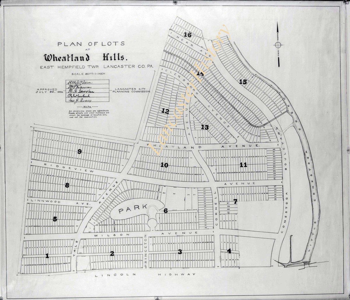
Title
Photograph- Plan of lots at Wheatland Hills.
Object ID
D-07-03-54
More detail
1 image
Object Name
Negative
Collection
Darmstaetter Collection
Title
Photograph- Plan of lots at Wheatland Hills.
Description
Plan of lots at Wheatland Hills. 1 print only
Storage Location
LancasterHistory, Lancaster, PA
Studio
Darmstaetter's
Subcategory
Documentary Artifact
Classification
Maps
Place
East Hempfield Twp.
Object Name
Negative
Film Size
10 x 8 inches
Object ID
D-07-03-54
Negative Number
yes
Other Number
660-180
Images
Less detail
More Like This
Permalink
Toggle Full Record
Negative
https://collections.lancasterhistory.org/en/permalink/cfeaaee4-cdc4-4b21-aef9-829150874936
Collection
Darmstaetter Collection
Title
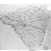
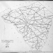
Photograph- Map of Lancaster County.
Object ID
D-07-03-53
Date Range
1926/02/22
More detail
1 image
Object Name
Negative
Collection
Darmstaetter Collection
Title
Photograph- Map of Lancaster County.
Description
Map of Lancaster County. 1 print only
Date Range
1926/02/22
Year Range From
1926
Storage Location
LancasterHistory, Lancaster, PA
Studio
Darmstaetter's
Subcategory
Documentary Artifact
Classification
Maps
Place
Lancaster County
Object Name
Negative
Film Size
10 x 8 inches
Object ID
D-07-03-53
Negative Number
yes
Other Number
642-435
Images
Less detail
More Like This
Permalink
Toggle Full Record
Negative
https://collections.lancasterhistory.org/en/permalink/23988159-db5d-4ca5-b01e-153188656558
Collection
Darmstaetter Collection
Title
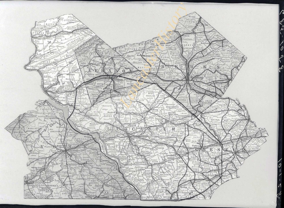
Photograph- Map showing Berks, Lebanon, York, Chester, and Lancaster Counties.
Object ID
D-07-03-52
Date Range
1928/10/01
More detail
1 image
Object Name
Negative
Collection
Darmstaetter Collection
Title
Photograph- Map showing Berks, Lebanon, York, Chester, and Lancaster Counties.
Description
Map showing Berks, Lebanon, York, Chester, and Lancaster Counties. 1 print only
Date Range
1928/10/01
Year Range From
1928
Storage Location
LancasterHistory, Lancaster, PA
Studio
Darmstaetter's
Subcategory
Documentary Artifact
Classification
Maps
Object Name
Negative
Film Size
6.5 x 5 inches
Object ID
D-07-03-52
Negative Number
yes
Other Number
685-1058
Images
Less detail
More Like This
Permalink
Toggle Full Record
Negative
https://collections.lancasterhistory.org/en/permalink/7bf4d352-83bc-411e-b713-389752566549
Collection
Darmstaetter Collection
Title
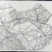
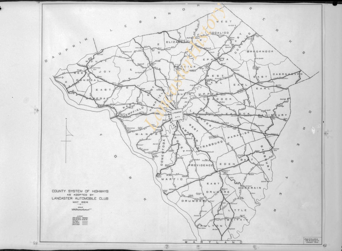
Photograph- Map showing county system of highways as adopted by the Lancaster Automobile Club, May 1924.
Object ID
D-07-03-51
Date Range
1924/05/19
More detail
1 image
Object Name
Negative
Collection
Darmstaetter Collection
Title
Photograph- Map showing county system of highways as adopted by the Lancaster Automobile Club, May 1924.
Description
Map showing county system of highways as adopted by the Lancaster Automobile Club, May 1924. 1 print only
Date Range
1924/05/19
Year Range From
1924
Storage Location
LancasterHistory, Lancaster, PA
Studio
Darmstaetter's
Subcategory
Documentary Artifact
Classification
Maps
Place
Lancaster County
Object Name
Negative
Film Size
6.5 x 5 inches
Object ID
D-07-03-51
Negative Number
yes
Other Number
613-1493
Images
Less detail
More Like This
Permalink
Toggle Full Record
Negative
https://collections.lancasterhistory.org/en/permalink/970653d0-e548-4cad-a0d2-755934254994
Collection
Darmstaetter Collection
Title
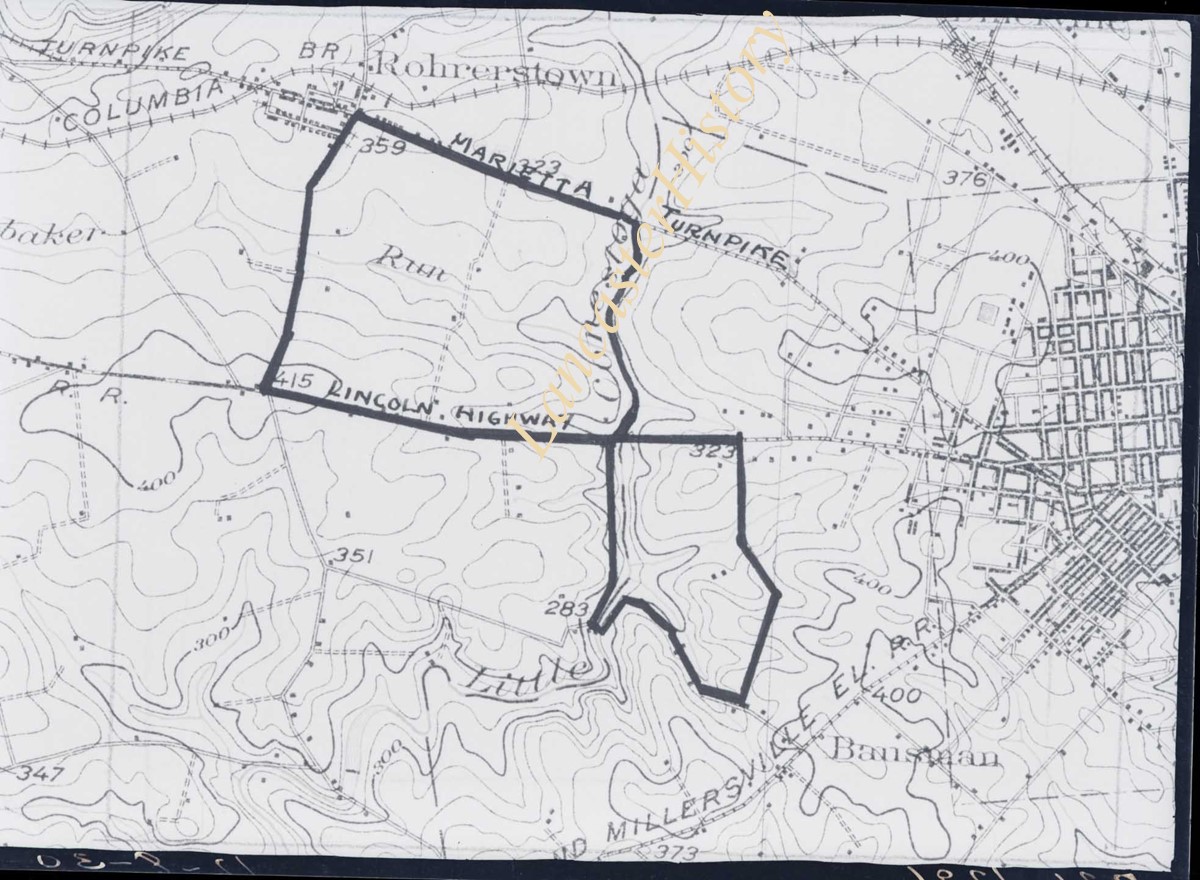
Photograph- Map showing topography and Lincoln Highway and Marietta Turnpike.
Object ID
D-07-03-50
Date Range
1930/17/09
More detail
1 image
Object Name
Negative
Collection
Darmstaetter Collection
Title
Photograph- Map showing topography and Lincoln Highway and Marietta Turnpike.
Description
Map showing topography and Lincoln Highway and Marietta Turnpike. 1 print only
Date Range
1930/17/09
Year Range From
1930
Storage Location
LancasterHistory, Lancaster, PA
Studio
Darmstaetter's
Subcategory
Documentary Artifact
Classification
Maps
Place
Lancaster County
Object Name
Negative
Film Size
6.5 x 5 inches
Object ID
D-07-03-50
Negative Number
yes
Other Number
721-1796
Images
Less detail
More Like This
Permalink
Toggle Full Record
Negative
https://collections.lancasterhistory.org/en/permalink/5f58e4ef-9540-4971-874d-011722330483
Collection
Darmstaetter Collection
Title
Photograph- Map showing Martic, Fulton, and Drumore Townships.
Object ID
D-07-03-49
Date Range
1927/08/29
More detail
1 image
Object Name
Negative
Collection
Darmstaetter Collection
Title
Photograph- Map showing Martic, Fulton, and Drumore Townships.
Description
Map showing Martic, Fulton, and Drumore Townships. 1 print only
Date Range
1927/08/29
Year Range From
1927
Storage Location
LancasterHistory, Lancaster, PA
Studio
Darmstaetter's
Subcategory
Documentary Artifact
Classification
Maps
Object Name
Negative
Film Size
10 x 8 inches
Object ID
D-07-03-49
Negative Number
yes
Other Number
670-910
Images
Less detail
More Like This
Permalink
7650 records – page 1 of 765.
Prev
Next