Skip header and navigation

Revise Search

7067 records – page 1 of 707.

Collection
Collateral Appraisements
Title
Collateral Appraisements
Object ID
Coll App 1892 F001 R
Date Range
1892
Collection
Collateral Appraisements
Title
Collateral Appraisements
Description
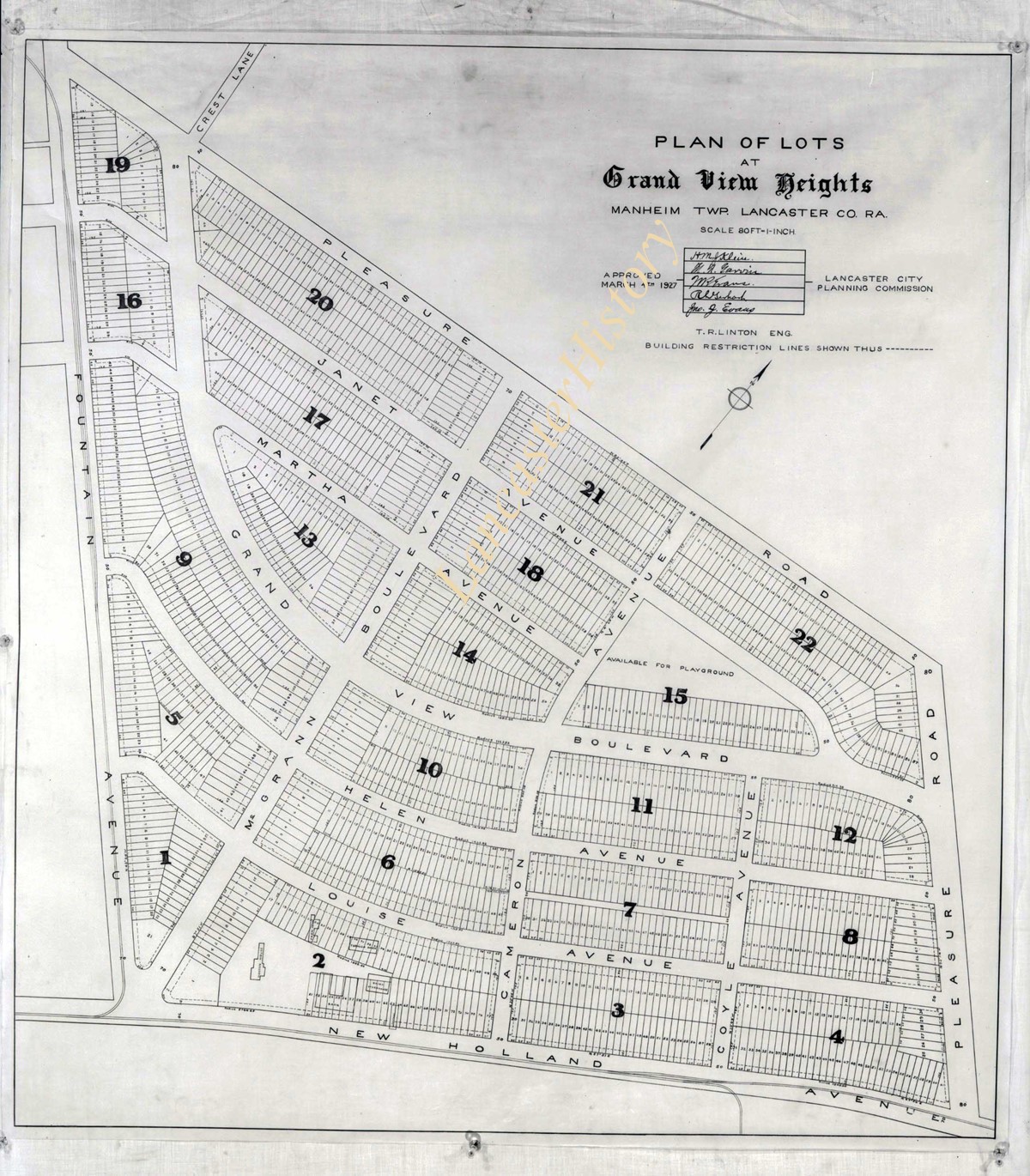
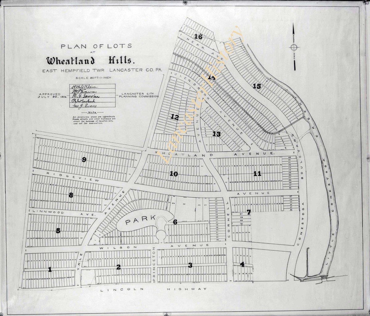
Appraisements of real estate for inheritance tax. Some personal property appraisals are also included. Appraisals include: name of decedent; location and description of real estate; description of personal property; valuation of real estate and personal property; and assessed tax. May also include names of heirs. Arranged chronologically by year, then alphabetically by first letter of decedent's last name. Handwritten; from 1886, handwritten on printed forms.
System of Arrangement
Arranged chronologically by year, then alphabetically by first letter of decedent's last name.
Date Range
1892
Date of Accumulation
1849-1913
Year
1892
Creator
Register of Wills
Storage Location
LancasterHistory, Lancaster, PA
Storage Room
Archives West
Storage Container
Box 0012
People
Ream, Tobias
Subcategory
Documentary Artifact
Search Terms
Collateral appraisement
Reamstown, East Cocalico Twp.
Place
Reamstown, East Cocalico Twp.
Extent
16 boxes (8 cubic feet)
Object Name
Appraisal
Language
English
Condition
Fair
Object ID
Coll App 1892 F001 R
Box Number
012
Additional Notes
1 item, 1 piece
Access Conditions / Restrictions
Request at research desk. Photocopy made by staff member.
Classification
RG 03-00 0312
Description Level
Item
Less detail
Collection
Darmstaetter Collection
Title
Photograph- Plan for lots in Grandview Heights.
Object ID
D-07-03-56
  1 image  
Object Name
Negative
Collection
Darmstaetter Collection
Title
Photograph- Plan for lots in Grandview Heights.
Description
Plan for lots in Grandview Heights. 1 print only
Storage Location
LancasterHistory, Lancaster, PA
Studio
Darmstaetter's
Subcategory
Documentary Artifact
Classification
Maps
Place
Manheim Twp.
Object Name
Negative
Film Size
8 x 10 inches
Object ID
D-07-03-56
Negative Number
yes
Other Number
660-870
Images
Less detail
Collection
Darmstaetter Collection
Title
Photograph- Plan for Greater Lancaster showing Wheatland Hills.
Object ID
D-07-03-55
Date Range
January 24, 1927
  1 image  
Object Name
Negative
Collection
Darmstaetter Collection
Title
Photograph- Plan for Greater Lancaster showing Wheatland Hills.
Description
Plan for Greater Lancaster showing Wheatland Hills. 1 print only
Date Range
January 24, 1927
Storage Location
LancasterHistory, Lancaster, PA
Studio
Darmstaetter's
Subcategory
Documentary Artifact
Classification
Maps
Place
East Hempfield Twp.
Object Name
Negative
Film Size
10 x 8 inches
Object ID
D-07-03-55
Negative Number
yes
Other Number
660-257
Images
Less detail
Collection
Darmstaetter Collection
Title
Photograph- Plan of lots at Wheatland Hills.
Object ID
D-07-03-54
  1 image  
Object Name
Negative
Collection
Darmstaetter Collection
Title
Photograph- Plan of lots at Wheatland Hills.
Description
Plan of lots at Wheatland Hills. 1 print only
Storage Location
LancasterHistory, Lancaster, PA
Studio
Darmstaetter's
Subcategory
Documentary Artifact
Classification
Maps
Place
East Hempfield Twp.
Object Name
Negative
Film Size
10 x 8 inches
Object ID
D-07-03-54
Negative Number
yes
Other Number
660-180
Images
Less detail
Collection
Darmstaetter Collection
Title
Photograph- Map of Lancaster County.
Object ID
D-07-03-53
Date Range
1926/02/22
  1 image  
Object Name
Negative
Collection
Darmstaetter Collection
Title
Photograph- Map of Lancaster County.
Description
Map of Lancaster County. 1 print only
Date Range
1926/02/22
Year Range From
1926
Storage Location
LancasterHistory, Lancaster, PA
Studio
Darmstaetter's
Subcategory
Documentary Artifact
Classification
Maps
Place
Lancaster County
Object Name
Negative
Film Size
10 x 8 inches
Object ID
D-07-03-53
Negative Number
yes
Other Number
642-435
Images
Less detail
Collection
Darmstaetter Collection
Title
Photograph- Map showing Berks, Lebanon, York, Chester, and Lancaster Counties.
Object ID
D-07-03-52
Date Range
1928/10/01
  1 image  
Object Name
Negative
Collection
Darmstaetter Collection
Title
Photograph- Map showing Berks, Lebanon, York, Chester, and Lancaster Counties.
Description
Map showing Berks, Lebanon, York, Chester, and Lancaster Counties. 1 print only
Date Range
1928/10/01
Year Range From
1928
Storage Location
LancasterHistory, Lancaster, PA
Studio
Darmstaetter's
Subcategory
Documentary Artifact
Classification
Maps
Object Name
Negative
Film Size
6.5 x 5 inches
Object ID
D-07-03-52
Negative Number
yes
Other Number
685-1058
Images
Less detail
Collection
Darmstaetter Collection
Title
Photograph- Map showing county system of highways as adopted by the Lancaster Automobile Club, May 1924.
Object ID
D-07-03-51
Date Range
1924/05/19
  1 image  
Object Name
Negative
Collection
Darmstaetter Collection
Title
Photograph- Map showing county system of highways as adopted by the Lancaster Automobile Club, May 1924.
Description
Map showing county system of highways as adopted by the Lancaster Automobile Club, May 1924. 1 print only
Date Range
1924/05/19
Year Range From
1924
Storage Location
LancasterHistory, Lancaster, PA
Studio
Darmstaetter's
Subcategory
Documentary Artifact
Classification
Maps
Place
Lancaster County
Object Name
Negative
Film Size
6.5 x 5 inches
Object ID
D-07-03-51
Negative Number
yes
Other Number
613-1493
Images
Less detail
Collection
Darmstaetter Collection
Title
Photograph- Map showing topography and Lincoln Highway and Marietta Turnpike.
Object ID
D-07-03-50
Date Range
1930/17/09
  1 image  
Object Name
Negative
Collection
Darmstaetter Collection
Title
Photograph- Map showing topography and Lincoln Highway and Marietta Turnpike.
Description
Map showing topography and Lincoln Highway and Marietta Turnpike. 1 print only
Date Range
1930/17/09
Year Range From
1930
Storage Location
LancasterHistory, Lancaster, PA
Studio
Darmstaetter's
Subcategory
Documentary Artifact
Classification
Maps
Place
Lancaster County
Object Name
Negative
Film Size
6.5 x 5 inches
Object ID
D-07-03-50
Negative Number
yes
Other Number
721-1796
Images
Less detail
Collection
Darmstaetter Collection
Title
Photograph- Map showing Martic, Fulton, and Drumore Townships.
Object ID
D-07-03-49
Date Range
1927/08/29
  1 image  
Object Name
Negative
Collection
Darmstaetter Collection
Title
Photograph- Map showing Martic, Fulton, and Drumore Townships.
Description
Map showing Martic, Fulton, and Drumore Townships. 1 print only
Date Range
1927/08/29
Year Range From
1927
Storage Location
LancasterHistory, Lancaster, PA
Studio
Darmstaetter's
Subcategory
Documentary Artifact
Classification
Maps
Object Name
Negative
Film Size
10 x 8 inches
Object ID
D-07-03-49
Negative Number
yes
Other Number
670-910
Images
Less detail
Collection
Darmstaetter Collection
Title
Photograph- Map showing Fulton and Drumore Townships.
Object ID
D-07-03-48
Date Range
1924/07/21
  1 image  
Object Name
Negative
Collection
Darmstaetter Collection
Title
Photograph- Map showing Fulton and Drumore Townships.
Description
Map showing Fulton and Drumore Townships. 1 print only
Date Range
1924/07/21
Year Range From
1924
Storage Location
LancasterHistory, Lancaster, PA
Studio
Darmstaetter's
Subcategory
Documentary Artifact
Classification
Maps
Object Name
Negative
Film Size
11 x 7 inches
Object ID
D-07-03-48
Negative Number
yes
Other Number
614-1666
Images
Less detail

7067 records – page 1 of 707.