Skip header and navigation

Revise Search

20 records – page 1 of 1.

Collection
Darmstaetter Collection
Title
Photograph- Plan for lots in Grandview Heights.
Object ID
D-07-03-56
  1 image  
Object Name
Negative
Collection
Darmstaetter Collection
Title
Photograph- Plan for lots in Grandview Heights.
Description
Plan for lots in Grandview Heights. 1 print only
Storage Location
LancasterHistory, Lancaster, PA
Studio
Darmstaetter's
Subcategory
Documentary Artifact
Classification
Maps
Place
Manheim Twp.
Object Name
Negative
Film Size
8 x 10 inches
Object ID
D-07-03-56
Negative Number
yes
Other Number
660-870
Images
Less detail
Collection
Darmstaetter Collection
Title
Photograph- Plan for Greater Lancaster showing Wheatland Hills.
Object ID
D-07-03-55
Date Range
January 24, 1927
  1 image  
Object Name
Negative
Collection
Darmstaetter Collection
Title
Photograph- Plan for Greater Lancaster showing Wheatland Hills.
Description
Plan for Greater Lancaster showing Wheatland Hills. 1 print only
Date Range
January 24, 1927
Storage Location
LancasterHistory, Lancaster, PA
Studio
Darmstaetter's
Subcategory
Documentary Artifact
Classification
Maps
Place
East Hempfield Twp.
Object Name
Negative
Film Size
10 x 8 inches
Object ID
D-07-03-55
Negative Number
yes
Other Number
660-257
Images
Less detail
Collection
Darmstaetter Collection
Title
Photograph- Plan of lots at Wheatland Hills.
Object ID
D-07-03-54
  1 image  
Object Name
Negative
Collection
Darmstaetter Collection
Title
Photograph- Plan of lots at Wheatland Hills.
Description
Plan of lots at Wheatland Hills. 1 print only
Storage Location
LancasterHistory, Lancaster, PA
Studio
Darmstaetter's
Subcategory
Documentary Artifact
Classification
Maps
Place
East Hempfield Twp.
Object Name
Negative
Film Size
10 x 8 inches
Object ID
D-07-03-54
Negative Number
yes
Other Number
660-180
Images
Less detail
Collection
Darmstaetter Collection
Title
Photograph- Map of Lancaster County.
Object ID
D-07-03-53
Date Range
1926/02/22
  1 image  
Object Name
Negative
Collection
Darmstaetter Collection
Title
Photograph- Map of Lancaster County.
Description
Map of Lancaster County. 1 print only
Date Range
1926/02/22
Year Range From
1926
Storage Location
LancasterHistory, Lancaster, PA
Studio
Darmstaetter's
Subcategory
Documentary Artifact
Classification
Maps
Place
Lancaster County
Object Name
Negative
Film Size
10 x 8 inches
Object ID
D-07-03-53
Negative Number
yes
Other Number
642-435
Images
Less detail
Collection
Darmstaetter Collection
Title
Photograph- Map showing Berks, Lebanon, York, Chester, and Lancaster Counties.
Object ID
D-07-03-52
Date Range
1928/10/01
  1 image  
Object Name
Negative
Collection
Darmstaetter Collection
Title
Photograph- Map showing Berks, Lebanon, York, Chester, and Lancaster Counties.
Description
Map showing Berks, Lebanon, York, Chester, and Lancaster Counties. 1 print only
Date Range
1928/10/01
Year Range From
1928
Storage Location
LancasterHistory, Lancaster, PA
Studio
Darmstaetter's
Subcategory
Documentary Artifact
Classification
Maps
Object Name
Negative
Film Size
6.5 x 5 inches
Object ID
D-07-03-52
Negative Number
yes
Other Number
685-1058
Images
Less detail
Collection
Darmstaetter Collection
Title
Photograph- Map showing county system of highways as adopted by the Lancaster Automobile Club, May 1924.
Object ID
D-07-03-51
Date Range
1924/05/19
  1 image  
Object Name
Negative
Collection
Darmstaetter Collection
Title
Photograph- Map showing county system of highways as adopted by the Lancaster Automobile Club, May 1924.
Description
Map showing county system of highways as adopted by the Lancaster Automobile Club, May 1924. 1 print only
Date Range
1924/05/19
Year Range From
1924
Storage Location
LancasterHistory, Lancaster, PA
Studio
Darmstaetter's
Subcategory
Documentary Artifact
Classification
Maps
Place
Lancaster County
Object Name
Negative
Film Size
6.5 x 5 inches
Object ID
D-07-03-51
Negative Number
yes
Other Number
613-1493
Images
Less detail
Collection
Darmstaetter Collection
Title
Photograph- Map showing topography and Lincoln Highway and Marietta Turnpike.
Object ID
D-07-03-50
Date Range
1930/17/09
  1 image  
Object Name
Negative
Collection
Darmstaetter Collection
Title
Photograph- Map showing topography and Lincoln Highway and Marietta Turnpike.
Description
Map showing topography and Lincoln Highway and Marietta Turnpike. 1 print only
Date Range
1930/17/09
Year Range From
1930
Storage Location
LancasterHistory, Lancaster, PA
Studio
Darmstaetter's
Subcategory
Documentary Artifact
Classification
Maps
Place
Lancaster County
Object Name
Negative
Film Size
6.5 x 5 inches
Object ID
D-07-03-50
Negative Number
yes
Other Number
721-1796
Images
Less detail
Collection
Darmstaetter Collection
Title
Photograph- Map showing Martic, Fulton, and Drumore Townships.
Object ID
D-07-03-49
Date Range
1927/08/29
  1 image  
Object Name
Negative
Collection
Darmstaetter Collection
Title
Photograph- Map showing Martic, Fulton, and Drumore Townships.
Description
Map showing Martic, Fulton, and Drumore Townships. 1 print only
Date Range
1927/08/29
Year Range From
1927
Storage Location
LancasterHistory, Lancaster, PA
Studio
Darmstaetter's
Subcategory
Documentary Artifact
Classification
Maps
Object Name
Negative
Film Size
10 x 8 inches
Object ID
D-07-03-49
Negative Number
yes
Other Number
670-910
Images
Less detail
Collection
Darmstaetter Collection
Title
Photograph- Map showing Fulton and Drumore Townships.
Object ID
D-07-03-48
Date Range
1924/07/21
  1 image  
Object Name
Negative
Collection
Darmstaetter Collection
Title
Photograph- Map showing Fulton and Drumore Townships.
Description
Map showing Fulton and Drumore Townships. 1 print only
Date Range
1924/07/21
Year Range From
1924
Storage Location
LancasterHistory, Lancaster, PA
Studio
Darmstaetter's
Subcategory
Documentary Artifact
Classification
Maps
Object Name
Negative
Film Size
11 x 7 inches
Object ID
D-07-03-48
Negative Number
yes
Other Number
614-1666
Images
Less detail
Collection
Darmstaetter Collection
Title
Photograph- Map--Topography of the State of Pennsylvania.
Object ID
D-07-03-46
  1 image  
Object Name
Negative
Collection
Darmstaetter Collection
Title
Photograph- Map--Topography of the State of Pennsylvania.
Description
Map--Topography of the State of Pennsylvania. 1 print only
Storage Location
LancasterHistory, Lancaster, PA
Studio
Darmstaetter's
Subcategory
Documentary Artifact
Classification
Maps
Place
Pennsylvania
Object Name
Negative
Film Size
6.5 x 8.5 inches
Object ID
D-07-03-46
Negative Number
yes glass
Other Number
G 71B 165n
Images
Less detail
Collection
Darmstaetter Collection
Title
Photograph- Map of Lancaster city.
Object ID
D-07-03-45
Date Range
1926/04/05
  1 image  
Object Name
Negative
Collection
Darmstaetter Collection
Title
Photograph- Map of Lancaster city.
Description
Map of Lancaster city. 1 print only
Date Range
1926/04/05
Year Range From
1926
Storage Location
LancasterHistory, Lancaster, PA
Studio
Darmstaetter's
Subcategory
Documentary Artifact
Classification
Maps
Place
Lancaster
Object Name
Negative
Film Size
7 x 5 inches
Object ID
D-07-03-45
Negative Number
yes
Other Number
644-559
Images
Less detail
Collection
Darmstaetter Collection
Title
Photograph- Plan for South East Ward.
Object ID
D-07-03-39
Date Range
1931/05/25
  1 image  
Object Name
Negative
Collection
Darmstaetter Collection
Title
Photograph- Plan for South East Ward.
Description
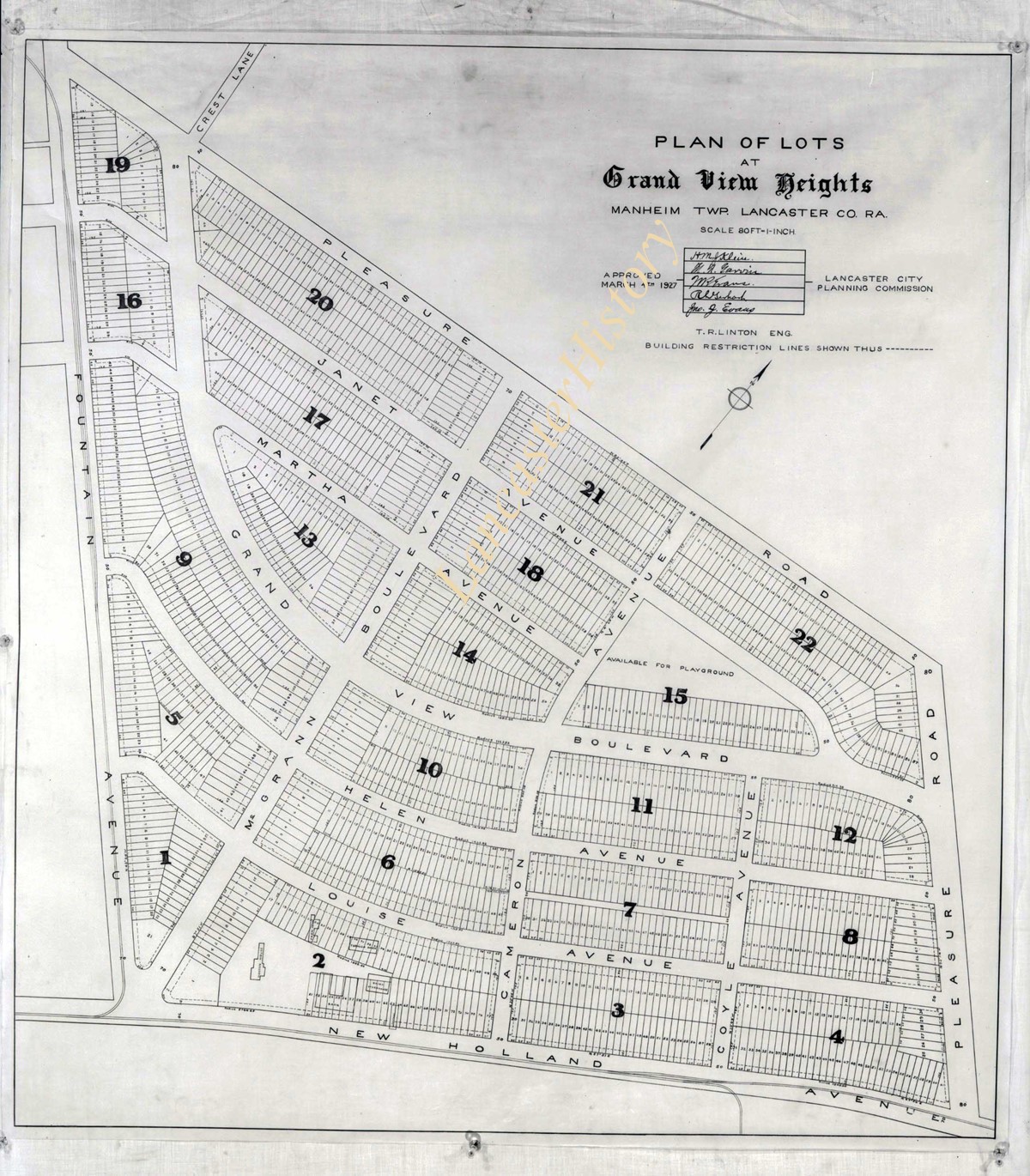
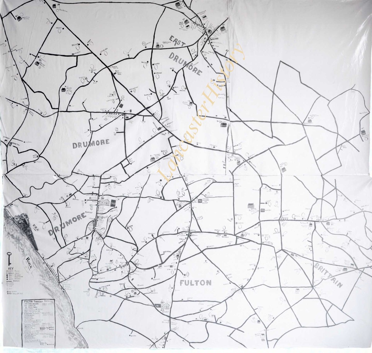
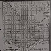
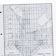
Plan for South East Ward also showing 1 drawing each of Odd Fellows Hall, Residence of Mrs. S. A. Porter, H. Leamans Rifle Works, Residence of Clement B. Grubb, German Reformed Church, Residence of Emanuel C. Reigard, Esq., and Residence of E. C. Darlington, Esq.. Locations of buildings are noted. 1 print only
Date Range
1931/05/25
Year Range From
1931
Storage Location
LancasterHistory, Lancaster, PA
People
Porter, Mrs. S. A.
Leaman, H.
Grubb, Clement B.
Reigard, Emanuel C.
Darlington, E. C.
Studio
Darmstaetter's
Subcategory
Documentary Artifact
Classification
Maps
Business & Commerce
Church Exterior
Civic Associations
Dwellings
Place
Lancaster
Object Name
Negative
Film Size
8 x 10 inches
Object ID
D-07-03-39
Negative Number
yes
Other Number
735-404
Images
Less detail
Collection
Darmstaetter Collection
Title
Photograph- Plan for South East Ward.
Object ID
D-07-03-38
Date Range
1931/05/25
  1 image  
Object Name
Negative
Collection
Darmstaetter Collection
Title
Photograph- Plan for South East Ward.
Description
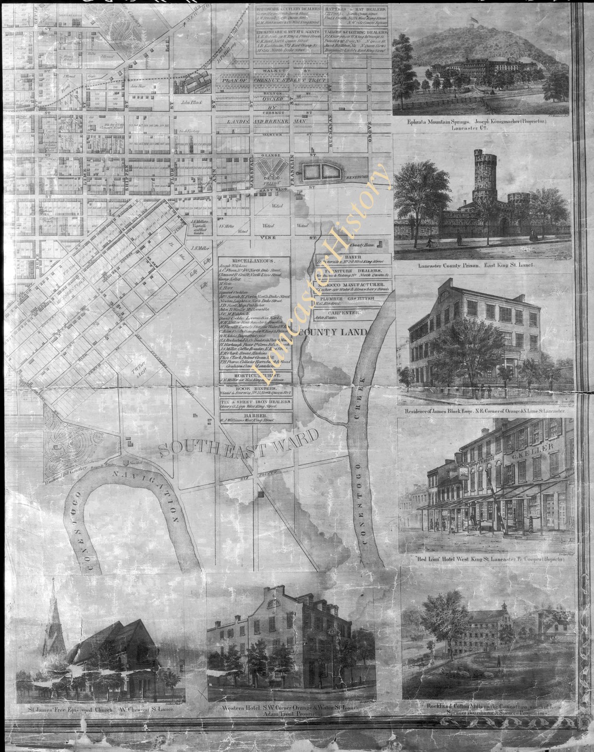
Plan for South East Ward, also showing 1 drawing each of St. James Free Episcopal Church, Western Hotel, Rockland Cotton Mill, Red Lion Hotel, Residence of James Black, Esq., Lancaster County Prison, Ephrata Mountain Springs--locations of buildings are noted. 1 print only
Date Range
1931/05/25
Year Range From
1931
Storage Location
LancasterHistory, Lancaster, PA
People
Black, James
Studio
Darmstaetter's
Subcategory
Documentary Artifact
Classification
Maps
Business & Commerce
Church Exterior
Dwellings
Government & Politics
Place
Lancaster
Object Name
Negative
Film Size
8 x 10 inches
Object ID
D-07-03-38
Negative Number
yes
Other Number
735-404
Images
Less detail
Collection
Darmstaetter Collection
Title
Photograph- Plan of North West Ward.
Object ID
D-07-03-37
Date Range
1931/05/25
  1 image  
Object Name
Negative
Collection
Darmstaetter Collection
Title
Photograph- Plan of North West Ward.
Description
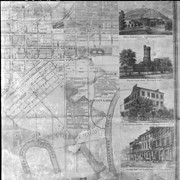
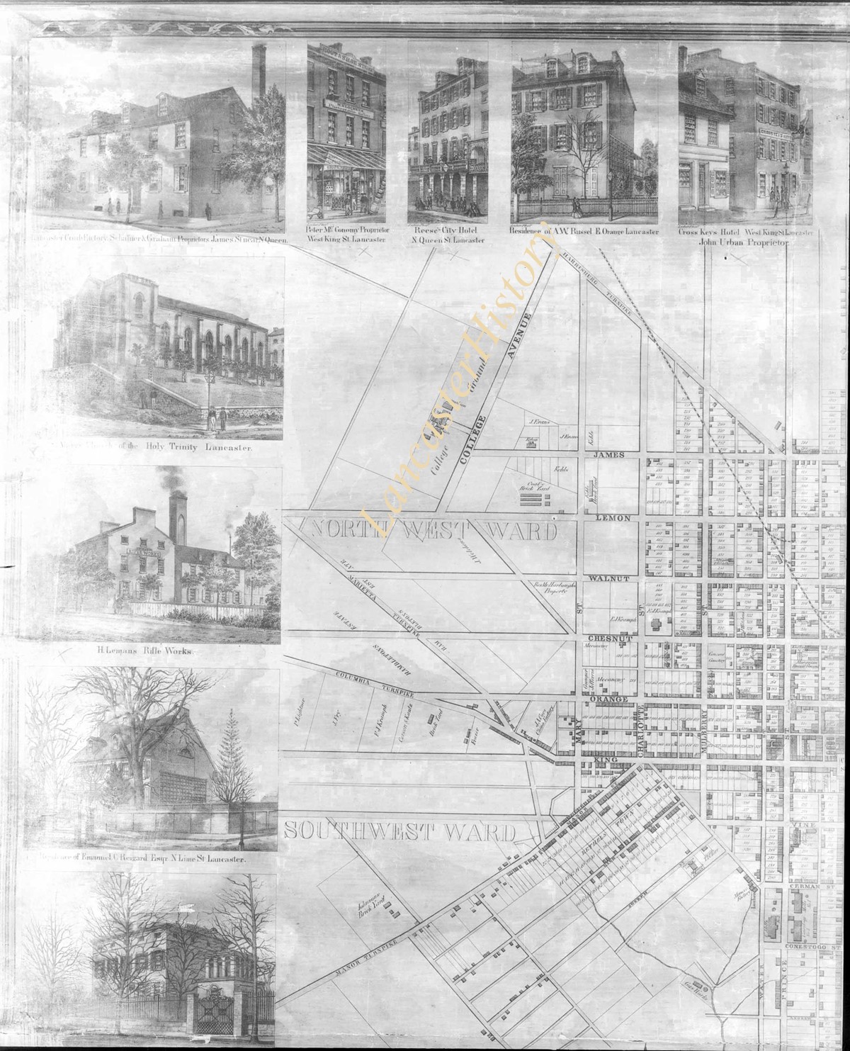
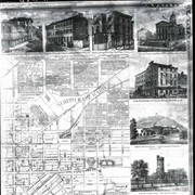
Plan of North West Ward also showing 1 drawing each of Cross Keys Hotel, Residence of A. W. Russel, Reese's City Hotel, McConomy Store, Lancaster Coach Factory, Lutheran Church of the Holy Trinity, H. Logman's (?) Rifle Works, Residence of Emanuel C. Reigard, Esq., and 1 unidentified building. Locations of buildings are noted. 1 print only
Date Range
1931/05/25
Year Range From
1931
Storage Location
LancasterHistory, Lancaster, PA
People
Russel, A. W.
Reigart, Emanuel C.
Studio
Darmstaetter's
Subcategory
Documentary Artifact
Classification
Maps
Business & Commerce
Dwellings
Church Exterior
Place
Lancaster
Object Name
Negative
Film Size
8 x 10 inches
Object ID
D-07-03-37
Negative Number
yes
Other Number
735-404
Images
Less detail
Collection
Darmstaetter Collection
Title
Photograph- Plan of the North East Ward.
Object ID
D-07-03-36
  1 image  
Object Name
Negative
Collection
Darmstaetter Collection
Title
Photograph- Plan of the North East Ward.
Description
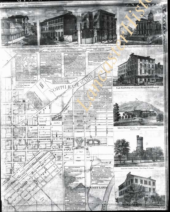
Plan of the North East Ward, also showing 1 drawing each of Fulton Hall, Lancaster Mercantile College, Residence of George K. Reid, Esq., Lancaster County Court House, Eagle Hotel, Ephrata Mountain Springs, Lancaster County Prison, and Residence of James Black, Esq. All buildings note locations and some have additional information. 1 print only
Storage Location
LancasterHistory, Lancaster, PA
People
Black, James
Reid, George K.
Studio
Darmstaetter's
Subcategory
Documentary Artifact
Classification
Maps
Business & Commerce
Dwellings
Government & Politics
Place
Lancaster
Object Name
Negative
Film Size
8 x 10 inches
Object ID
D-07-03-36
Negative Number
yes
Other Number
735-404
Images
Less detail
Collection
Darmstaetter Collection
Title
Photograph- Hand drawn map of various lots.
Object ID
D-07-03-35
Date Range
1928/12/24
  1 image  
Object Name
Negative
Collection
Darmstaetter Collection
Title
Photograph- Hand drawn map of various lots.
Description
Hand drawn map of various lots. 1 print only
Date Range
1928/12/24
Year Range From
1928
Storage Location
LancasterHistory, Lancaster, PA
Studio
Darmstaetter's
Subcategory
Documentary Artifact
Classification
Maps
Object Name
Negative
Film Size
10 x 8 inches
Object ID
D-07-03-35
Negative Number
yes
Other Number
690-1264
Images
Less detail
Collection
Darmstaetter Collection
Title
Photograph- Map of Lancaster city and vicinity.
Object ID
D-07-03-34
Date Range
1929/03/11
  1 image  
Object Name
Negative
Collection
Darmstaetter Collection
Title
Photograph- Map of Lancaster city and vicinity.
Description
Map of Lancaster city and vicinity. 1 print only
Date Range
1929/03/11
Year Range From
1929
Storage Location
LancasterHistory, Lancaster, PA
Studio
Darmstaetter's
Subcategory
Documentary Artifact
Classification
Maps
Place
Lancaster
Object Name
Negative
Film Size
10 x 8 inches
Object ID
D-07-03-34
Negative Number
yes
Other Number
690-229
Images
Less detail
Collection
Darmstaetter Collection
Title
Photograph- Map of City of Lancaster Regional Plan.
Object ID
D-07-03-33
Date Range
1929/04/22
  1 image  
Object Name
Negative
Collection
Darmstaetter Collection
Title
Photograph- Map of City of Lancaster Regional Plan.
Description
Map of City of Lancaster Regional Plan. 1 print only
Date Range
1929/04/22
Year Range From
1929
Storage Location
LancasterHistory, Lancaster, PA
Studio
Darmstaetter's
Subcategory
Documentary Artifact
Classification
Maps
Place
Lancaster
Object Name
Negative
Film Size
8 x 10 inches
Object ID
D-07-03-33
Negative Number
yes
Other Number
690-395
Images
Less detail
Collection
Darmstaetter Collection
Title
Photograph- Map--Probable extent of Commercial District.
Object ID
D-07-03-32
Date Range
1927/12/19
  1 image  
Object Name
Negative
Collection
Darmstaetter Collection
Title
Photograph- Map--Probable extent of Commercial District.
Description
Map--Probable extent of Commercial District. 1 print only
Date Range
1927/12/19
Year Range From
1927
Storage Location
LancasterHistory, Lancaster, PA
Studio
Darmstaetter's
Subcategory
Documentary Artifact
Classification
Maps
Place
Lancaster
Object Name
Negative
Film Size
8 x 10 inches
Object ID
D-07-03-32
Negative Number
yes
Other Number
670-472
Images
Less detail
Collection
Darmstaetter Collection
Title
Photograph- Map--Probable extent of Commericial District.
Object ID
D-07-03-31
  1 image  
Object Name
Negative
Collection
Darmstaetter Collection
Title
Photograph- Map--Probable extent of Commericial District.
Description
Map--Probable extent of Commericial District. 1 print only
Storage Location
LancasterHistory, Lancaster, PA
Studio
Darmstaetter's
Subcategory
Documentary Artifact
Classification
Maps
Place
Lancaster
Object Name
Negative
Film Size
5.25 x 5.5 inches
Object ID
D-07-03-31
Negative Number
yes
Other Number
670-143
Images
Less detail

20 records – page 1 of 1.