Skip header and navigation

Revise Search

10 records – page 1 of 1.

Edition
Latest revision 1970.
Date of Publication
1960.
Call Number
974.815 CONE 500
Responsibility
compiled by Lancaster County Assessment Deparrtment
Edition
Latest revision 1970.
Place of Publication
Lancaster, Pa
Publisher
Lancaster County Assessment Department ,
Date of Publication
1960.
Physical Description
1 map ; 71 x 102 cm.
Notes
Appears in: Real Estate Atlas of Lancaster County, Pennsylvania (LC 333.33 R288 1981).
Blue line print.
Contents
Map 18J.
Subjects
Tax assessment - Pennsylvania - Lancaster County
Real property - Pennsylvania - Lancaster County
Lancaster County (Pa.) - Maps.
Conestoga (Pa. : Township) - Maps.
Martic (Pa. : Township) - Maps.
Location
Lancaster History Library - Map
Call Number
974.815 CONE 500
Less detail
Edition
Latest revision 1968
Date of Publication
October 1, 1959.
Call Number
974.815 MART 500
Responsibility
compiled by Lancaster County Assessment Department
Edition
Latest revision 1968
Place of Publication
Lancaster, Pa
Publisher
Lancaster County Assessment Department,
Date of Publication
October 1, 1959.
Physical Description
1 map ; 71 x 102 cm.
Notes
Appears in "Real estate atlas of Lancaster County, Pennsylvania" LC 333.33 R288 1981.
Blue line print.
Contents
Map 19K12.
Subjects
Tax assessment - Pennsylvania - Lancaster County
Real property - Pennsylvania - Lancaster County
Landowners - Pennsylvania - Lancaster County
Martic (Pa. : Township) - Maps.
Location
Lancaster History Library - Map
Call Number
974.815 MART 500
Less detail
Edition
Latest revision 1984.
Date of Publication
June 6, 1964.
Call Number
974.815 MART 501
Responsibility
compiled by Lancaster County Assessment Department.
Edition
Latest revision 1984.
Place of Publication
Lancaster, Pa
Publisher
Lancaster County Assessment Department ,
Date of Publication
June 6, 1964.
Physical Description
1 map ; 71 x 102 cm.
Notes
Appears in: Real Estate Atlas of Lancaster County, Pennsylvania (LC 333.33 R288 1981).
Blue line print.
Contents
Map 18K.
Subjects
Tax assessment - Pennsylvania - Lancaster County
Real property - Pennsylvania - Lancaster County
Lancaster County (Pa.) - Maps.
Martic (Pa. : Township) - Maps.
Providence (Pa. : Township) - Maps.
Location
Lancaster History Library - Map
Call Number
974.815 MART 501
Less detail
Edition
Latest revision 1985.
Date of Publication
June 15, 1981.
Call Number
974.815 MART 502
Responsibility
compiled by Lancaster County Assessment Department.
Edition
Latest revision 1985.
Place of Publication
Lancaster, Pa
Publisher
Lancaster County Assessment Department ,
Date of Publication
June 15, 1981.
Physical Description
1 map ; 71 x 102 cm.
Notes
Appears in: Real Estate Atlas of Lancaster County, Pennsylvania (LC 333.33 R288 1981).
Blue line print.
Contents
Map 19K.
Subjects
Tax assessment - Pennsylvania - Lancaster County
Real property - Pennsylvania - Lancaster County
Lancaster County (Pa.) - Maps.
Martic (Pa. : Township) - Maps.
Providence (Pa. : Township) - Maps.
Location
Lancaster History Library - Map
Call Number
974.815 MART 502
Less detail

Draft of 150 acres 57 perches and allowance of land, the property of Mr. John Boslar: situate on Mount Nebo in Martic Township Lancaster County. Pa. also a draft of 65 acres neat measure surveyed off to Michael Gryder in December 1806...W. McCreary : The above divided per Joshua Scotts

https://collections.lancasterhistory.org/en/permalink/lhdo7539
Call Number
974.815 MART 102
Physical Description
1 map photocopy ; 20 x 32 cm.
Notes
Date of situation: 1806.
Draught of Boslar's and Gryders Land.
Original version: details unknown.
Subjects
Land grants - Pennsylvania - Martic Township
Real property - Pennsylvania - Martic Township
Martic Township (Pa.) - Maps.
Mount Nebo - Martic Township - Maps.
Location
Lancaster History Library - Map
Call Number
974.815 MART 102
Less detail

A general draught of land late of John Reads Esq., containing as therein set fourth, situate in Martic Township, Lancaster County, Pa.--October 18_2

https://collections.lancasterhistory.org/en/permalink/lhdo7517
Call Number
974.815 MART 104
Physical Description
1 map : photocopy ; 29 x 40 cm.
Notes
Map includes Read's Island, Burkholder's Island, Keagy's Rocks on Susquehanna River.
Names on mainland include: John Boslar, Jacob Huber, James Clark, James Coleman.
Original version: details unknown.
Subjects
Land grants - Pennsylvania - Martic Township
Real property - Pennsylvania - Martic Township
Martic Township (Pa.) - Maps.
Location
Lancaster History Library - Map
Call Number
974.815 MART 104
Less detail

Lardner's survey : survey'd Aug. 16-- 1834 per...[Lancaster County]

https://collections.lancasterhistory.org/en/permalink/lhdo7515
Call Number
974.815 LACI 140
Physical Description
1 map : photocopy ; 29 x 37 cm.
Notes
Property owners mentioned on map: Joshua Hagen, Jno. Boslar, John Campbell, Jacob Huber, Jas. Rice, Clark, Haddon, Sprought.
Original version : details of the original are unknown.
Subjects
Land grants - Pennsylvania - Martic Township
Real property - Pennsylvania - Martic Township
Martic Township (Pa.) - Maps.
Location
Lancaster History Library - Map
Call Number
974.815 LACI 140
Less detail
Corporate Author
Pennsylvania. Bureau of Land Records.
Date of Publication
1935.
Call Number
500 974
Corporate Author
Pennsylvania. Bureau of Land Records.
Place of Publication
Harrisburg
Date of Publication
1935.
Physical Description
map on sheet 111 x 107 cm.
Series
[Pennsylvania warrantee township tract maps, Lancaster County 25-5-1]
Notes
Photocopy.
"A connected draft of the tracts of land situated in Martic Township Lancaster County."
Scale 1:19,800;
Subjects
Land grants - Pennsylvania - Martic Township
Martic Township (Pa.) - Maps.
Warrant maps
Location
Lancaster History Library - Map
Call Number
500 974
Less detail
Collection
Abele and Shirk Family Photograph Collection
Title
Amish man sitting on the steps of The Old Woodshed
Object ID
ASF-01-04-01
Date Range
July 1990
  1 image  
Object Name
Print, Photographic
Collection
Abele and Shirk Family Photograph Collection
Title
Amish man sitting on the steps of The Old Woodshed
Description
Amish man sitting on the steps of The Old Woodshed in Intercourse.
Date Range
July 1990
Storage Location
LancasterHistory, Lancaster, PA
Storage Room
Archives West
Subject
Photographs
Classification
ASF-01-04-01
Search Terms
Amish
Intercourse, Leacock Twp.
Place
Leacock Twp.
Object Name
Print, Photographic
Original or Copy
Original
Print Size
3.5 x 5 inches
Object ID
ASF-01-04-01
Credit
Courtesy of LancasterHistory, Lancaster, Pennsylvania
Accession Number
2023.041
Images
Less detail
Collection
Abele and Shirk Family Photograph Collection
Title
Monument to Ulrich Shirck I
Object ID
ASF-01-04-02
Date Range
July 1990
  1 image  
Object Name
Print, Photographic
Collection
Abele and Shirk Family Photograph Collection
Title
Monument to Ulrich Shirck I
Description
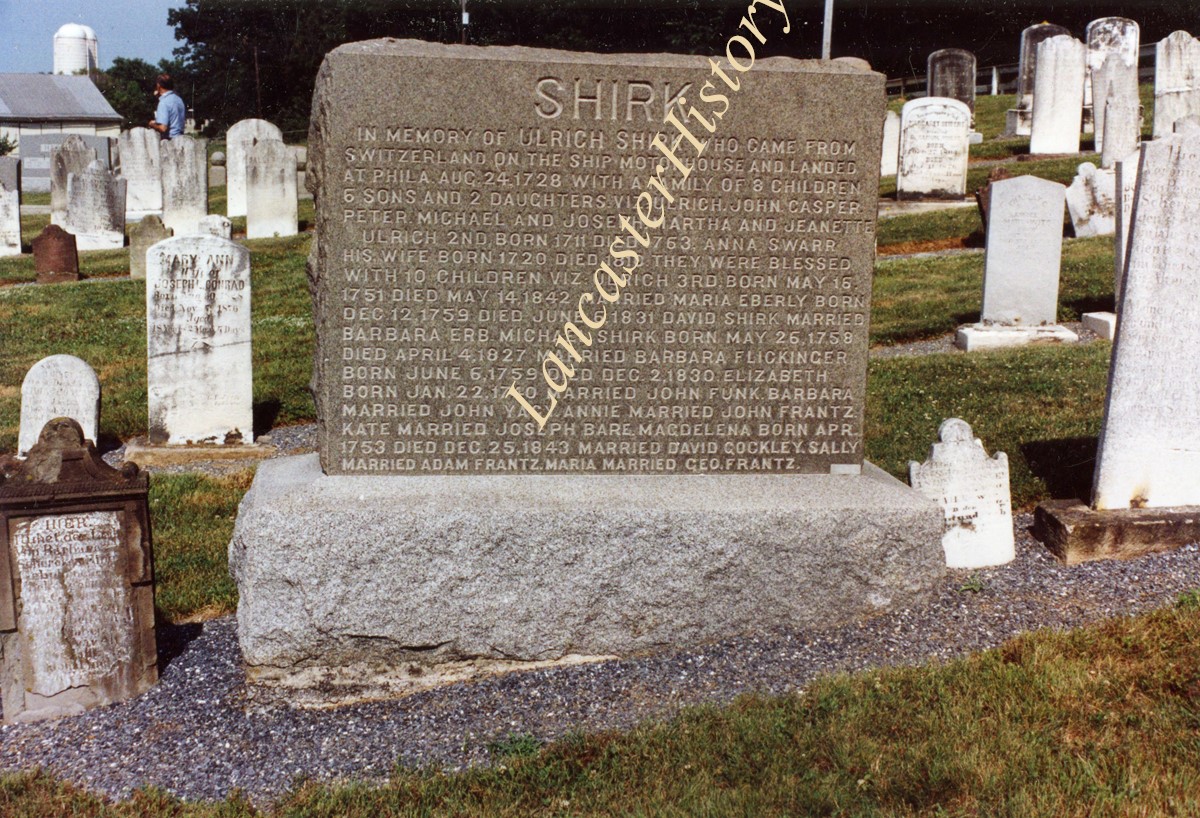
Monument to Ulrich Shirk I at Steinmetz Cemetery near Schoeneck, West Cocalico Twp. Written on back: "Commemorative stone for Ulrich Schurch I and family and descenedants. Steinmetz Cemetery, Lancaster County, Pa. Many early Shirks are buried here. July 1990."
Date Range
July 1990
Storage Location
LancasterHistory, Lancaster, PA
Storage Room
Archives West
People
Shirk, Ulrich
Subject
Photographs
Classification
ASF-01-04-02
Search Terms
Monuments
Cemeteries
Steinmetz Cemetery
Schoeneck, West Cocalico Twp.
Place
West Cocalico Twp.
Object Name
Print, Photographic
Original or Copy
Original
Print Size
4 x 6 inches
Object ID
ASF-01-04-02
Credit
Courtesy of LancasterHistory, Lancaster, Pennsylvania
Accession Number
2023.041
Images
Less detail

10 records – page 1 of 1.