Skip header and navigation

Revise Search

10 records – page 1 of 1.

Map of Lancaster City, Pa. and suburbs

https://collections.lancasterhistory.org/en/permalink/lhdo15007
Author
Herr, H. N.
Date of Publication
1898.
Call Number
974.815 LACI 519
Responsibility
compiled and drawn by H.N. Herr ; from original surveys and measurements of A.A. Herr.
Author
Herr, H. N.
Place of Publication
Baltimore, Md
Publisher
Wm. A. Flamm & Co.,
Date of Publication
1898.
Physical Description
1 map ; 80 x 98 cm. on shet 87 x 107 cm., folded to 15 x 10 cm.
Subjects
Lancaster (Pa.) - Maps.
Additional Author
Herr, A. A.
Location
Lancaster History Library - Map
Call Number
974.815 LACI 519
Less detail

Map of Lancaster County, Pa. showing lines of Conestoga Traction Company

https://collections.lancasterhistory.org/en/permalink/lhdo15838
Corporate Author
Conestoga Traction Company.
Date of Publication
1909.
Call Number
974.815 LACO 141
  1 document  
Responsibility
courtesy, Conestoga Traction Company.
Corporate Author
Conestoga Traction Company.
Place of Publication
[Lititz, Pa
Publisher
Express Printing Co.,],
Date of Publication
1909.
Physical Description
1 map ; 23 x 27 cm.
Notes
Scale on map: 1 in. = 4.61 miles.
"Supplement of the Pennsylvania German, August, 1909."
"Figures give population of townships."
Reduced reprinting of original map.
Subjects
Conestoga Traction Company.
Electric railroads - Pennsylvania - Lancaster County - Maps.
Lancaster County (Pa.) - Population - Maps.
Lancaster County (Pa.) - Maps.
Location
Lancaster History Library - Map
Call Number
974.815 LACO 141
Documents

map_974.815_LACO_141_.pdf

Read PDF Download PDF
Less detail

Map of Lancaster County, Pennsylvania

https://collections.lancasterhistory.org/en/permalink/lhdo19526
Author
Scott, Joshua.
Date of Publication
1824.
Call Number
912.74815 L244 1824
  1 website  
Responsibility
respectfully dedicated to the inhabitants by Joshua Scott.
Author
Scott, Joshua.
Place of Publication
Lancaster
Publisher
[s.n.],
Date of Publication
1824.
Physical Description
1 map : hand col., cloth backing ; 87 x 115 cm., folded to 93 x 61 cm.
Notes
General-content county map also showing election districts.
Hand col. to emphasize township boundaries and territories.
Relief shown by hachures.
Orientated with north toward the upper left.
Prime meridian: Washington (D.C.).
Published "Lancaster January 1st 1824".
Originally printed on 4 sheets (later conjoined).
Copy 2: From the collections of the Heritage Center, P05.29.1.
LC Land ownership maps,
Copy 2: green boards.
Copy 1: Marble boards, three-quarater red leather, spine taped.
Subjects
Election districts - Pennsylvania - Lancaster County - Maps.
Landowners - Pennsylvania - Lancaster County - Maps.
Election districts.
Landowners.
Lancaster County (Pa.) - Maps.
Pennsylvania - Lancaster County.
Maps.
Location
Lancaster History Library - Rare Books
Call Number
912.74815 L244 1824
Websites
Less detail

Map of Lancaster County Pennsylvania

https://collections.lancasterhistory.org/en/permalink/lhdo5161
Date of Publication
1821.
Call Number
974.815 LACO 110
Place of Publication
York, Pa
Publisher
William Wagner ,
Date of Publication
1821.
Physical Description
1 map : photocopy ; 41 x 55 cm.
Notes
Relief shown by hachures.
"Entered according to Act of Congress August 27, 1821 by W. Wagner of the State of Penna".
Shows locations of mills, furnaces, churches, township lines, turnpikes and roads.
Subjects
Lancaster County (Pa.) - Maps.
Location
Lancaster History Library - Map
Call Number
974.815 LACO 110
Less detail

[Map of Lancaster, Pa. copied from Sanborn Fire Insurance maps.]

https://collections.lancasterhistory.org/en/permalink/lhdo1728
Date of Publication
1897.
Call Number
974.815 LACI 117
Place of Publication
[s.l.]
Publisher
[s.n.] ,
Date of Publication
1897.
Physical Description
1 map : photocopy ; 43 x 45 cm.
Notes
Photocopy from Sanborn Fire Insurance maps, see microfilm.
Subjects
Insurance, Fire - Pennsylvania - Lancaster
Lancaster (Pa.) - Maps.
Location
Lancaster History Library - Map
Call Number
974.815 LACI 117
Less detail

Map showing location and date of the earliest highways leading from the Delaware and Schulkill Rivers to the Susquehanna River and it's branches / by H. Frank Eshleman

https://collections.lancasterhistory.org/en/permalink/lhdo15534
Author
Eshleman, H. Frank
Date of Publication
1907.
Call Number
974.815 SEPA 100
  1 document  
Author
Eshleman, H. Frank
Place of Publication
Lancaster, Pa
Publisher
H. Frank Eshleman,
Date of Publication
1907.
Physical Description
1 map ; 22 x 41 cm.
Notes
Scale on map [ca. 1:418,176]. 3/4 in. = 5 mi.
May be a reduced reproduction of the original map.
Subjects
Roads - Pennsylvania - Lancaster County - Maps.
Roads - Pennsylvania - Chester County - Maps.
Roads - Pennsylvania - Delaware County - Maps.
Lancaster County (Pa.) - Maps.
Chester County (Pa.) - Maps.
Delaware County (Pa.) - Maps.
Location
Lancaster History Library - Map
Call Number
974.815 SEPA 100
Documents

map_974.815_SEPA_100_.pdf

Read PDF Download PDF
Less detail

Plan of Woodward Hill Cemetery, Lancaster, Pa

https://collections.lancasterhistory.org/en/permalink/lhdo3292
Date of Publication
[ca. 1900].
Call Number
974.815 LACI 703
Place of Publication
[S.l.]
Publisher
[s.n.] ,
Date of Publication
[ca. 1900].
Physical Description
1 map : photocopy : 58 x 80 cm.
Notes
Gives section and lot numbers.
Subjects
Woodward Hill cemetery (Lancaster, Pa.) - Maps.
Cemeteries - Pennsylvania - Lancaster
Lancaster (Pa.) - Maps.
Location
Lancaster History Library - Map
Call Number
974.815 LACI 703
Less detail

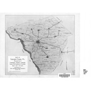
A reference map of Lancaster County, Pennsylvania showing the location and distances of the city, townships, boroughs, post-office and villages, together with the main roads (turnpikes), railroads and railroad stations, also the population of each township and borough as per census of 1890

https://collections.lancasterhistory.org/en/permalink/lhdo1711
Date of Publication
1891
Call Number
974.815 LACO 140
Place of Publication
Lancaster, Pa
Publisher
Burk & McFetridge,lith., Reference Map Co.,
Date of Publication
1891
Physical Description
1 map : linen ; 54 x 56 cm.
Notes
Shows radial distances from Lancaster. Relief shown by hachures. Cloth map. Includes index of places by township.
Subjects
Toll roads - Pennsylvania - Lancaster County
Railroads - Pennsylvania - Lancaster County
Lancaster County (Pa.) - Maps.
Location
Lancaster History Library - Map
Call Number
974.815 LACO 140
Less detail

Road and township map of Lancaster County Pennsylvania

https://collections.lancasterhistory.org/en/permalink/lhdo7219
Date of Publication
1892.
Call Number
974.815 LACO 132
Place of Publication
Lancaster, Pa
Publisher
County Pub. Co. : L.B. Herr,
Date of Publication
1892.
Physical Description
1 map : col. ; 21 x 55 cm., folded to 14 x 10 cm.
Notes
Date of situation: 1892.
Includes index to towns, post office and railroad stations.
"Entered according to Act of Congress in the year 1892, by A.S. Johns and T.J. Hughes".
Subjects
Post office buildings - Pennsylvania - Lancaster County - Maps.
Lancaster County (Pa.) - Maps.
Location
Lancaster History Library - Map
Call Number
974.815 LACO 132
Less detail

Road and township map of Lancaster County, Pennsylvania

https://collections.lancasterhistory.org/en/permalink/lhdo5129
Date of Publication
1892.
Call Number
974.815 LACO 103
Place of Publication
Lancaster Pa
Publisher
County Publishing Co.,
Date of Publication
1892.
Physical Description
1 map : col. ; 51 x 55 cm.
Notes
Shows distance radially. Index to towns, post offices, railroad stations and points of interest.
Subjects
Lancaster County, (Pa.) - Maps
Location
Lancaster History Library - Map
Call Number
974.815 LACO 103
Less detail

10 records – page 1 of 1.