It appears no script is enabled within your browser. Please enable JavaScript to use this site.
Skip header and navigation
Toggle navigation
Collections
Search
Help
Privacy
Your Selections:
0
Items
Staff Login
Revise Search
Revise Search
Revise search
Search
Data Source
Library
10469
Photographs
Archives
1590
Artifacts
31
×
Data Source
All
A
B
C
D
E
F
G
H
I
J
K
L
M
N
O
P
Q
R
S
T
U
V
W
X
Y
Z
Sort
By Count
Alphabetical
Filtered by
Filter
Loading...
Collection
General Collection
454
Album 82 Donald A. Groff Photograph Album
304
Henry Kauffman Photograph Collection
153
Discover Lancaster Photograph Collection
151
Henry Carter Album
136
Fulton Opera House Collection
84
Darmstaetter Collection
71
Lancaster Recreation Commission Photograph Collection
45
Mills Album
35
James Buchanan Foundation Photograph Collection
31
Heritage Center Collection
29
Mildred Shopf Smiley Photograph Collection
20
More
×
Collection
All
A
B
C
D
E
F
G
H
I
J
K
L
M
N
O
P
Q
R
S
T
U
V
W
X
Y
Z
Sort
By Count
Alphabetical
Filtered by
Filter
Loading...
Subject
Documentary Artifact
1266
Photographs
348
Military
321
Pennsylvania National Guard
301
Government
297
Politics
267
Ephrata Cloister
210
United States Army
209
Politicians
150
Legislature
136
Mount Gretna, Lebanon County, Pennsylvania
120
World War II
95
More
×
Subject
All
A
B
C
D
E
F
G
H
I
J
K
L
M
N
O
P
Q
R
S
T
U
V
W
X
Y
Z
Sort
By Count
Alphabetical
Filtered by
Filter
Loading...
Name
Darmstaetter's
81
Casey, Bob
73
Krone, Herbert Brickley
53
Buchanan, James
23
Groff, Donald A.
18
Bond, George Ross
11
Getz, Helen
10
Saylor, B. Frank
8
Heiges, George L.
7
Stork, Janice
7
Barton, R. Harold
6
Bair, Milton Walter
5
More
×
Name
All
A
B
C
D
E
F
G
H
I
J
K
L
M
N
O
P
Q
R
S
T
U
V
W
X
Y
Z
Sort
By Count
Alphabetical
Filtered by
Filter
Loading...
Place
Lancaster
192
Ephrata
181
Lebanon County, Pennsylvania
78
East Lampeter Twp.
60
Berks County, Pennsylvania
42
Ephrata Twp.
32
Hohenfeld, Germany
31
Franklin County, Pennsylvania
30
Rapho Twp.
30
Fort Stewart, Georgia
28
Manheim Twp.
28
Camp Pendleton, Accomack County, Virginia
24
More
×
Place
All
A
B
C
D
E
F
G
H
I
J
K
L
M
N
O
P
Q
R
S
T
U
V
W
X
Y
Z
Sort
By Count
Alphabetical
Filtered by
Filter
Loading...
Decade
1740s
1
1800s
1
1810s
1
1840s
2
1850s
26
1860s
4
1870s
138
1880s
5
1890s
22
1900s
58
1910s
33
1920s
73
1930s
77
1940s
201
1950s
145
1960s
19
1970s
86
1980s
17
1990s
148
2000s
10
×
Decade
All
A
B
C
D
E
F
G
H
I
J
K
L
M
N
O
P
Q
R
S
T
U
V
W
X
Y
Z
Sort
By Count
Alphabetical
Filtered by
Filter
Loading...
Material
Print, Photographic
1430
Transparency, Slide
184
Negative
126
Postcard
15
Negative, Glass Plate
13
Transparency, Lantern Slide
7
×
Material
All
A
B
C
D
E
F
G
H
I
J
K
L
M
N
O
P
Q
R
S
T
U
V
W
X
Y
Z
Sort
By Count
Alphabetical
Filtered by
Filter
Loading...
Online Media
Image
1767
×
Online Media
All
A
B
C
D
E
F
G
H
I
J
K
L
M
N
O
P
Q
R
S
T
U
V
W
X
Y
Z
Sort
By Count
Alphabetical
Filtered by
Filter
Loading...
Advanced Search
Help
more like: LHDO15528
Photographs
Sorted by
Title
Sort by Relevance
Expand All
Collapse All
List View
Gallery View
Print
10 records – page 1 of 1.
Prev
Next
Toggle Full Record
Negative
https://collections.lancasterhistory.org/en/permalink/fa215926-2a98-4cfe-9fc4-359473170570
Collection
Wilton - Armetale Photograph Collection
Object ID
WI-01-06-02
Date Range
c. 1977
More detail
1 image
Object Name
Negative
Collection
Wilton - Armetale Photograph Collection
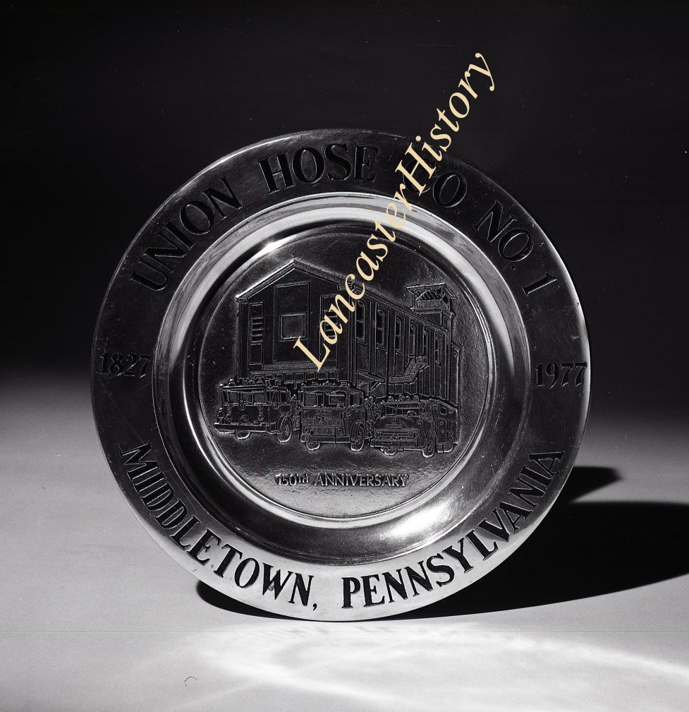
Description
Union Hose Company No. 1, Middletown, commemorative plate
Date Range
c. 1977
Storage Location
LancasterHistory, Lancaster, PA
Search Terms
Plates
Firefighting
Middletown, Dauphin County, Pennsylvania
Object Name
Negative
Print Size
4 x 5 inches
Object ID
WI-01-06-02
Images
Less detail
More Like This
Permalink
Toggle Full Record
Negative
https://collections.lancasterhistory.org/en/permalink/cf00626e-5af6-4bd0-9b93-933144462914
Collection
General Collection
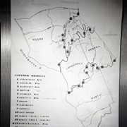
Title
Map showing covered bridges in Manor, Conestoga, Pequea and Martic Townships
Object ID
1-21-01-68
More detail
1 image
Object Name
Negative
Collection
General Collection
Title
Map showing covered bridges in Manor, Conestoga, Pequea and Martic Townships
Description
Map of covered bridges in Manor, Conestoga, Pequea and Martic Townships
Storage Location
LancasterHistory, Lancaster, PA
Subject
Photographs
Classification
1-21-01-68
Search Terms
Covered bridges
Maps
Object Name
Negative
Film Size
4 x 5 inches
Original or Copy
Original
Object ID
1-21-01-68
Images
Less detail
More Like This
Permalink
Toggle Full Record
Negative
https://collections.lancasterhistory.org/en/permalink/677d7a8b-d556-48d0-ab78-711877590385
Collection
General Collection
Object ID
1-10-07-35
More detail
1 image
Object Name
Negative
Collection
General Collection
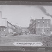
Description
Pennsylvania Soap Company, also known as Miller's Soap Works
Storage Location
LancasterHistory, Lancaster, PA
Subcategory
Documentary Artifact
Search Terms
Pennsylvania Soap Company
Miller's Soap Works
Object Name
Negative
Film Size
4 x 5 inches
Object ID
1-10-07-35
Images
Less detail
More Like This
Permalink
Toggle Full Record
Negative
https://collections.lancasterhistory.org/en/permalink/c646568d-8c52-406a-ba0e-558305303232
Collection
Darmstaetter Collection
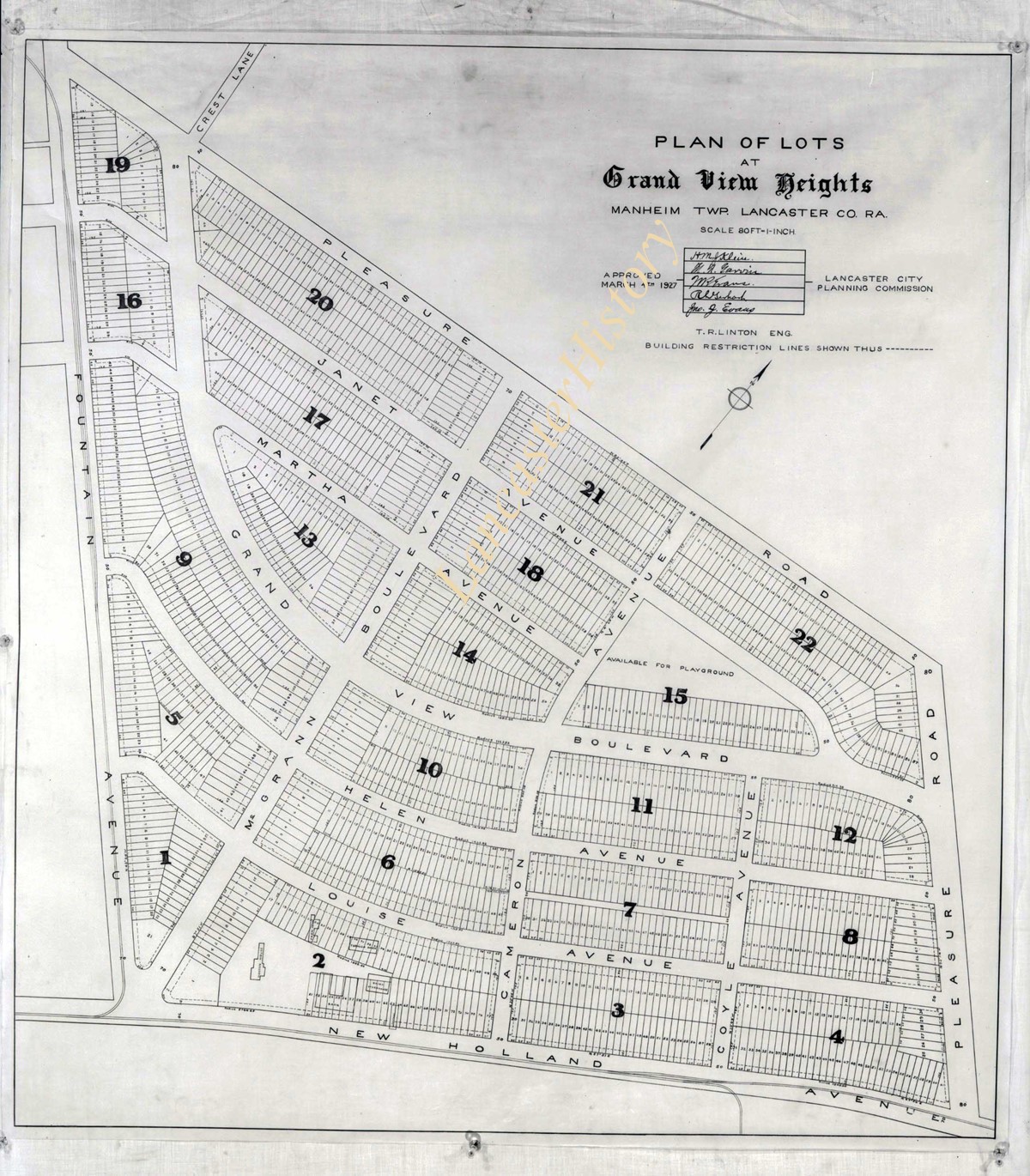
Title
Photograph- Plan for lots in Grandview Heights.
Object ID
D-07-03-56
More detail
1 image
Object Name
Negative
Collection
Darmstaetter Collection
Title
Photograph- Plan for lots in Grandview Heights.
Description
Plan for lots in Grandview Heights. 1 print only
Storage Location
LancasterHistory, Lancaster, PA
Studio
Darmstaetter's
Subcategory
Documentary Artifact
Classification
Maps
Place
Manheim Twp.
Object Name
Negative
Film Size
8 x 10 inches
Object ID
D-07-03-56
Negative Number
yes
Other Number
660-870
Images
Less detail
More Like This
Permalink
Toggle Full Record
Negative
https://collections.lancasterhistory.org/en/permalink/7723bebb-3aa3-432f-abec-170944938900
Collection
Darmstaetter Collection
Title
Photograph- Plan for Greater Lancaster showing Wheatland Hills.
Object ID
D-07-03-55
Date Range
January 24, 1927
More detail
1 image
Object Name
Negative
Collection
Darmstaetter Collection
Title
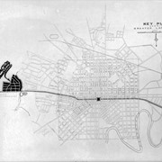
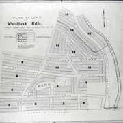
Photograph- Plan for Greater Lancaster showing Wheatland Hills.
Description
Plan for Greater Lancaster showing Wheatland Hills. 1 print only
Date Range
January 24, 1927
Storage Location
LancasterHistory, Lancaster, PA
Studio
Darmstaetter's
Subcategory
Documentary Artifact
Classification
Maps
Place
East Hempfield Twp.
Object Name
Negative
Film Size
10 x 8 inches
Object ID
D-07-03-55
Negative Number
yes
Other Number
660-257
Images
Less detail
More Like This
Permalink
Toggle Full Record
Negative
https://collections.lancasterhistory.org/en/permalink/7b4479be-5ce0-4aed-b9d1-296882065808
Collection
Darmstaetter Collection
Title
Photograph- Plan of lots at Wheatland Hills.
Object ID
D-07-03-54
More detail
1 image
Object Name
Negative
Collection
Darmstaetter Collection
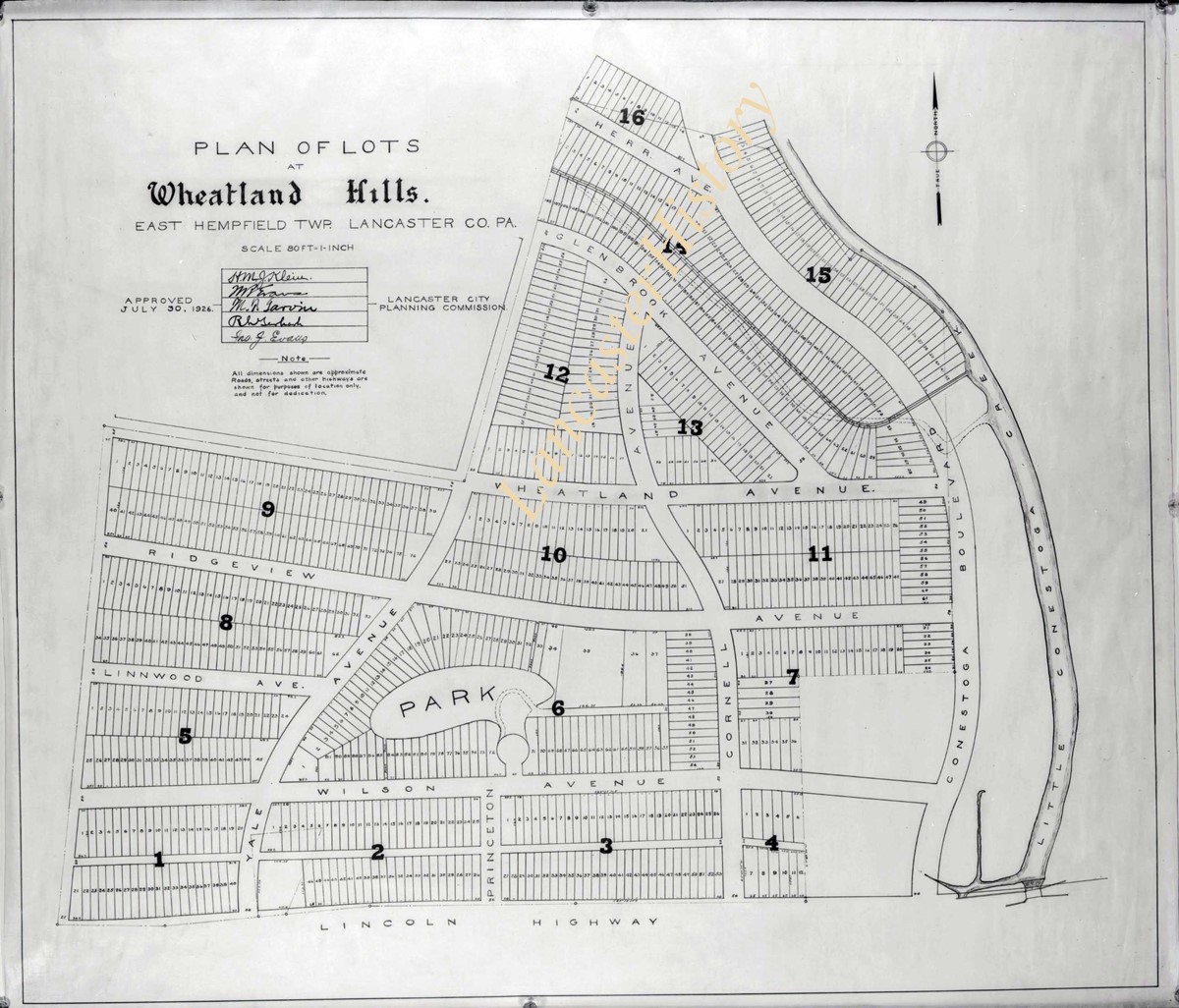
Title
Photograph- Plan of lots at Wheatland Hills.
Description
Plan of lots at Wheatland Hills. 1 print only
Storage Location
LancasterHistory, Lancaster, PA
Studio
Darmstaetter's
Subcategory
Documentary Artifact
Classification
Maps
Place
East Hempfield Twp.
Object Name
Negative
Film Size
10 x 8 inches
Object ID
D-07-03-54
Negative Number
yes
Other Number
660-180
Images
Less detail
More Like This
Permalink
Toggle Full Record
Negative
https://collections.lancasterhistory.org/en/permalink/cfeaaee4-cdc4-4b21-aef9-829150874936
Collection
Darmstaetter Collection
Title
Photograph- Map of Lancaster County.
Object ID
D-07-03-53
Date Range
1926/02/22
More detail
1 image
Object Name
Negative
Collection
Darmstaetter Collection
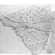
Title
Photograph- Map of Lancaster County.
Description
Map of Lancaster County. 1 print only
Date Range
1926/02/22
Year Range From
1926
Storage Location
LancasterHistory, Lancaster, PA
Studio
Darmstaetter's
Subcategory
Documentary Artifact
Classification
Maps
Place
Lancaster County
Object Name
Negative
Film Size
10 x 8 inches
Object ID
D-07-03-53
Negative Number
yes
Other Number
642-435
Images
Less detail
More Like This
Permalink
Toggle Full Record
Negative
https://collections.lancasterhistory.org/en/permalink/23988159-db5d-4ca5-b01e-153188656558
Collection
Darmstaetter Collection
Title
Photograph- Map showing Berks, Lebanon, York, Chester, and Lancaster Counties.
Object ID
D-07-03-52
Date Range
1928/10/01
More detail
1 image
Object Name
Negative
Collection
Darmstaetter Collection
Title
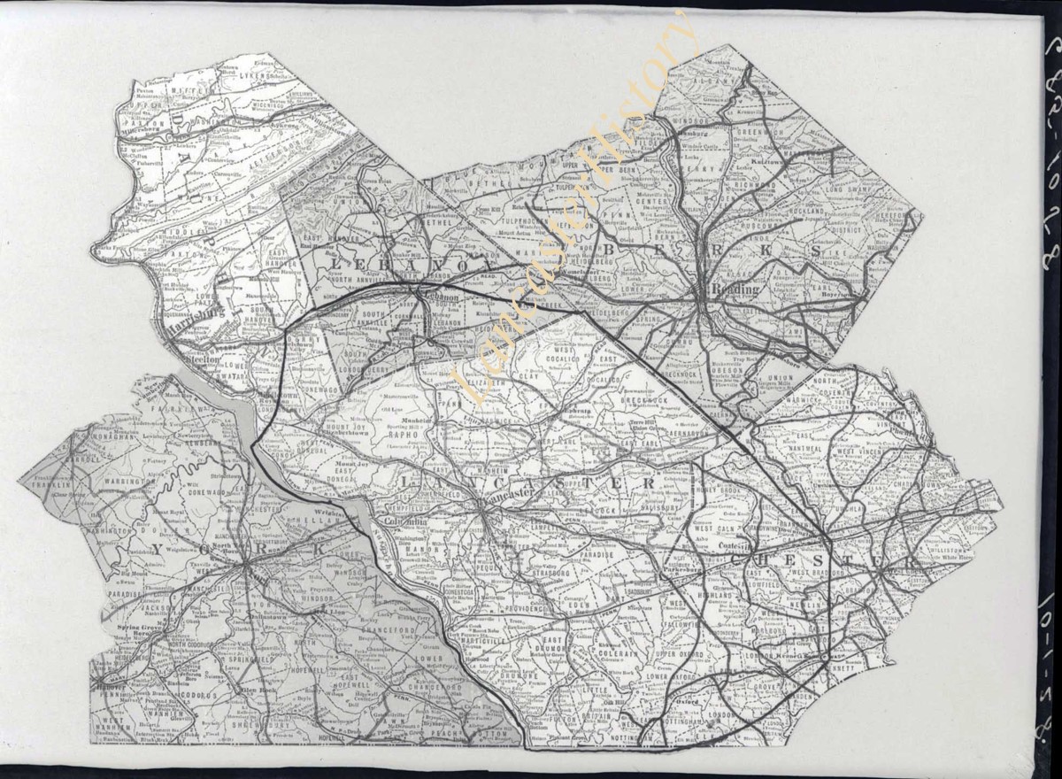
Photograph- Map showing Berks, Lebanon, York, Chester, and Lancaster Counties.
Description
Map showing Berks, Lebanon, York, Chester, and Lancaster Counties. 1 print only
Date Range
1928/10/01
Year Range From
1928
Storage Location
LancasterHistory, Lancaster, PA
Studio
Darmstaetter's
Subcategory
Documentary Artifact
Classification
Maps
Object Name
Negative
Film Size
6.5 x 5 inches
Object ID
D-07-03-52
Negative Number
yes
Other Number
685-1058
Images
Less detail
More Like This
Permalink
Toggle Full Record
Negative
https://collections.lancasterhistory.org/en/permalink/7bf4d352-83bc-411e-b713-389752566549
Collection
Darmstaetter Collection
Title
Photograph- Map showing county system of highways as adopted by the Lancaster Automobile Club, May 1924.
Object ID
D-07-03-51
Date Range
1924/05/19
More detail
1 image
Object Name
Negative
Collection
Darmstaetter Collection
Title
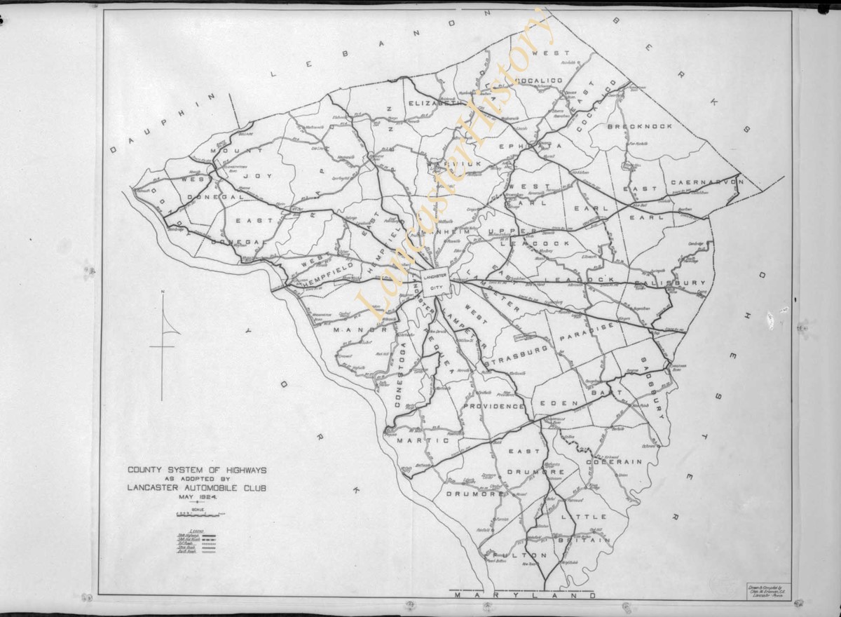
Photograph- Map showing county system of highways as adopted by the Lancaster Automobile Club, May 1924.
Description
Map showing county system of highways as adopted by the Lancaster Automobile Club, May 1924. 1 print only
Date Range
1924/05/19
Year Range From
1924
Storage Location
LancasterHistory, Lancaster, PA
Studio
Darmstaetter's
Subcategory
Documentary Artifact
Classification
Maps
Place
Lancaster County
Object Name
Negative
Film Size
6.5 x 5 inches
Object ID
D-07-03-51
Negative Number
yes
Other Number
613-1493
Images
Less detail
More Like This
Permalink
Toggle Full Record
Negative
https://collections.lancasterhistory.org/en/permalink/970653d0-e548-4cad-a0d2-755934254994
Collection
Darmstaetter Collection
Title
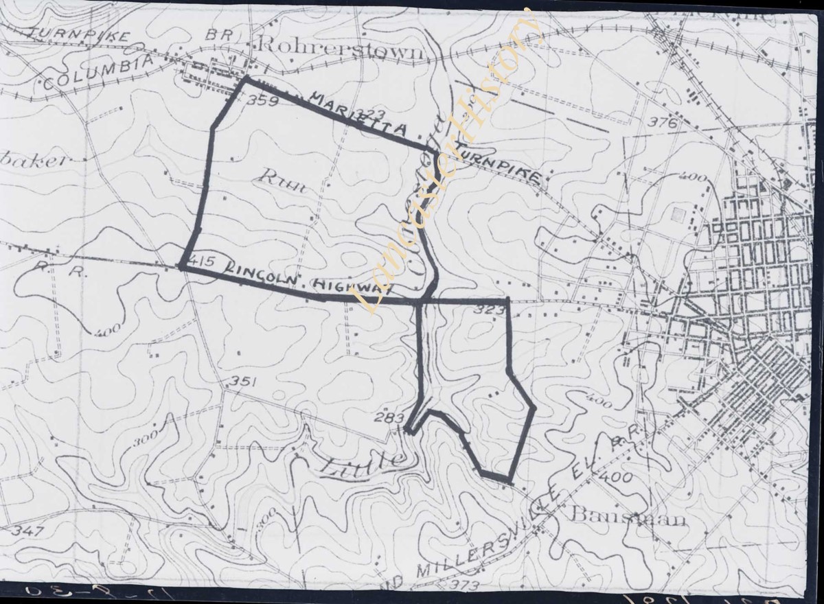
Photograph- Map showing topography and Lincoln Highway and Marietta Turnpike.
Object ID
D-07-03-50
Date Range
1930/17/09
More detail
1 image
Object Name
Negative
Collection
Darmstaetter Collection
Title
Photograph- Map showing topography and Lincoln Highway and Marietta Turnpike.
Description
Map showing topography and Lincoln Highway and Marietta Turnpike. 1 print only
Date Range
1930/17/09
Year Range From
1930
Storage Location
LancasterHistory, Lancaster, PA
Studio
Darmstaetter's
Subcategory
Documentary Artifact
Classification
Maps
Place
Lancaster County
Object Name
Negative
Film Size
6.5 x 5 inches
Object ID
D-07-03-50
Negative Number
yes
Other Number
721-1796
Images
Less detail
More Like This
Permalink
10 records – page 1 of 1.
Prev
Next