Skip header and navigation

Revise Search

7129 records – page 1 of 713.

Along the western Brandywine

https://collections.lancasterhistory.org/en/permalink/lhdo6012
Author
MacElree, Wilmer W.,
Edition
2d ed.
Date of Publication
1912.
Call Number
974.813 M141b
  1 website  
Responsibility
by Wilmer W. MacElree.
Author
MacElree, Wilmer W.,
Edition
2d ed.
Place of Publication
[West Chester, Pa
Publisher
F. S. Hickman, printer]
Date of Publication
1912.
Physical Description
199 p. front., illus., plates, ports., maps (1 fold.) facsims. 28 cm.
Summary
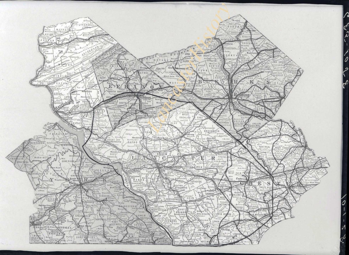
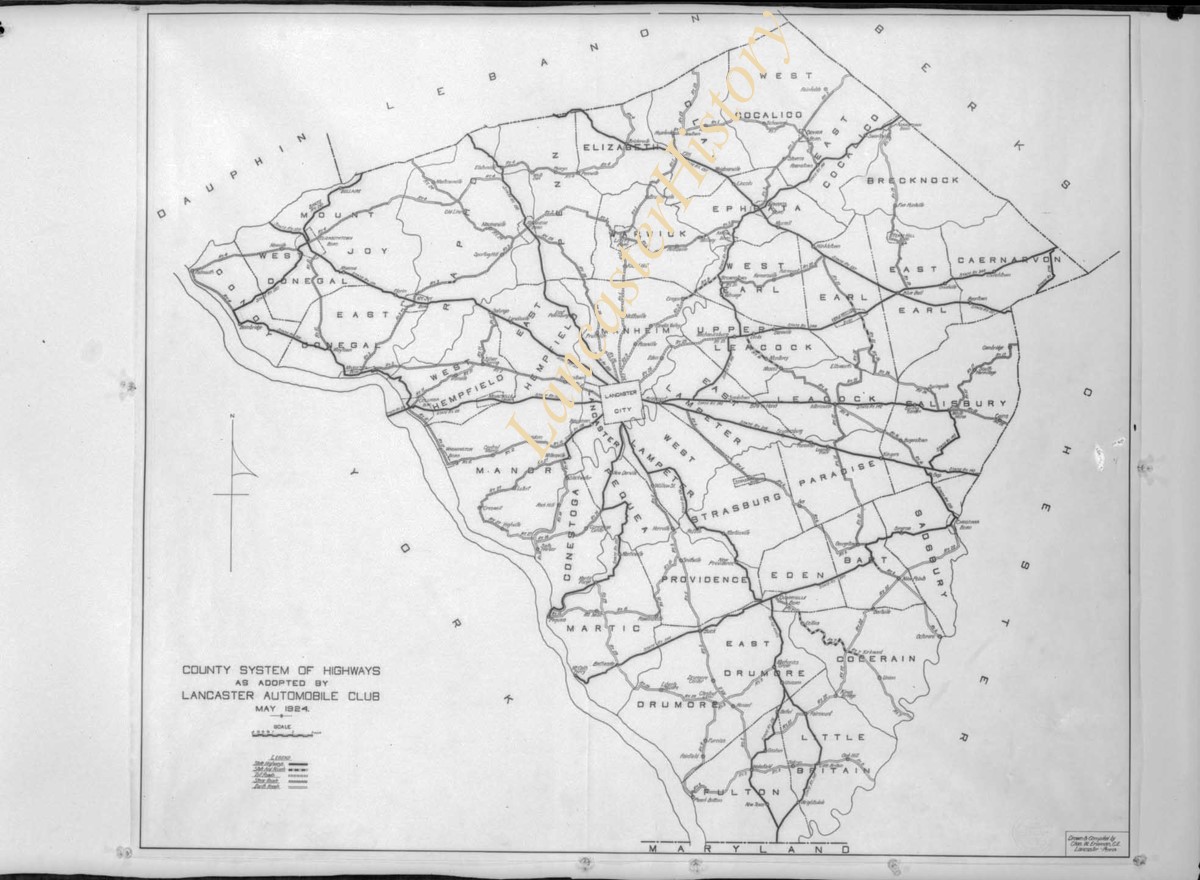
A 1909 tour of the towns and places near the west branch of the Brandywine Creek, it includes Honey Brook and the railroad that once ran through it, Coatesville, Hibernia, Icedale, West Chester, Chadds Ford, and many other sites in Chester County, northern Maryland, and Delaware.
Subjects
Brandywine, Battle of, 1777.
Chester County (Pa.) - Description and travel.
Brandywine Creek.
Location
Lancaster History Library - Book
Call Number
974.813 M141b
Websites
Less detail

Around the boundaries of Chester county, by Wilmer W. MacElree

https://collections.lancasterhistory.org/en/permalink/lhdo6403
Author
MacElree, Wilmer W.,
Date of Publication
1934.
Call Number
974.813 M141
Author
MacElree, Wilmer W.,
Place of Publication
West Chester, Pa
Date of Publication
1934.
Physical Description
2 p. β., 9-600 p. illus., (incl. ports., facsims.) plates, maps (1 fold.) diagr. 23 cm.
Subjects
Chester County (Pa.) - Description and travel.
Chester County (Pa.) - Historic houses, etc.
Location
Lancaster History Library - Book
Call Number
974.813 M141
Less detail

Down the Eastern and up the Black Brandywine

https://collections.lancasterhistory.org/en/permalink/lhdo8274
Author
MacElree, Wilmer W.,
Date of Publication
1906.
Call Number
974.813 M141d
  1 website  
Responsibility
by Wilmer W. Mac Elree.
Author
MacElree, Wilmer W.,
Place of Publication
[West Chester, Pa
Publisher
F. S. Hickman, printer]
Date of Publication
1906.
Physical Description
176 p. col. front., illus., plates. 28 cm.
Summary
The author gives a tour of this area in Chester County , PA, as it was in the early 1900's.
Subjects
Brandywine Creek.
Chester County (Pa.) - Description and travel.
Location
Lancaster History Library - Book
Call Number
974.813 M141d
Websites
Less detail
Collection
Darmstaetter Collection
Title
Photograph- Plan for lots in Grandview Heights.
Object ID
D-07-03-56
  1 image  
Object Name
Negative
Collection
Darmstaetter Collection
Title
Photograph- Plan for lots in Grandview Heights.
Description
Plan for lots in Grandview Heights. 1 print only
Storage Location
LancasterHistory, Lancaster, PA
Studio
Darmstaetter's
Subcategory
Documentary Artifact
Classification
Maps
Place
Manheim Twp.
Object Name
Negative
Film Size
8 x 10 inches
Object ID
D-07-03-56
Negative Number
yes
Other Number
660-870
Images
Less detail
Collection
Darmstaetter Collection
Title
Photograph- Plan for Greater Lancaster showing Wheatland Hills.
Object ID
D-07-03-55
Date Range
January 24, 1927
  1 image  
Object Name
Negative
Collection
Darmstaetter Collection
Title
Photograph- Plan for Greater Lancaster showing Wheatland Hills.
Description
Plan for Greater Lancaster showing Wheatland Hills. 1 print only
Date Range
January 24, 1927
Storage Location
LancasterHistory, Lancaster, PA
Studio
Darmstaetter's
Subcategory
Documentary Artifact
Classification
Maps
Place
East Hempfield Twp.
Object Name
Negative
Film Size
10 x 8 inches
Object ID
D-07-03-55
Negative Number
yes
Other Number
660-257
Images
Less detail
Collection
Darmstaetter Collection
Title
Photograph- Plan of lots at Wheatland Hills.
Object ID
D-07-03-54
  1 image  
Object Name
Negative
Collection
Darmstaetter Collection
Title
Photograph- Plan of lots at Wheatland Hills.
Description
Plan of lots at Wheatland Hills. 1 print only
Storage Location
LancasterHistory, Lancaster, PA
Studio
Darmstaetter's
Subcategory
Documentary Artifact
Classification
Maps
Place
East Hempfield Twp.
Object Name
Negative
Film Size
10 x 8 inches
Object ID
D-07-03-54
Negative Number
yes
Other Number
660-180
Images
Less detail
Collection
Darmstaetter Collection
Title
Photograph- Map of Lancaster County.
Object ID
D-07-03-53
Date Range
1926/02/22
  1 image  
Object Name
Negative
Collection
Darmstaetter Collection
Title
Photograph- Map of Lancaster County.
Description
Map of Lancaster County. 1 print only
Date Range
1926/02/22
Year Range From
1926
Storage Location
LancasterHistory, Lancaster, PA
Studio
Darmstaetter's
Subcategory
Documentary Artifact
Classification
Maps
Place
Lancaster County
Object Name
Negative
Film Size
10 x 8 inches
Object ID
D-07-03-53
Negative Number
yes
Other Number
642-435
Images
Less detail
Collection
Darmstaetter Collection
Title
Photograph- Map showing Berks, Lebanon, York, Chester, and Lancaster Counties.
Object ID
D-07-03-52
Date Range
1928/10/01
  1 image  
Object Name
Negative
Collection
Darmstaetter Collection
Title
Photograph- Map showing Berks, Lebanon, York, Chester, and Lancaster Counties.
Description
Map showing Berks, Lebanon, York, Chester, and Lancaster Counties. 1 print only
Date Range
1928/10/01
Year Range From
1928
Storage Location
LancasterHistory, Lancaster, PA
Studio
Darmstaetter's
Subcategory
Documentary Artifact
Classification
Maps
Object Name
Negative
Film Size
6.5 x 5 inches
Object ID
D-07-03-52
Negative Number
yes
Other Number
685-1058
Images
Less detail
Collection
Darmstaetter Collection
Title
Photograph- Map showing county system of highways as adopted by the Lancaster Automobile Club, May 1924.
Object ID
D-07-03-51
Date Range
1924/05/19
  1 image  
Object Name
Negative
Collection
Darmstaetter Collection
Title
Photograph- Map showing county system of highways as adopted by the Lancaster Automobile Club, May 1924.
Description
Map showing county system of highways as adopted by the Lancaster Automobile Club, May 1924. 1 print only
Date Range
1924/05/19
Year Range From
1924
Storage Location
LancasterHistory, Lancaster, PA
Studio
Darmstaetter's
Subcategory
Documentary Artifact
Classification
Maps
Place
Lancaster County
Object Name
Negative
Film Size
6.5 x 5 inches
Object ID
D-07-03-51
Negative Number
yes
Other Number
613-1493
Images
Less detail
Collection
Darmstaetter Collection
Title
Photograph- Map showing topography and Lincoln Highway and Marietta Turnpike.
Object ID
D-07-03-50
Date Range
1930/17/09
  1 image  
Object Name
Negative
Collection
Darmstaetter Collection
Title
Photograph- Map showing topography and Lincoln Highway and Marietta Turnpike.
Description
Map showing topography and Lincoln Highway and Marietta Turnpike. 1 print only
Date Range
1930/17/09
Year Range From
1930
Storage Location
LancasterHistory, Lancaster, PA
Studio
Darmstaetter's
Subcategory
Documentary Artifact
Classification
Maps
Place
Lancaster County
Object Name
Negative
Film Size
6.5 x 5 inches
Object ID
D-07-03-50
Negative Number
yes
Other Number
721-1796
Images
Less detail

7129 records – page 1 of 713.