Draft of 150 acres 57 perches and allowance of land, the property of Mr. John Boslar: situate on Mount Nebo in Martic Township Lancaster County. Pa. also a draft of 65 acres neat measure surveyed off to Michael Gryder in December 1806...W. McCreary : The above divided per Joshua Scotts
Shows lines for P.W. and B.R.R., B. and O. R.R., Balt. Cent. R.R., P.B.N.G.R.R., C. and P.D.R.R., P.B.R.R., Reading and CHesapeake R.R., CHes. Val. R.R., Lanc. and Del. R.R., Colebrok Valley R.R., and P. and R.R.R.
Map of the public roads in Lancaster County, Pennsylvania : constructed from actual surveys made under direction of the State Highway Department by authority of an Act of Assembly approved May 31, 1911
2 maps on 1 sheet : both sides, col. ; 34 x 37 cm. and 33 x 37 cm., sheet 47 x 38 cm., folded in cover 24 x 11 cm. + index/directory ([30] p. ; 24 cm.)
Notes
Shows arts organizations, libraries, museums, educational institutions, service organizations, and galleries.
Cover title.
Title at top: Discover cultural treasures.
Copyright "Bizcorp and Cultural Council of Lancaster County."
Includes notes, location map, and sponsors' advertisements.
Contents
Map A. Lancaster County -- Map B. Lancaster : city of Lancaster and vicinity.
6 maps on 1 sheet : both sides, col. ; 56 x 49 cm. or smaller, sheet 56 x 88 cm.
Notes
Panel title.
"Copyright Bizcorp 1988."
Includes notes, indexes, directories, statistical table, location map inset, and col. ill.
Contents
Greater Lancaster -- Lancaster -- [Central business district] -- [Lancaster County showing points of interest, school districts, and historic districts] -- [Regional location map] -- Lancaster County municipal information.
5 maps on 1 sheet : both sides, col. ; 56 x 49 cm. or smaller, sheet 56 x 88 cm., folded to 22 x 19 cm.
Notes
Panel title.
Alternate panel title: Franklin & Marshall.
"Copyright Bizcorp 1988."
Includes notes, indexes, directories, statistical table, location map inset, and col. ill.
Contents
Greater Lancaster -- Lancaster -- [Central business district] -- [Lancaster County showing points of interest, school districts, and historic districts] -- [Regional location map] --[Franklin & Marshall College map].
Map of the public roads in Lancaster County, Pennsylvania : constructed from actual surveys made under direction of the State Highway Department by authority of an Act of Assembly approved May 1, 1905
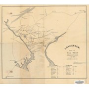
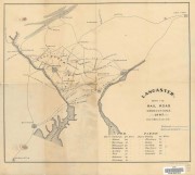
A reference map of Lancaster County, Pennsylvania showing the location and distances of the city, townships, boroughs, post-office and villages, together with the main roads (turnpikes), railroads and railroad stations, also the population of each township and borough as per census of 1890
Iron, railroad, canal and coal map of Pennsylvania, &c. : showing the relative position of the various anthracite and bituminous coal fields, the railroads, canals and navigable waters by which they are connected forming their respective avenues to market, also the furnaces, rolling mills, bloomeries and forges of Pennsylvania and adjoining states
Shows coal and oil regions from Lake Ontario through much of West Virginia; most of New York State is shown, though without geological detail. Also shows locations of steel works, foundries, etc.