Skip header and navigation

Revise Search

20 records – page 1 of 1.

Iron, railroad, canal and coal map of Pennsylvania, &c. : showing the relative position of the various anthracite and bituminous coal fields, the railroads, canals and navigable waters by which they are connected forming their respective avenues to market, also the furnaces, rolling mills, bloomeries and forges of Pennsylvania and adjoining states

https://collections.lancasterhistory.org/en/permalink/lhdo20328
Author
Sheafer, P. W.
Date of Publication
1867.
Call Number
Under Review
Responsibility
by P.W. Sheafer.
Author
Sheafer, P. W.
Place of Publication
Pottsville, Pa. ; Philadelphia
Publisher
Jacob Haehnlen [lithographer],
Date of Publication
1867.
Physical Description
1 map : col. ; 76 x 107 cm. on sheet 82 x 114 cm.
Notes
Shows coal and oil regions from Lake Ontario through much of West Virginia; most of New York State is shown, though without geological detail. Also shows locations of steel works, foundries, etc.
Subjects
Iron industry and trade - Pennsylvania - Maps.
Railroads - Pennsylvania - Maps.
Canals - Pennsylvania - Maps.
Coal - Pennsylvania - Maps.
Pennsylvania - Maps.
Location
Lancaster History Library - To be Reviewed
Call Number
Under Review
Less detail

Purpart E in the partition of the Cornwall estate allotted to Anne C. Alden, Marg C. Freeman and Sarah H. Coleman Dec. 31st 1881

https://collections.lancasterhistory.org/en/permalink/lhdo8433
Date of Publication
1881 ?]
Call Number
974.815 LACO 131
Place of Publication
[s.l
Publisher
s.n. ,
Date of Publication
1881 ?]
Physical Description
1 plan : ms., col. ; 29 x 49 cm.
Notes
"Kendal Bros. Reading, Pa. "
Situation date : 1881.
Includes index.
Subjects
Cornwall Estate - Pennsylvania - Lancaster County
Cornwall Estate (Lancaster County, Pa. )
Location
Lancaster History Library - Map
Call Number
974.815 LACO 131
Less detail

Map of the public roads in Lebanon County, Pennsylvania : constructed from actual surveys made under direction of the Department of Highways, by authority of an Act of Assembly approved May 31, 1911

https://collections.lancasterhistory.org/en/permalink/lhdo20365
Corporate Author
Pennsylvania. Dept. of Highways.
Edition
Rev. Feb. 1931.
Date of Publication
1931.
Call Number
Under Review
Corporate Author
Pennsylvania. Dept. of Highways.
Edition
Rev. Feb. 1931.
Place of Publication
[Harrisburg]
Publisher
Pennsylvania Department of Highways,
Date of Publication
1931.
Physical Description
1 map : col. ; 68 x 73 cm.
Notes
Map includes route numbers, railroads, streams, and important building locations.
Oriented with north toward top.
"March 1, 1914."
Subjects
Transportation - Pennsylvania - Lebanon County - Maps.
Railroads - Pennsylvania - Lebanon County - Maps.
Roads - Pennsylvania - Lebanon County - Maps.
Lebanon County (Pa.) - Maps.
Location
Lancaster History Library - To be Reviewed
Call Number
Under Review
Less detail

Lancaster with its rail road [sic] connections 1887

https://collections.lancasterhistory.org/en/permalink/lhdo15378
Corporate Author
J. L. Smith Map Publisher.
Date of Publication
[188-?]
Call Number
974.815 LACO 151
  1 document  
Alternate Title
Lancaster with its railroad connections 1887
Responsibility
J. L. Smith Map Publisher.
Corporate Author
J. L. Smith Map Publisher.
Place of Publication
Philadelphia, Pa
Publisher
J.L. Smith Map Publisher,
Date of Publication
[188-?]
Physical Description
1 map ; 35 x 42 cm.
Notes
Date of situation: 1887.
Includes table of distances.
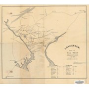
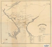
Shows lines for P.W. and B.R.R., B. and O. R.R., Balt. Cent. R.R., P.B.N.G.R.R., C. and P.D.R.R., P.B.R.R., Reading and CHesapeake R.R., CHes. Val. R.R., Lanc. and Del. R.R., Colebrok Valley R.R., and P. and R.R.R.
Subjects
Railroads - Pennsylvania - Lancaster County - Maps.
Mines and mineral resources - Pennsylvania - Lancaster County - Maps.
Location
Lancaster History Library - Map
Call Number
974.815 LACO 151
Documents

map_974.815_LACO_151_.pdf

Read PDF Download PDF
Less detail

Lebanon County Heritage Trail

https://collections.lancasterhistory.org/en/permalink/lhdo19361
Corporate Author
Lebanon City/County GIS Department.
Date of Publication
December 2007.
Call Number
974.819 502
Responsibility
map prepared by the Lebanon City/County GIS Department.
Corporate Author
Lebanon City/County GIS Department.
Place of Publication
Lebanon, Pa
Publisher
Lebanon County Historical Society,
Date of Publication
December 2007.
Physical Description
1 map : col ; 19 x 79 cm., on sheet 71 x 81 cm.
Notes
Acompanies book "Driving Tour of Lebanon County, Pennsylvania" BK 974.819 D782.
Also show Heritage Driving trail and walking trails.
Inset: City of Lebanon.
Subjects
Historic sites - Pennsylvania - Lebanon - Maps.
Historic sites - Pennsylvania - Lebanon County - Maps.
Lebanon County (Pa.) - Tours - Maps.
Lebanon (Pa.) - Tours - Maps.
Location
Lancaster History Library - Map
Call Number
974.819 502
Less detail

Metro street atlas of Lebanon county in Pennsylvania

https://collections.lancasterhistory.org/en/permalink/lhdo12678
Corporate Author
Franklin Maps (Firm)
Date of Publication
c1999.
Call Number
912.74819 F833
ISBN
1877911674
Corporate Author
Franklin Maps (Firm)
Place of Publication
King of Prussia, PA
Publisher
Franklin Maps,
Date of Publication
c1999.
Physical Description
1 atlas (47 p.) : col. maps ; 32 cm.
Series
Metro street atlas series
Notes
Cover title.
Includes indexes.
Subjects
Zip codes - Pennsylvania - Lebanon County - Maps.
Lebanon County (Pa.) - Maps.
Location
Lancaster History Library - Atlas
Call Number
912.74819 F833
Less detail

Discover cultural treasures, Lancaster County

https://collections.lancasterhistory.org/en/permalink/lhdo19262
Corporate Author
R.R. Donnelley and Sons Company. Mapping Services Division.
Date of Publication
[1991?]
Call Number
974.815 LACO 143
Responsibility
maps by Donnelley Mapping Services.
Corporate Author
R.R. Donnelley and Sons Company. Mapping Services Division.
Place of Publication
Lancaster, PA
Publisher
Cultural Council of Lancaster County,
Date of Publication
[1991?]
Physical Description
2 maps on 1 sheet : both sides, col. ; 34 x 37 cm. and 33 x 37 cm., sheet 47 x 38 cm., folded in cover 24 x 11 cm. + index/directory ([30] p. ; 24 cm.)
Notes
Shows arts organizations, libraries, museums, educational institutions, service organizations, and galleries.
Cover title.
Title at top: Discover cultural treasures.
Copyright "Bizcorp and Cultural Council of Lancaster County."
Includes notes, location map, and sponsors' advertisements.
Contents
Map A. Lancaster County -- Map B. Lancaster : city of Lancaster and vicinity.
Subjects
Arts facilities - Pennsylvania - Lancaster County - Maps.
Arts facilities - Pennsylvania - Lancaster - Maps.
Learned institutions and societies - Pennsylvania - Lancaster County - Maps.
Learned institutions and societies - Pennsylvania - Lancaster - Maps.
Museums - Pennsylvania - Lancaster County - Maps.
Museums - Pennsylvania - Lancaster - Maps.
Lancaster County (Pa.) - Maps, Tourist.
Lancaster (Pa.) - Maps, Tourist.
Additional Corporate Author
Cultural Council of Lancaster County (Pa.)
Bizcorp (Firm)
Location
Lancaster History Library - Map
Call Number
974.815 LACO 143
Less detail

Cemetery map of Lebanon County

https://collections.lancasterhistory.org/en/permalink/lhdo16172
Date of Publication
1996, 1969.
Call Number
974.819 503
Alternate Title
List of cemeteries of Lebanon County
Place of Publication
[Lebanon, Pa
Publisher
Lebanon County Historical Society],
Date of Publication
1996, 1969.
Physical Description
1 map : col. ; 96 x 64 cm.
Notes
Panel title.
Includes alphabetical list of 175 cemeteries.
"Revised 1996 by Christine Mason. The basis for this map was taken from the 1938 map donated to the Lebanon County Historical Society by Herman W. Louser."
Base map reprinted courtesy of the Commonwealth of Pennsylvania, Dept. of Transportation.
Original map base 1969 by Commonwealth of Pennsylvania, Dept. of Transportation.
Reprinted 1996 by Donald Blyler Offset.
Revised 1996 by Christine Mason.
Subjects
Cemeteries - Pennsylvania - Lebanon County - Maps.
Lebanon (Pa.) - History - Maps.
Additional Author
Mason, Christine.
Additional Corporate Author
Lebanon County Historical Society (Lebanon County, Pa.)
Donald Blyler Offset.
Location
Lancaster History Library - Map
Call Number
974.819 503
Less detail

Bicycle map, Lancaster County : a guide to bicycling, walking & transit

https://collections.lancasterhistory.org/en/permalink/lhdo19792
Corporate Author
Steve Spindler Cartography (Firm)
Date of Publication
[2004]
Call Number
974.815 LACO 513
Alternate Title
Lancaster County bicycle map
Responsibility
map produced for Lancaster County, Pennsylvania ; cartography--Steve Spindler Cartography ; design--Peter Volz Design ; project management--Toole Design Group.
Corporate Author
Steve Spindler Cartography (Firm)
Place of Publication
[Lancaster, Pa.]
Publisher
Lancaster County Planning Commission,
Date of Publication
[2004]
Physical Description
1 map : col. ; 64 x 67 cm., folded to 22 x 10 cm.
Notes
Bicycling conditions shown on road-map base.
Relief shown by shading.
"December 2004."
"Information on this map is accurate as of June 2004."
Title from panel.
Includes text, distance/travel-time table, and col. ill.
Text, directory of bicycle shops, and col. ill. on verso.
Maps on verso: City of Lancaster -- Transit map, Lancaster city routes -- County routes.
Subjects
Bicycle trails - Pennsylvania - Lancaster County - Maps.
Bicycle trails - Pennsylvania - Lancaster - Maps.
Bicycle stores - Pennsylvania - Lancaster County - Maps.
Bus lines - Pennsylvania - Lancaster County - Maps.
Bus lines - Pennsylvania - Lancaster - Maps.
Roads - Pennsylvania - Lancaster County - Maps.
Hiking - Pennsylvania - Lancaster County - Maps.
Additional Corporate Author
Peter Volz Design (Firm)
Toole Design Group.
Lancaster County Planning Commission.
Location
Lancaster History Library - Map
Call Number
974.815 LACO 513
Less detail

Map showing location and date of the earliest highways leading from the Delaware and Schulkill Rivers to the Susquehanna River and it's branches / by H. Frank Eshleman

https://collections.lancasterhistory.org/en/permalink/lhdo15534
Author
Eshleman, H. Frank
Date of Publication
1907.
Call Number
974.815 SEPA 100
  1 document  
Author
Eshleman, H. Frank
Place of Publication
Lancaster, Pa
Publisher
H. Frank Eshleman,
Date of Publication
1907.
Physical Description
1 map ; 22 x 41 cm.
Notes
Scale on map [ca. 1:418,176]. 3/4 in. = 5 mi.
May be a reduced reproduction of the original map.
Subjects
Roads - Pennsylvania - Lancaster County - Maps.
Roads - Pennsylvania - Chester County - Maps.
Roads - Pennsylvania - Delaware County - Maps.
Lancaster County (Pa.) - Maps.
Chester County (Pa.) - Maps.
Delaware County (Pa.) - Maps.
Location
Lancaster History Library - Map
Call Number
974.815 SEPA 100
Documents

map_974.815_SEPA_100_.pdf

Read PDF Download PDF
Less detail

The Underground Railroad, explorer's map & guide, Lancaster County, Pennsylvania

https://collections.lancasterhistory.org/en/permalink/lhdo15693
Corporate Author
Lancaster County Heritage (Project)
Edition
2nd ed.
Date of Publication
2001.
Call Number
974.815 LACO 107
Alternate Title
Underground Railroad, explorer's map & guide
Underground Railroad explorer's map and guide
Responsibility
Lancaster County Heritage ; brochure design--Lynn M. Stiles, Lancaster County Planning Commission.
Corporate Author
Lancaster County Heritage (Project)
Edition
2nd ed.
Place of Publication
Lancaster, Pa
Publisher
Lancaster County Heritage,
Date of Publication
2001.
Physical Description
1 map ; 19 x 21 cm., on sheet 59 x 42 cm., folded to 10 x 21 cm.
Notes
Shows Underground Railroad routes in Lancaster County (Pa.).
"September 2001."
Includes text, descriptive index of Underground Railroad historic sites, and location map.
Insets: 1. Columbia -- 2. Lancaster City -- 3. Christiana area.
Text, chronology, and ill. on verso.
Subjects
Underground railroad - Pennsylvania - Lancaster County - Maps.
Historic sites - Pennsylvania - Columbia - Maps.
Historic sites - Pennsylvania - Lancaster - Maps.
Historic sites - Pennsylvania - Christiana Region - Maps.
Heritage tourism - Pennsylvania - Lancaster County - Maps.
Additional Author
Stiles, Lynn M.
Additional Corporate Author
Lancaster County Planning Commission.
Location
Lancaster History Library - Map
Call Number
974.815 LACO 107
Less detail

The Comprehensive Plan for Lancaster County, Pennsylvania

https://collections.lancasterhistory.org/en/permalink/lhdo14600
Corporate Author
Lancaster County Planning Commission.
Date of Publication
2006.
Call Number
352.96 L245cp
Corporate Author
Lancaster County Planning Commission.
Place of Publication
Lancaster, Pa
Publisher
Lancaster County Planning Commission,
Date of Publication
2006.
Physical Description
4 vol. : ill., maps ; 28 cm.
Notes
Vol 1. Balance: the growth management element, April 2006 - vol. 2. Choices: the housing element, April 2006 - vol. 3. Heritage: the cultural heritage element: a strategy for preserving our sense of place, April 2006 - vol 4. Tourism: the strategic tourism development element, June 2005.
Cover title.
Subjects
Regional planning - Pennsylvania - Lancaster County - Maps.
Regional planning - Pennsylvania - Lancaster County.
Housing - Pennsylvania - Lancaster County.
Historic preservation - Pennsylvania - Lancaster County.
Location
Lancaster History Library - Book
Call Number
352.96 L245cp
Copy Info
2006
2005
Less detail

A map of historical sites and memorabilia of the City of Lebanon

https://collections.lancasterhistory.org/en/permalink/lhdo19448
Author
Leiby, Earl P.
Date of Publication
c1991.
Call Number
974.819 501
Responsibility
made available as a public service by the Lebanon County Historical Society ; researched, compiled, cartographed and prepared by Earl P. Leiby & Charles C. Stine ; with editing by Henry C. Westenberger & John J. Foster ; annexation map by Allen A. Freed.
Author
Leiby, Earl P.
Place of Publication
[Lebanon, Pa.]
Publisher
Lebanon County Historical Society,
Date of Publication
c1991.
Physical Description
1 map : col. ; 60 x 63 cm. + index ([7] p. ; 28 cm.)
Notes
Panel title.
Accompanied by: Index of locations on the map of historical sites and memorabilia of the City of Lebanon.
Index on verso.
In lower left margin: 147076.
Subjects
Historic sites - Pennsylvania - Lebanon - Maps.
Lebanon (Pa.) - History - Maps.
Additional Author
Stine, Charles C.
Westenberger, Henry C.
Foster, John J.
Freed, Allen A.
Additional Corporate Author
Lebanon County Historical Society (Lebanon County, Pa.)
Location
Lancaster History Library - Map
Call Number
974.819 501
Less detail

Lancaster County bicycle map

https://collections.lancasterhistory.org/en/permalink/lhdo15535
Date of Publication
2004.
Call Number
974.815 LACO 523
Responsibility
Steve Spindler Cartography ; Peter Volz Design ; Toole Design Group.
Place of Publication
[S.l.]
Publisher
Toole Design Group,
Date of Publication
2004.
Physical Description
3 maps on 1 sheet : both sides, col. ill. ; 63 x 67 cm. or smaller, on sheet 63 x 76 cm., folded to 22 x 20 cm.
Notes
"December 2004"--Verso.
"Map produced for Lancaster County, Pennsylvania."
Relief shown in shading.
Includes text, illustrations, table of travel time/distance.
Contents
On verso: City of Lancaster -- Transit map: Lancaster city routes - county routes.
Text. Recto: Bicycle tours of Lancaster County. Verso: Loading your bike onto the bus -- Bike shops and clubs -- Bicycle safety tips.
Subjects
Bicycle trails - Pennsylvania - Lancaster County - Maps.
Cycling - Pennsylvania - Lancaster County - Maps.
Roads - Pennsylvania - Lancaster County - Maps.
Lancaster County (Pa.) - Maps.
Lancaster County (Pa.) - Distances - Maps.
Additional Corporate Author
Steve Spindler Cartography (Firm)
Peter Volz Design (Firm)
Toole Design Group.
Lancaster County Planning Commission.
Location
Lancaster History Library - Map
Call Number
974.815 LACO 523
Less detail
Date of Publication
[1960?].
Call Number
974.815 RAPH 501
Responsibility
compiled by Lancaster County Assessment Department.
Place of Publication
Lancaster, Pa
Publisher
Lancaster County Assessment Department
Date of Publication
[1960?].
Physical Description
1 map ; 71 x 102 cm.
Notes
Appears in: Real Estate Atlas of Lancaster County, Pennsylvania. (LC 333.33 R288 1981.
Blue line print.
Contents
Map 9F.
Subjects
Tax assessment - Pennsylvania - Lancaster County
Real property - Pennsylvania - Lancaster County
Landowners - Pennsylvania - Lancaster County
Lancaster County (Pa.) - Maps.
Mount Joy (Pa. : Township) - Maps.
Rapho (Lancaster County, Pa. : Township) - Maps.
Location
Lancaster History Library - Map
Call Number
974.815 RAPH 501
Less detail

Lancaster County bus map

https://collections.lancasterhistory.org/en/permalink/lhdo15531
Corporate Author
Red Rose Transit Authority.
Date of Publication
[1987?]
Call Number
974.815 LACI 152
Alternate Title
Lancaster city bus routes
Lancaster County bus routes
Responsibility
Red Rose Transit Authority.
Corporate Author
Red Rose Transit Authority.
Place of Publication
Lancaster, Pa
Publisher
Red Rose Transit Authority,
Date of Publication
[1987?]
Physical Description
10 maps on 1 sheet : both sides, col. ; 60 x 57 cm. or smaller, on sheet 61 x 82 cm., folded to 21 x 12 cm.
Notes
Ancillary maps (recto): Elizabethtown -- Mount Joy -- Columbia -- Willow Street -- Manheim -- Lititz -- Ephrata -- New Holland.
"This map printed 11/87"--Panel.
Text and col. ill. on verso.
Contents
Lancaster County bus routes -- Lancaster city bus routes.
Subjects
Bus lines - Pennsylvania - Lancaster - Maps.
Bus lines - Pennsylvania - Lancaster County - Maps.
Bus lines - Pennsylvania - Elizabethtown - Maps.
Bus lines - Pennsylvania - Mount Joy - Maps.
Bus lines - Pennsylvania - Columbia - Maps.
Bus lines - Pennsylvania - Willow Street - Maps.
Bus lines - Pennsylvania - Manheim - Maps.
Bus lines - Pennsylvania - Lititz - Maps.
Bus lines - Pennsylvania - Ephrata - Maps.
Bus lines - Pennsylvania - New Holland - Maps.
Lancaster (Pa.) - Maps.
Lancaster County - Maps.
Location
Lancaster History Library - Map
Call Number
974.815 LACI 152
Less detail

Map of the public roads in Lancaster County, Pennsylvania : constructed from actual surveys made under direction of the State Highway Department by authority of an Act of Assembly approved May 31, 1911

https://collections.lancasterhistory.org/en/permalink/lhdo15375
Corporate Author
Pennsylvania. Dept. of Highways.
Edition
Rev. Feb. 1931.
Date of Publication
1931.
Call Number
974.815 LACO 514 Oversize
Corporate Author
Pennsylvania. Dept. of Highways.
Edition
Rev. Feb. 1931.
Place of Publication
[Harrisburg, Pa.]
Publisher
Pennsylvania Dept. of Highways,
Date of Publication
1931.
Physical Description
1 map : col. ; 116 x 114 cm.
Notes
Map includes route numbers, railroads, streams, and important building locations.
"January 1912."
Subjects
Transportation - Pennsylvania - Lancaster County - Maps.
Railroads - Pennsylvania - Lancaster County - Maps.
Lancaster County (Pa.) - Maps.
Location
Lancaster History Library - Map
Call Number
974.815 LACO 514 Oversize
Less detail

Map of greater Lancaster : including maps of Lancaster City & County

https://collections.lancasterhistory.org/en/permalink/lhdo12833
Corporate Author
R.R. Donnelley and Sons Company. Cartographic Services.
Date of Publication
c1988.
Call Number
974.815 LACO 138
Responsibility
all maps prepared by R.R. Donnelley & Sons Co., Cartographic Services.
Corporate Author
R.R. Donnelley and Sons Company. Cartographic Services.
Place of Publication
Lancaster
Publisher
Lancaster Chamber of Commerce and Industry,
Date of Publication
c1988.
Physical Description
6 maps on 1 sheet : both sides, col. ; 56 x 49 cm. or smaller, sheet 56 x 88 cm.
Notes
Panel title.
"Copyright Bizcorp 1988."
Includes notes, indexes, directories, statistical table, location map inset, and col. ill.
Contents
Greater Lancaster -- Lancaster -- [Central business district] -- [Lancaster County showing points of interest, school districts, and historic districts] -- [Regional location map] -- Lancaster County municipal information.
Subjects
Central business districts - Pennsylvania - Lancaster - Maps.
Historic districts - Pennsylvania - Lancaster County - Maps.
School districts - Pennsylvania - Lancaster County - Maps.
Lancaster (Pa.) - Maps.
Lancaster Metropolitan Area (Pa.) - Maps.
Lancaster County (Pa.) - Maps.
Lancaster County (Pa.) - Maps, Tourist.
Additional Corporate Author
Lancaster Chamber of Commerce and Industry (Pa.)
Bizcorp (Firm)
Location
Lancaster History Library - Map
Call Number
974.815 LACO 138
Less detail

Early landowners of Pennsylvania

https://collections.lancasterhistory.org/en/permalink/lhdo18990
Author
MacInnes, Sharon Cook.
Edition
1st ed.
Date of Publication
c2008.
Call Number
912.74815 M152
Alternate Title
Atlas of township patent maps of Lancaster County, PA
Responsibility
Sharon Cook MacInnes, Angus MacInnes.
ISBN
9781558564978
1558564977
Author
MacInnes, Sharon Cook.
Edition
1st ed.
Place of Publication
Apollo, Pa
Publisher
Closson Press,
Date of Publication
c2008.
Physical Description
1 atlas (xi, 527 p.) : maps ; 28 cm.
Notes
Includes bibliographical references (p. xi) and index.
Subjects
Landowners - Pennsylvania - Lancaster County - Maps.
Landowners - Pennsylvania - Lancaster County - Registers.
Real property - Pennsylvania - Lancaster County - Maps.
Lancaster County (Pa.) - Genealogy.
Additional Author
MacInnes, Angus.
Location
Lancaster History Library - Reference
Call Number
912.74815 M152
Less detail

Map of Lancaster County, Pennsylvania

https://collections.lancasterhistory.org/en/permalink/lhdo19526
Author
Scott, Joshua.
Date of Publication
1824.
Call Number
912.74815 L244 1824
  1 website  
Responsibility
respectfully dedicated to the inhabitants by Joshua Scott.
Author
Scott, Joshua.
Place of Publication
Lancaster
Publisher
[s.n.],
Date of Publication
1824.
Physical Description
1 map : hand col., cloth backing ; 87 x 115 cm., folded to 93 x 61 cm.
Notes
General-content county map also showing election districts.
Hand col. to emphasize township boundaries and territories.
Relief shown by hachures.
Orientated with north toward the upper left.
Prime meridian: Washington (D.C.).
Published "Lancaster January 1st 1824".
Originally printed on 4 sheets (later conjoined).
Copy 2: From the collections of the Heritage Center, P05.29.1.
LC Land ownership maps,
Copy 2: green boards.
Copy 1: Marble boards, three-quarater red leather, spine taped.
Subjects
Election districts - Pennsylvania - Lancaster County - Maps.
Landowners - Pennsylvania - Lancaster County - Maps.
Election districts.
Landowners.
Lancaster County (Pa.) - Maps.
Pennsylvania - Lancaster County.
Maps.
Location
Lancaster History Library - Rare Books
Call Number
912.74815 L244 1824
Websites
Less detail

20 records – page 1 of 1.